Report on Montagu Island (United Kingdom) — January 2004
Bulletin of the Global Volcanism Network, vol. 29, no. 1 (January 2004)
Managing Editor: Richard Wunderman.
Montagu Island (United Kingdom) Eruption continues through 2003; new image shows ash and lava
Please cite this report as:
Global Volcanism Program, 2004. Report on Montagu Island (United Kingdom) (Wunderman, R., ed.). Bulletin of the Global Volcanism Network, 29:1. Smithsonian Institution. https://doi.org/10.5479/si.GVP.BGVN200401-390081
Montagu Island
United Kingdom
58.445°S, 26.374°W; summit elev. 1370 m
All times are local (unless otherwise noted)
The first recorded eruption of Montagu island (sometimes called Belinda volcano) has continued for more than two years according to satellite thermal imagery (see BGVN 28:02). First detected on imagery from the Moderate Resolution Imaging Spectroradiometer (MODIS) satellite on 20 October 2001 by the MODVOLC automated monitoring system at the University of Hawaii Manoa, the eruption appeared to continue with persistent low-level ash emission and occasional lava effusion into at least December 2003.
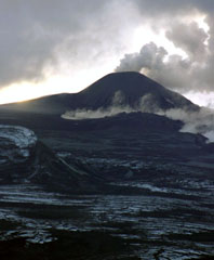
MODIS thermal anomalies have been present on a regular basis since the 20 October 2001 eruption. Figure 5 shows the MODIS-measured radiative heat output through 2003 (see also Wright and Flynn, 2004). High heat output occurred in August 2002, perhaps corresponding to lava effusion down the W flank of the cinder cone (figure 6). Following a relaxation in heat output levels, values rose again in late 2003, the highest level occurring in October 2003.
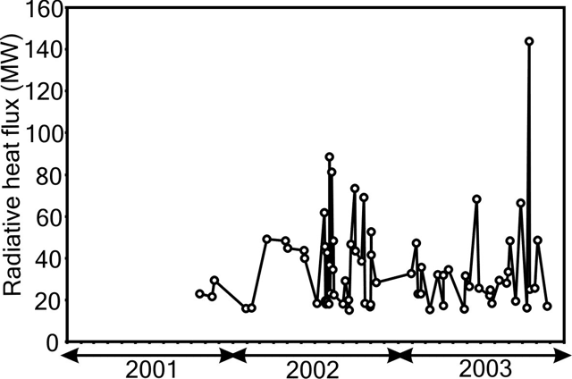 |
Figure 5. Radiative heat output from Montagu during the period October 2001-December 2003 measured by the MODVOLC monitoring system using MODIS satellite data. Courtesy of the HIGP Thermal Alerts Team, Hawai'i Institute of Geophysics and Planetology (HIGP). |
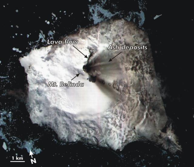 |
Figure 6. Montagu Island and the surrounding iceberg-laden seas appear in this ASTER satellite image (visual spectrum, bands 3-2-1, 15 m pixel size) take on 7 December 2003. This image shows recent volcanic deposits on Montagu's ice-covered surface. The image will also help refine existing maps. The volcano on the island's lower right-hand extreme is called Mount Oceanite. Courtesy of NASA/ GSFC/ MITI/ ERSDAC/ JAROS, and U.S./ Japan ASTER Science Team. |
High-resolution images from the Advanced Spaceborne Thermal Emission and Reflection Radiometer (ASTER) satellite (15 m pixel size) and the Landsat Enhanced Thematic Mapper Plus (ETM+) (15-30 m pixel size) were used to examine the processes acting on the surface. An ETM+ image on 4 January 2002 showed a ~600 m lava flow near the summit of the cinder cone while low-level ash emission ensued. An ASTER image on 1 August 2003 showed a 2-km-long lava flow that was emplaced on the summit ice cover, corresponding, perhaps, to a 25 July 2003 MODIS radiance spike. The flow emanated from the summit of the cinder cone in a NE trend and cut through the ice cover creating a deep gully that confined the flow laterally. The gully, ~ 100 m wide near the source, swelled to a fan-shaped chasm ~600 m in diameter. An ash-rich plume was observed and ubiquitous ash cover blanketed the E half of the island. An ASTER image on 7 December 2003 showed the cooling lava flow devoid of snow cover with a small ash plume drifting SE from the summit (figure 6).
The high-resolution ASTER images improved previously published maps, leading to revised estimates of the island's size. Thus, previously reports described the island as 15 x 20 km across, but a better estimate is 10 x 12 km. The previous sketch map (in BGVN 28:02) had the correct scale.
The ASTER images also provide some of the first clear views of the island's morphology and some of the recent deposits. The active cinder cone is a small peak situated on the N side of an extensive and gently sloping ice field. This ice field fills the largest caldera known in the island group, a feature ~6 km in diameter and filled by permanent ice of uncertain depth. Mount Oceanite forms a conspicuous promontory on the SE corner of the island with a 270-m-diameter summit crater (figure 6).
Satellite remote sensing of remote regions. The South Sandwich Islands are situated well to the E of the southern tip of South America and over 10 degrees N of mainland Antarctica. They comprise a volcanic province called the Scotia arc, formed by the subduction of the South American plate beneath the Scotia plate. Due to this region's inaccessibility, satellite monitoring holds promise as a means to track volcanism there.
Terra (Latin for land) is the name of the Earth Observing System (EOS) flagship satellite that began science operations in 2000. Terra is a multi-national, multi-disciplinary satellite carrying a payload of five remote sensors that are measuring comprehensively the state of Earth's environment and ongoing changes in its climate system. The Terra MODIS sensor detects thermal data and forms part of the satellite monitoring system called MODVOLC. The monitoring system is run by the HIGP Thermal Alerts Team at the University of Hawaii-Manoa.
Another sensor on Terra is ASTER (Advanced Spaceborne Thermal Emission and Reflection Radiometer), an imaging instrument. This sensor, a cooperative effort between NASA and Japan's Ministry of Economy, Trade, and Industry (METI), and the Earth Remote Sensing Data Analysis Center (ERSDAC), provides detailed maps of land surface temperature, emissivity, reflectance, and elevation.
References. Wright, R., and Flynn, L.P., 2004, A space-based estimate of the volcanic heat flux into the atmosphere during 2001 and 2002: Geology, v. 32, p. 189-192.
Wright, R., Flynn, L.P., Garbeil, H., Harris, A.J.L., and Pilger, E., (in press), MODVOLC: near-real-time thermal monitoring of global volcanism: Journal of Volcanology and Geothermal Research, Elsevier (2004)
Geological Summary. The largest of the South Sandwich Islands, Montagu consists of a massive shield volcano cut by a 6-km-wide ice-filled summit caldera. The summit of the 11 x 15 km island rises about 3,000 m from the sea floor between Bristol and Saunders Islands. Around 90% of the island is ice-covered; glaciers extending to the sea typically form vertical ice cliffs. The name Mount Belinda has been applied both to the high point at the southern end of the summit caldera and to the young central cone. Mount Oceanite, an isolated peak at the SE tip of the island, was the source of lava flows exposed at Mathias Point and Allen Point. There was no record of Holocene activity until MODIS satellite data, beginning in late 2001, revealed thermal anomalies consistent with lava lake activity. Apparent plumes and single anomalous pixels were observed intermittently on AVHRR images from March 1995 to February 1998, possibly indicating earlier volcanic activity.
Information Contacts: Matt Patrick, Luke Flynn, Harold Garbeil, Andy Harris, Eric Pilger, and Rob Wright, HIGP Thermal Alerts Team, Hawai'i Institute of Geophysics and Planetology (HIGP) / School of Ocean and Earth Science and Technology (SOEST), University of Hawai'i, 2525 Correa Road, Honolulu, HI 96822, USA (URL: http://modis.higp.hawaii.edu/); John Smellie, British Antarctic Survey, Natural Environment Research Council, High Cross, Madingly Road, Cambridge CB3 0ET, United Kingdom (URL: https://www.bas.ac.uk/).