Report on Ol Doinyo Lengai (Tanzania) — February 2004

Bulletin of the Global Volcanism Network, vol. 29, no. 2 (February 2004)
Managing Editor: Edward Venzke.
Ol Doinyo Lengai (Tanzania) During February 2004, lavas still escape crater; temperature measurements
Please cite this report as:
Global Volcanism Program, 2004. Report on Ol Doinyo Lengai (Tanzania) (Venzke, E., ed.). Bulletin of the Global Volcanism Network, 29:2. Smithsonian Institution. https://doi.org/10.5479/si.GVP.BGVN200402-222120
Ol Doinyo Lengai
Tanzania
2.764°S, 35.914°E; summit elev. 2962 m
All times are local (unless otherwise noted)
Activity at Ol Doinyo Lengai has continued intermittently since October 2002 (BGVN 27:10). (According to Fred Belton, in that same month, October 2002, Paramount Pictures used the crater to shoot footage for the film "Tomb Raiders II.").
This summary report for 2003 is based on observations made by Joerg Keller, Jurgis Klaudius, Fred Belton, and Christoph Weber, as well as information collected by Celia Nyamweru from visits to the area. Christoph Weber most recently visited Lengai in February 2004, when he collected GPS data for a new, precise crater map (figure 78). He also took temperature measurements of fumaroles and lava flows (see tables 5 and 6), and gathered lava samples to be given to research departments.
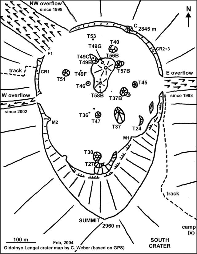 |
Figure 78. GPS-aided sketch map of the crater at Ol Doinyo Lengai made on 14 February 2004. Note the lava flow paths over the crater's margin on onto the flanks ("overflows") that have started in the past several years. Subsequent figures (photos) help clarify the shapes and sizes of hornitos and other features. Naming conventions are complicated by the crater's rapidly changing landscape, including such processes at hornitos as collapse, clustering, and overlap. For example, hornito T48, which was described as having collapsed in July 2000, lies on the N margin of the hornito labeled as T58B. The lava ponds seen by Hloben in January 2001 are not shown, although some of their locations may coincide with later features. For detailed comparison of crater evolution and naming conventions, consult previous maps (eg., BGVN 27:10). Courtesy of Christoph Weber, Volcano Expeditions International and Volcano Hazards Documentation and Logistic Research. |
Table 5. Lava temperature measured at Ol Doinyo Lengai by a digital thermometer (TM 914C with a stab feeler, standard K-Type). The instrument was used in the 0-1200° Celsius mode. Calibration was made using the delta-T method, where temperature values are ± 6°C in the 0-750°C range associated with at least four replicate measurements at one spot. Courtesy of Christoph Weber.
| Date | Location | Temperature (°C) |
| 28 Aug 1999 | T40 lava lake | 529 |
| 01 Sep 1999 | Pahoehoe flow in a tube near T40 | 519 |
| 01 Sep 1999 | Aa flow still in motion on flat terrain (60 cm thick) | 516 |
| 03 Oct 2000 | Pahoehoe flow in a tube near T49B | 507 |
| 03 Oct 2000 | Aa flow still in slow motion on flat terrain (25 cm thick) | 496 |
| 11 Feb 2004 | Pahoehoe flow in a tube near T49G | 588 |
| 12 Feb 2004 | Pahoehoe flow in a tube near T49B | 579 |
| 13 Feb 2004 | Aa flow immobile and on flat terrain (15 cm thick) | 490 |
Table 6. Fumarole temperatures measured at cracks in the crater floor of Ol Doinyo Lengai, using the above-described digital thermometer. Courtesy of Christoph Weber.
| Date | Location | Temperature (°C) |
| 28 Aug 1999 | F1 | 70 |
| 28 Aug 1999 | Near T49 | 82 |
| 03 Oct 2000 | Near T49C | 75 |
| 03 Oct 2000 | F1 | 69 |
| 20 Oct 2002 | The hottest cracks in the crater floor | 124 |
| 20 Oct 2002 | F1 | 78 |
| 30 Jun 2003 | F1 | 86 |
| 30 Jun 2003 | Near T49C | 76 |
| 12 Feb 2004 | F1 | 88 |
Summary of 2003 activity. During the first half of 2003, two new hornitos appeared in the center of the active crater at Ol Doinyo Lengai at the T49 and T58B (T48) locations (see figure 78 and caption). A huge lava pond appeared at these locations and caused several lava flows in all directions. According to Burra Gadiye, a local Lengai observer, by mid-June unusually dramatic activity started at both new hornitos. An expedition led by Frederick Belton in August 2003 reported that strong degassing and rhythmic explosive eruptions threw lapilli, ash, and lava spatter to 100 m above the hornito. Those eruptions, best described as Strombolian, continued until January 2004. They were accompanied by several lava flows and built up the comparatively tall strato-type hornitos at the T49-T56B locations and at the T48-T48B-T58B locations. The summit of T48B stood just above the former T44 hornito, but T44 itself was no longer visible.
Observations during February 2004. An expedition team including Christoph Weber and others visited Lengai for five days, 10-14 February 2004 (figures 79, 80, and 81). The team used GPS to conclude that the summit of the tallest hornito, located in the center area of the active crater at Ol Doinyo Lengai (T49 or T56B location), was at approximately 2,886 m elevation, standing about 33 m above the surrounding crater floor to the N. While this hornito was no longer active, T48B (T58B) contained a lava lake deep inside, which was clearly indicated by noise and tremor. Observers in February noted effusive and lava lake activity. This occurred at the old T49 eruption center, also indicated by the activity of T49B during observation and an active new vent (numbered T49G by Weber, figure 81) at the N flank of T49 (T56B), about half way up from its base to the N side.
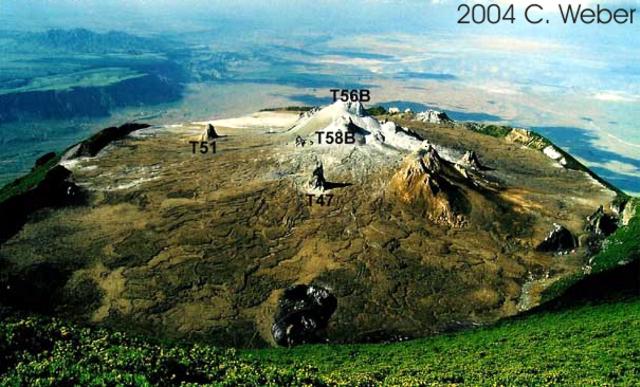 |
Figure 79. Ol Doinyo Lengai as seen in February 2004 from its summit, looking towards the actively erupting N crater. Courtesy Christoph Weber. |
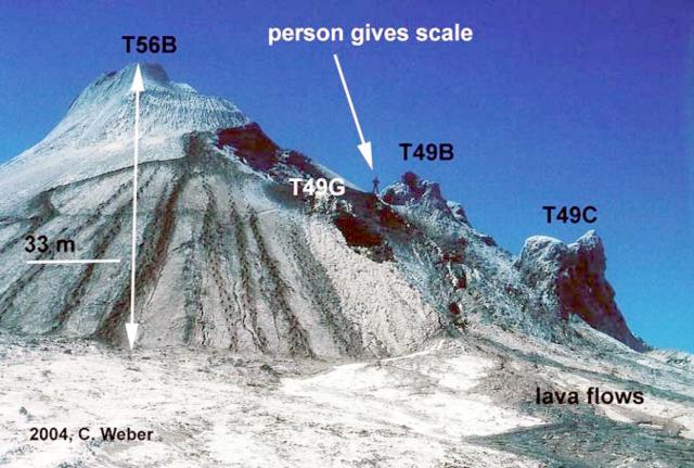 |
Figure 80. View of the tallest hornito (T56B) at Ol Doinyo Lengai in February 2004. T56B sits in the center of the active (N) crater. The hornito's summit was at 2,886 m elevation. Lava flows are visible in the foreground. Courtesy Christoph Weber. |
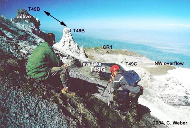 |
Figure 81. View of Ol Doinyo Lengai looking towards the W, facing the lava lake at T49G and the active peak at T49B. Courtesy Christoph Weber. |
This new activity probably caused two collapses (which left depressions) in the N flank of T49 (T56B), seen since January 2004. The T49G vent, located at the upper collapse, had a steady degassing lava lake with many overflows recorded during the February visit. Lava penetrated the lower collapse at T49 and lava flows reached as far as the NW overflow. On 12 and 13 February the T49B vent spattered lava for hours, feeding lava flows to the W (to the vicinity of T51), and finally escaping into a lava tube system. The lava temperature very close to the lava lake was measured at 588°C. Immobile aa lava flows on flat terrain were measured between 480°C and 500°C (table 5).
On 7 February team members Christoph Weber and R. Albiez were staying at the N slope of the neighboring Karimassi volcano and heard a paroxysm at T48B (T58B) lasting 30 seconds. During the visit on 10 February evidence of this paroxysm included fresh lava spatter and bombs cast around T58B for a radius of ~ 100 m.
Evacuation project at Ol Doinyo Lengai. Contributors to this report belong to a group committed to creating and funding evacuation plans. That group is called Volcano Hazards Documentation and Logistic Research (see Information Contacts). The group is working with the local Masaii and authorities on preparations in case of a dangerous eruption.
Geological Summary. The symmetrical Ol Doinyo Lengai is the only volcano known to have erupted carbonatite tephras and lavas in historical time. The prominent stratovolcano, known to the Maasai as "The Mountain of God," rises abruptly above the broad plain south of Lake Natron in the Gregory Rift Valley. The cone-building stage ended about 15,000 years ago and was followed by periodic ejection of natrocarbonatitic and nephelinite tephra during the Holocene. Historical eruptions have consisted of smaller tephra ejections and emission of numerous natrocarbonatitic lava flows on the floor of the summit crater and occasionally down the upper flanks. The depth and morphology of the northern crater have changed dramatically during the course of historical eruptions, ranging from steep crater walls about 200 m deep in the mid-20th century to shallow platforms mostly filling the crater. Long-term lava effusion in the summit crater beginning in 1983 had by the turn of the century mostly filled the northern crater; by late 1998 lava had begun overflowing the crater rim.
Information Contacts: Christoph Weber, Volcano Expeditions International, Muehlweg 11, 74199 Untergruppenbach, Germany (URL: http://www.v-e-i.de); Celia Nyamweru, Department of Anthropology, St. Lawrence University, Canton NY 13617 USA (URL: http://blogs.stlawu.edu/lengai/); Jurgis Klaudius, IMPG, Albert-Ludwig-University Freiburg, Albertstrasse 23b, 79104 Freiburg, Germany; Frederick Belton, 3555 Philsdale Ave., Memphis, TN 38111 USA (URL: http://oldoinyolengai.pbworks.com/); Volcano Hazards Documentation and Logistic Research, VHDL; Germany, Muehlweg 11, 74199 Untergruppenbach (URL: http://www.v-e-i.de/vhdl/).