Report on Llaima (Chile) — February 2004
Bulletin of the Global Volcanism Network, vol. 29, no. 2 (February 2004)
Managing Editor: Edward Venzke.
Llaima (Chile) Extreme glacial crevassing and melting; April 2003 ash emissions
Please cite this report as:
Global Volcanism Program, 2004. Report on Llaima (Chile) (Venzke, E., ed.). Bulletin of the Global Volcanism Network, 29:2. Smithsonian Institution. https://doi.org/10.5479/si.GVP.BGVN200402-357110
Llaima
Chile
38.692°S, 71.729°W; summit elev. 3125 m
All times are local (unless otherwise noted)
During late 2002 and early 2003 Chilean scientists at Llaima documented increases in seismicity, fumarolic output, a minor eruption, and pronounced glacial disruption. For example, on 8 January 2003 they found that the ice and snow formerly capping the N and S craters had completely melted. Larger eruptions began in April 2003, depositing pyroclastic material, dispersing numerous ballistic blocks, and creating substantial plumes.
Although this report covers the time interval from January 2002 through most of April 2003, the concern then was that Llaima might erupt with the vigor seen in 1994 (BGVN 19:04 and 19:05). However, during the 2002-03 reporting interval eruptions remained comparatively modest.
Ice covered, passively degassing. On 26 September and 30 October 2002, scientists from Chile's Volcanic Risk Program and the Volcanologic Observatory of the South Andes (OVDAS) flew over Llaima in response to steady increases in seismicity and fumarolic activity since the end of June 2002. On the 26 September flight they viewed the summit with its N (main) crater, and Pichillaima, the smaller SE-flank cone and its crater. They found only a weak steam plume rising gently from the main crater and attaining little additional height. This was in contrast to typical previous behavior, which consisted of puffs that rose several hundred meters before dissipating.
The 26 September 2002 aerial observations found the internal walls of the main crater draped in ice and snow. Pichillaima lay beneath a cover of clean ice and snow, and its crater emitted only a small gas plume. The overall scene was of quiet, with minor degassing amid frigid conditions.
Views of the main crater rim on 30 October 2002 indicated minor ash on the snow, an irregular, figure-eight-shaped hole emitting gases, and a much larger and optically denser steam plume than on 26 September. Llaima's cover of ice and snow was more complete than noted in October 1998. Thus, by comparison, in late 2002 visible signs of thermal activity had diminished significantly. In contrast to what was typically seen, the crater's ice-covered internal walls lacked escaping gases. Except for seismicity, the ice-bound Llaima seemed stable.
Seismically restless. Despite the lack of visible volcanism or thermal activity, the seismicity in September 2002 was notably greater than in January 2002 (table 2). The frequency of tremor increased from 0.9 Hz in January 2002 (a typical value in times of relative quiet) to 1.2 Hz in September 2002. In describing April 2003 tremor amplitude the OVDAS reports stated that it was about "5-fold larger" than at base level.
Table 2. Seismic activity at Llaima summarized as RSAM (Real-time seismic amplitude) values and principal tremor frequencies. In times of relative quiet, baseline values at Llaima are ~ 20 RSAM units and 0.9 Hz. These data were taken from reports by OVDAS-SERNAGEOMIN (which omitted some time intervals).
| Date | Seismicity (RSAM units) | Tremor frequency (Hz) |
| Jan 2002 | 28 | 0.9 |
| Jun 2002 | 20 | -- |
| Sep 2002 | 57 | 1.2 |
| Dec 2002 | 99 | 1.2 (during 18-20 Dec) |
| Mid-Jan 2003 | 93 | -- |
| Late Jan 2003 | 60 | -- |
| Apr 2003 | 92 | 1-2.2 |
| 18-19 Apr 2003 | 98 | -- |
In September 2002, seismic instruments included two permanent stations (LLAI and MELI) located respectively on Llaima's S flank and S foot. In December 2002, there were two portable seismic receivers placed on the E flank at Lago Verde, which also recorded unrest. The seismicity continued to increase from December 2002 to mid-January 2003 (from ~70 to ~100 RSAM units). After that, it diminished and stabilized for about two months.
Sudden changes. A flight on 8 January 2003 led OVDAS to see remarkable changes since the late 2003 observations (figure 11). First, the dense fumarole emitted from the main crater was much stronger than the one seen 26 September 2002 (figure 11, top left). Second, the ice and snow had completely melted from main crater's internal walls. Third, complete melting of ice and snow had left exposed rock at both the summit and Pichillaima (figure 11, lower right). Fourth, numerous new crevasses had appeared in the cone's glaciers, particularly on the E flank. Down all flanks of the volcano, the 8 January observers saw ice falls, snow avalanches, ice detachments, and rockfalls.
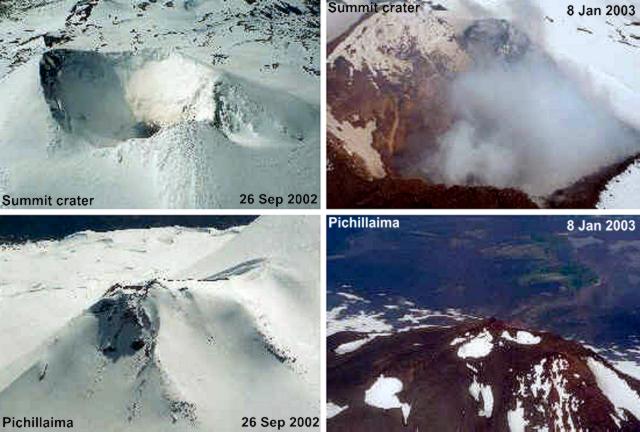 |
Figure 11. Contrasting views of Llaima's summit crater and Pichillaima as seen on 26 September 2002 (left, top and bottom, respectively) compared to 8 January 2003 (right, top and bottom, respectively). The scenes highlight differing conditions, particularly the melting of ice and snow. On 26 September 2002 snow covered most of the edifice. On 8 January 2003 there was an absence of significant ice and snow from parts of the crater walls, rim, and S flanks, and there were increased emissions of volcanic gases. Courtesy of OVDAS-SERNAGEOMIN. |
Although the melting came at the time of the annual thaw, the situation on the volcano indicated that processes such as local heating accelerated the melting. Snow had fallen in early October 2002. The absence of ice and snow cover on both the shaded and unshaded sides of Llaima was cited as evidence indicating elevated rock temperature. Observers saw the melting and also noted a halt to any new accumulation of ice and snow deposits. The melting was attributed to magma at depth in the conduit, and considerable heat emerging at the locations where the ice melted.
The report issued 20 January 2003 noted that field work on Llaima's W side (Cherquenco-El Salto) had disclosed deep new crevasses in the glacial ice reaching 1.5 km long. These were affiliated with avalanching from near the main cone's summit to the cone's NW foot (~ 3 km long by 0.5 km wide). Observers also noticed continued signs of thawing, including the appearance of small fumaroles, which they again attributed to the volcano warming.
The next available reports, from the period 9-11 April, came from eye-witnesses. Rodrigo Marín of Conguillío national park, noted "an increase of fumarole activity in the main crater between 9 and 10 April, which was accompanied by ash emission." In addition, from the N slope (Captrén) people heard underground noises.
At 1330 on 10 April a teacher at Los Andes de Melipeuco elementary school noted three ash explosions that reached ~ 500 m above the main crater and dispersed NE. Several others observers noted ash-bearing emissions from the main crater, including one at 1340 and another at 1350. A park ranger noted that around 2100-2200 on 10 April strong and continuous explosions awoke him and ash began to fall on him in the N-slope sector of Captrén. Later, the explosions became more sporadic, and he heard sounds similar to those made by the motion of heavy machinery. This continued into the early morning of 11 April.
The director of the above-mentioned school reported to OVDAS that on 11 April at 0915 he saw "...continuing ash emission from the main crater." Finally, at 1100 on 11 April, OVDAS observatory (Cerro ñielol-Temuco) staff observed a vertical column, mainly of volcanic gases, which rose to about 600-700 m above the crater rim. This fed a large, horizontal, lenticular cloud ~ 30 km in diameter, the top of which rose to about 3,900 m altitude.
An 11 April helicopter flight disclosed a thin layer of pyroclastic material spread widely across the glaciers on the NE, E, SE, and SW flanks, visible out to distances of ~ 4 km. Impact craters in the ice testified to numerous bouncing and rolling projectiles. Scientists on that flight noted vigorous fumarolic activity and dense clouds with colors and odors indicating the presence of SO2 and HCl. At multiple spots, small fumaroles had sprouted from the crater walls. The crater floor contained a 50-m-diameter vent emitting gases, but no lava flows had emerged. Although the 9-11-April eruptions were modest, they prompted Llaima's hazard status to rise from Green to Yellow.
Figure 12 portrays further melting and exposure of underlying rock at both the summit (top) and Pichillaima (bottom) on 11 April. When photographed, the ice and snow at Pichillaima had receded by 1.0-1.5 km from its topographic high. Ice margins appeared sub-vertical and engulfed circular melt areas.
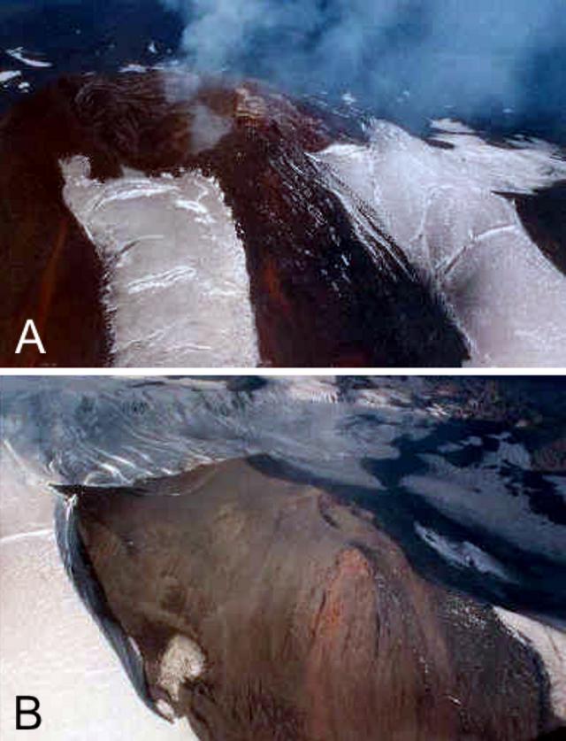 |
Figure 12. Two vistas of Llaima on 11 April 2003 documenting the rapid ice recession and melting around the main crater and Pichillaima. (A) Rim and flanks of the summit and associated main crater standing with large areas ice free. (B) Pichillaima, nearly ice free and encircled by thick ice at the limit of ice melting. Courtesy of OVDAS-SERNAGEOMIN. |
Other amazing photos taken 11 April 2003 revealed dramatic changes in glaciers and snow fields (figure 13). Many regions of the ice appeared to be in motion and undergoing acute mechanical failure. Numerous profound crevasses had emerged, including sets of broadly transverse, arcuate crevasses trending from glacial margins and extending well into their axial areas.
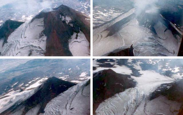 |
Figure 13. Four views of Llaima from helicopter, taken on 11 April 2003 showing newly exposed rock surfaces, newly created ice-margins, and unstable, rapidly breaking glaciers. Llaima's comparatively temperate late-2002 to early-2003 eruptive phase correlated with these remarkable changes in its alpine glaciers. Courtesy of OVDAS-SERNAGEOMIN. |
On 12-13 April 2003 the main crater issued intense pulsing fumarolic degassing at 1- to 3-minute intervals. Odors and celeste color were again indicative of SO2 and HCl components; such emissions were noted until 1500 on 13 April. Other processes on those days included mass wasting, sometimes with associated dust, apparent vibrations at the summit, and ballistic discharges from the main crater. At 1310 on 13 April, expulsions intensified and occurred at 1 minute intervals. Plumes blew E.
Continued observations resulted in the recommendation to maintain the Yellow status at least through 16 April as eruptions began to contain significant tephra. Volcanologists expressed concern that the volcano's glacial ice-cover could undergo further melting, which might lead to large and sudden outbursts of water (glacier bursts) traveling down local drainages.
On 16 April at 1453 OVDAS personnel in the Lago Verde area confirmed gaseous emissions were continuing to escape from the crater. They reported that at 1535 these emissions intensified and reached 200 m above the crater rim, with the plume blowing SE and being visible for ~ 8 km. They noted that at 1537 gaseous emissions escaped at Pichillaima. On the N (Captrén) side of the mountain at 1704 the observers saw gray-colored fumaroles. During 1130-1355 on 17 April from a point near the Lago Verde they perceived SO2 and HCl; they witnessed gas emissions to the NE reaching 200 m above the crater rim and spawning a plume visible for ~ 10 km.
The 20 and 23 April 2003 OVDAS reports discussed poor visibility but the permanent stations indicated high-amplitude tremor and considerable seismicity (eg., 98 RSAM units on 18 and 19 April). OVDAS staff interpreted these signals as due to fluids and gases moving in internal conduits. They also pointed out the absence of high- and low-frequency earthquake swarms, signals that generally precede emissions of ash. Small swarms of long-period earthquakes began, however, on 25 April.
Ascent during mid-April 2003. In mid-April 2003 Klaus Bataille (a physicist and seismologist teaching geophysics at the University of Concepción) and his students conducted field work on Llaima. Amid an interval of seismic and volcanic quiet on 18 April they ascended into the region of ice melt near the summit region, and made direct observations relevant to the issue of heat transport. Bataille made the following comments.
"A week after the explosion announced by the OVDAS, we (8 students and myself) went to install two broadband seismic stations to study the evolution of its activity, and we installed a GPS receiver as well. When we finished with the installation, it was a clear day and we decided to climb as much as we could. We began early in the morning [of 18 April] . . . [and] could see from the distance fumaroles coming from the crater, and several vents with vapor and gases coming out from different places, some 200-300 m below the crater, towards the N. We did not find any impediment to continue climbing, neither physical difficulties nor anomalous activity from the crater. Thus the whole group continued up to 300 m below the crater, where four persons stayed due to physical conditions, and five continued up to the crater. The persons who stayed (me included) realized that there was an incredible warm feeling while laying on the ground. This was due to the amount of vapor with some faint smell of sulphur. We could even take off our jackets and shirts, as long as we were laying flat. After lying for a while it was even too hot to [continue]. Fantastic feeling, lying almost on top of the volcano, with a tremendous view, feeling the warmth through the rocks."
Thus, on 18 April, Bataille and students affirmed the previously stated idea of heat emerging to cause the melting and leading to the sudden emergence of crevasses observed since December 2002. A later clarification from Bataille on the mode of heat transfer (viz., "conductive heating," passed through the rocks; or "convective heating," transported by warmed fluids such as gases) resulted in this statement: "I'm not convinced of 'conductive heating' as a direct source for the ice melting, because of the large amount of gases through the system. I'm inclined instead, to believe that melting of the ice is simply due to the large amount of vapor flowing through the loose rocks. However, I agree that [these] gases have to be produced while in contact with hot material, and in this sense [could] be affected by 'conductive heating.'"
Thus, Bataille observed that the rocks in the ice-melt zone around the summit were warm to the touch. He concluded that they were heated by deeper sources and water vapor transported the heat to the surface.
The scientists discussed their results in a subsequent conference paper (Bataille and others, 2003) and on their website, highlighting the seismic and GPS stations installed on Llaima's W and N sides. The former seismic station, near the Refuge Tucapel, began operating on 17-18 April. The latter seismic station, near Captrén, began operating on 19-20 April.
Their recordings lacked earthquakes that could be linked to deeper sources (no fractures nor seismo-tectonic events) during the period between April and the following 4 months. The whole period was dominated by a sequence of tremors due to the activity associated with the crater. Tremor energy decayed gradually in time. The frequencies involved were generally stable, though peculiar and without a good model for their genesis.
Reference. Bataille, K., Hermosilla, G., and Mora, D., 2003, (title translated from Spanish) Seismic activity of Llaima volcano: Dominated by phreatomagmatic sources?, 10th Chilean Geological Congress (10° Congreso Geológico), session 5, paper 63, (October 2003, Universidad de Concepción) (also cited in Revista geológica de Chile; ISSN 0716-0208)
Geological Summary. Llaima, one of Chile's largest and most active volcanoes, contains two main historically active craters, one at the summit and the other, Pichillaima, to the SE. The massive, dominantly basaltic-to-andesitic, stratovolcano has a volume of 400 km3. A Holocene edifice built primarily of accumulated lava flows was constructed over an 8-km-wide caldera that formed about 13,200 years ago, following the eruption of the 24 km3 Curacautín Ignimbrite. More than 40 scoria cones dot the volcano's flanks. Following the end of an explosive stage about 7200 years ago, construction of the present edifice began, characterized by Strombolian, Hawaiian, and infrequent subplinian eruptions. Frequent moderate explosive eruptions with occasional lava flows have been recorded since the 17th century.
Information Contacts: Hugo Alberto Moreno Roa, Gustavo Alejandro Fuentealba Cifuentes, Paola Andrea Peña Salazar, Erwin Edinson Medel Segura, Pedro Jorge Ortiz Hernandez, Beatriz Eliana Alarcón Avedaño, Chile Observatorio Volcanológico de los Andes del Sur-Servivio Nacional de Geologia y Mineria (Chile Volcanologic Observatory of the South Andes—National Service of Geology and Mining) (OVDAS-SERNAGEOMIN), Manantial 1710-Carmino del Alba, Temuco, Chile (URL: http://www.sernageomin.cl/); Servicio Nacional de Geología e Minería (SERNAGEOMIN), Av. Santa María 0104, Casilla 10465, Santiago, Chile (URL: http://www.sernageomin.cl/); Klaus Bataille, Departamento Ciencias de la Tierra, Universidad de Concepción, Víctor Lamas 1290, Casilla 160-C, Concepción, Chile (URL: http://www3.udec.cl/geologia/).