Report on Egon (Indonesia) — March 2004
Bulletin of the Global Volcanism Network, vol. 29, no. 3 (March 2004)
Managing Editor: Richard Wunderman.
Egon (Indonesia) 29 January brings sudden eruptive onset, prompting rapid evacuations
Please cite this report as:
Global Volcanism Program, 2004. Report on Egon (Indonesia) (Wunderman, R., ed.). Bulletin of the Global Volcanism Network, 29:3. Smithsonian Institution. https://doi.org/10.5479/si.GVP.BGVN200403-264160
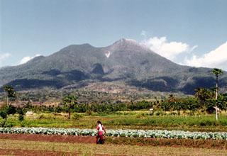
Egon
Indonesia
8.676°S, 122.455°E; summit elev. 1661 m
All times are local (unless otherwise noted)
This first Bulletin report discussing Egon describes the sudden appearance of volcanic activity there in January 2004. Heavy rains fell over Egon and its surrounding area on 28 January. At 0400 on 29 January, local people heard the sound of the E crater wall collapsing inward. That was followed at 1700 by an explosion and a black ash cloud rising ~ 750 m above the summit. On 30-31 January further noise was followed by gray ash clouds and the odor of highly concentrated sulfur every 50-60 minutes. Visual observation on 31 January revealed a new solfatara.
Volcanic earthquakes were detected on 30 January (intensity III on the Modified Mercali (MMI) scale), and a seismometer installed on 31 January recorded a type-A deep-volcanic earthquake at 1610 and two harmonic tremor events (amplitude 0.5 mm) at 1800. At 2227 an explosion was heard and instrumentally recorded for about 70 seconds. On 1 February, instruments recorded two tremor events and one type-A volcanic earthquake. Egon was placed on Alert level 3 (on a 1-4 scale) on that day.
United Nations reports and news reports from around 31 January indicated that up to 6,400 people were being evacuated from near Egon volcano as a precautionary measure due to "smoke," ash, and other possible emissions. The news cited evacuations from the mountain villages of Hale, Hebing, Lere, Natakoli, Pedat, Bau Krengat, and Kelawair, with refugees going to Maumere (the island's main town, 25 km W of the summit). There were reports of 1 or 2 deaths, but it is not entirely clear that they were related to volcanic activity, evacuations, or other causes.
The European Volcanological Society (SVE) posted this report on the UN's Relief Web website: "One person has been reported killed from smoke and ash inhalation from the eruption of Egon volcano. Thick clouds of smoke and a great discharge of hot ash, large chunks of sulfur and volcanic rocks were seen nearby. The eruption caused panic among residents nearby, and they fled the mountain villages . . . . Eyewitnesses said the lower part of the crater was seen bursting and that was believed to be the main outlet for the hot lava that spewed from the volcano.."
Agence France-Presse published a photo (by Romeo Gacad) with a distant aerial view of Egon's summit as it appeared around sunset on 1 February. A thin plume rose gently above the summit. Lower portions of the photo were in cloud.
A 2 February 2004 United Nations (OCHA) report stated that "Volcanologists continue monitoring the activity of Mt. Egon closely. Since the beginning of February, a decrease in seismic activity and emissions has been registered." This and another UN report noted, as of 13 February ~ 5,000 people had been evacuated and had been accommodated in 14 temporary government shelters. The report went on to note "A gradual return of the evacuated population has already begun and is expected to continue if current conditions remain unchanged. As of 4 February some 600 people have already returned to their villages."
Geological Summary. Gunung Egon, also known as Namang, sits within the narrow section of eastern Flores Island. The barren, sparsely vegetated summit region has a 350-m-wide, 200-m-deep crater that sometimes contains a lake. Other small crater lakes occur on the flanks. A lava dome forms the southern summit. Solfataric activity occurs on the crater wall and rim and on the upper S flank. Reports of eruptive activity prior to explosive eruptions beginning in 2004 are unconfirmed. Emissions were often observed above the summit during 1888-1892. Strong emissions in 1907 reported by Sapper (1917) was considered by the Catalog of Active Volcanoes of the World (Neumann van Padang, 1951) to be an historical eruption, but Kemmerling (1929) noted that this was likely confused with an eruption on the same date and time from Lewotobi Lakilaki.
Information Contacts: Dali Ahmad, Hetty Triastuty, Nia Haerani, and Suswati, Directorate of Volcanology and Geological Hazards (formerly VSI), Jalan Diponegoro No 57, Bandung 40122, Indonesia (URL: http://www.vsi.esdm.go.id/); Dan Shackelford, 3124 E. Yorba Linda Blvd., Apt. H-33, Fullerton, CA 92831-2324, USA; United Nations, Office for the Coordination of Humanitarian Affairs (UN OCHA), S-3600, New York, NY 10017, USA (URL: https://reliefweb.int/); Henry Gaudru, Société Volcanologique Européenne (SVE), C.P.1-1211 Geneva 17- Switzerland (URL: http://www.sveurop.org/).