Report on Colima (Mexico) — May 2004

Bulletin of the Global Volcanism Network, vol. 29, no. 5 (May 2004)
Managing Editor: Richard Wunderman.
Colima (Mexico) Small explosions reamed out the former dome but left surrounding center intact
Please cite this report as:
Global Volcanism Program, 2004. Report on Colima (Mexico) (Wunderman, R., ed.). Bulletin of the Global Volcanism Network, 29:5. Smithsonian Institution. https://doi.org/10.5479/si.GVP.BGVN200405-341040
Colima
Mexico
19.514°N, 103.62°W; summit elev. 3850 m
All times are local (unless otherwise noted)
A March 2004 observatory report noted that one year of explosive activity had passed, an interval that began in February 2003 after the termination of lava emission (BGVN 28:06). During March-May 2003 there was an increase in the number of small explosions. During the year, seismometers recorded ~ 1,500 small explosions (figure 68). After that, the frequency of explosions became stable, with 3-5 daily explosions (figures 69 and 70). Four relatively significant explosions occurred during 2003 on 17 July, on 2 and 28 August (BGVN 28:08), and on 15 November, although there was no change in the daily number of events.
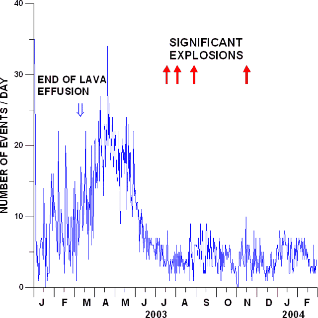 |
Figure 68. Daily variations in the number of small explosions recorded by the seismic network Red Sismica de Colima (RESCO) of Colima University from January 2003 to February 2004. The termination of the effusive stage is shown by the open arrow; four significant explosions are shown by filled arrows. Courtesy of Colima Volcano Observatory. |
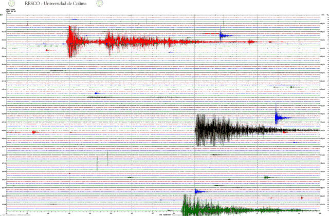 |
Figure 69. A typical daily seismogram with the records of small explosions (27 February 2004). RESCO seismic station Soma, at a distance of about 1.7 km from the crater. Courtesy of Colima Volcano Observatory. |
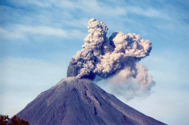 |
Figure 70. A typical view of a small explosion at Colima. Photo was taken on 1 February 2004. Courtesy of Colima Volcano Observatory. |
The sequence of explosions destroyed the former lava dome. Although the depth of the crater floor increased slightly as a result, the crater's dimensions changed little (figure 71).
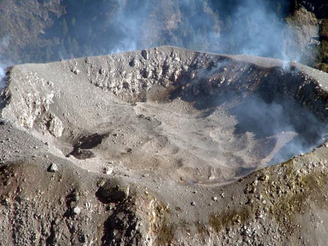 |
Figure 71. A view of Colima's crater floor from the S, taken on 27 February 2004. Courtesy of Colima Volcano Observatory. |
A later observatory report also noted that a significant explosion took place at 1228 on 12 June 2004. During preceding days, the volcano continued to show low-intensity activity, with an average of under three ash explosions per day. The heights of the columns did not exceed 2,000 m above the crater; they blew mainly to the W.
The exclusionary zone for both States adjoining Colima volcano remained 6.5 km from the summit. Also, the alert radius covered distances of up to 11.5 km from the summit, in order to include residents of Causentla, Cofradia de Tonila, Atenguillo, El Saucillo, El Fresnal, and El Embudo. Warnings to avoid lingering were also applied to the valleys of La Lumbre, El Cordobán, San Antonio and Monte Grande, El Muerto, La Tuna, Santa Ana, El Cafecito, La Arena, and Beltrán-Duranzno.
The Washington Volcanic Ash Advisory Center (VAAC) for aviation safety issued many reports ("Volcanic Ash Advisories") for Colima during 2003 and 2004, including over 30 during 2004. The bulk of the 2004 reports came out in February, March, April, and as recently as 14 May; no reports were issued since then to the late June date of this Bulletin. A sampling of the 2004 VAAC reports and associated graphics indicated several plumes to over 6 km altitude had been seen via satellite.
Geological Summary. The Colima complex is the most prominent volcanic center of the western Mexican Volcanic Belt. It consists of two southward-younging volcanoes, Nevado de Colima (the high point of the complex) on the north and the historically active Volcán de Colima at the south. A group of late-Pleistocene cinder cones is located on the floor of the Colima graben west and east of the complex. Volcán de Colima (also known as Volcán Fuego) is a youthful stratovolcano constructed within a 5-km-wide scarp, breached to the south, that has been the source of large debris avalanches. Major slope failures have occurred repeatedly from both the Nevado and Colima cones, producing thick debris-avalanche deposits on three sides of the complex. Frequent recorded eruptions date back to the 16th century. Occasional major explosive eruptions have destroyed the summit (most recently in 1913) and left a deep, steep-sided crater that was slowly refilled and then overtopped by lava dome growth.
Information Contacts: Observatorio Vulcanológico de la Universidad de Colima, Colima, Col., 28045, México; Washington Volcanic Ash Advisory Center (VAAC), NOAA-NESDES, Satellite Analysis Branch, 5200 Auth Road, Camp Springs, Maryland 20746 USA.