Report on Arenal (Costa Rica) — August 2004

Bulletin of the Global Volcanism Network, vol. 29, no. 8 (August 2004)
Managing Editor: Richard Wunderman.
Arenal (Costa Rica) Pyroclastic flows on 6 July generated by detached lavas
Please cite this report as:
Global Volcanism Program, 2004. Report on Arenal (Costa Rica) (Wunderman, R., ed.). Bulletin of the Global Volcanism Network, 29:8. Smithsonian Institution. https://doi.org/10.5479/si.GVP.BGVN200408-345033
Arenal
Costa Rica
10.463°N, 84.703°W; summit elev. 1670 m
All times are local (unless otherwise noted)
A sequence of pyroclastic flows moved down the N and NE flanks in September 2003 (BGVN 28:09). In general, Arenal's behavior during October 2003-March 2004 was similar to past years, with Crater C exhibiting ongoing gas emissions, lava flows, and sporadic Strombolian eruptions, and Crater D emitting fumarolic gases. The month with the highest number of inferred eruption earthquakes and the longest duration of tremor was March 2004 (table 23); long-period earthquakes spiked in May 2004.
Table 23. Seismic activity registered at Arenal's station VACR, October 2003-June 2004. From 24 June onward, the seismic station was out of service. Courtesy of OVSICORI-UNA.
| Month | Eruption earthquakes | Tremor (hours) | Long-period earthquakes |
| Oct 2003 | 997 | 521 | 16 |
| Nov 2003 | 724 | 468 | -- |
| Dec 2003 | -- | -- | -- |
| Jan 2004 | 910 | 610 | 10 |
| Feb 2004 | 896 | 639 | 8 |
| Mar 2004 | 1169 | 661 | 18 |
| Apr 2004 | 957 | 604 | 4 |
| May 2004 | 901 | 405 | 53 |
| Jun 2004 | 974 | 401 | -- |
Typical NE-flank lava flows persisted on 11 October 2003; in addition, some lava flows began to descend the SE flank, but they ceased by month's end. November 2003 reports noted NE-flank lava flows reaching 8 km NE of the edifice. There were a few October eruptions that produced columns of ash more than 500 m above Crater C's rim. During November lava flows persisted on the NE; some extended 8 km. During December 2003, tephra fell on both Crater C's NE and SE sides; acid rain was also noted.
On 12 March 2004 a hot avalanche occurred at the lava front progressing toward Arenal's NE side; the avalanche cascaded downslope and stopped at 850 m elevation. Near the crater's N edge some blocks fell and portions of that mass-wasting event reached vegetation. Eruptive activity declined but crevasses continue to widen. Small cold avalanches were also seen.
Pyroclastic flows on 6 July 2004. At 1319 on 6 July a series of pyroclastic flows descended the NE flank; other pyroclastic flows may have occurred later. Several medium-size pulses affected some patches of vegetation in the lower areas of the cone, ~ 900 m below the summit. The hot avalanches and airborne materials formed a plume of ash and dust blown SW. The pyroclastic flows resulted from the collapse of the upper areas of a lava flow, and impacted an area affected by flows during 1999-2003, but also invaded other areas. This type of phenomena has been common, particularly in recent years, to the N and NE. Figure 99 shows the distal portion of the area of pyroclastic-flow. Deposits included both abundant fine-grained materials and substantial blocks. Direct observations were hampered by the pyroclastic flows as well as cloud cover. Authorities temporarily closed routes around the volcano, but the area was within the National Park in a zone excluding visitors.
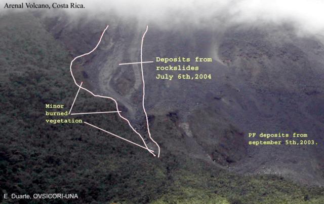 |
Figure 99. The lower portions of Arenal's 6 July 2004 pyroclastic-flow deposit, as outlined by OVSICORI-UNA scientists. Eliecer Duarte provided a rough estimate of distance from the middle left to the lower right side of the area (the 'heel to the tip of the toe') as 250 m. Locations of some of the burned and singed vegetation are indicated. Loose mass-wasted materials (labeled as deposits from rockslides) also accompanied the pyroclastic flows. Courtesy of OVSICORI-UNA. |
Geological Summary. Conical Volcán Arenal is the youngest stratovolcano in Costa Rica and one of its most active. The 1670-m-high andesitic volcano towers above the eastern shores of Lake Arenal, which has been enlarged by a hydroelectric project. Arenal lies along a volcanic chain that has migrated to the NW from the late-Pleistocene Los Perdidos lava domes through the Pleistocene-to-Holocene Chato volcano, which contains a 500-m-wide, lake-filled summit crater. The earliest known eruptions of Arenal took place about 7000 years ago, and it was active concurrently with Cerro Chato until the activity of Chato ended about 3500 years ago. Growth of Arenal has been characterized by periodic major explosive eruptions at several-hundred-year intervals and periods of lava effusion that armor the cone. An eruptive period that began with a major explosive eruption in 1968 ended in December 2010; continuous explosive activity accompanied by slow lava effusion and the occasional emission of pyroclastic flows characterized the eruption from vents at the summit and on the upper western flank.
Information Contacts: Observatorio Vulcanológico y Sismológico de Costa Rica, Universidad Nacional (OVSICORI-UNA), Apartado 86-3000, Heredia, Costa Rica. (URL: http://www.ovsicori.una.ac.cr).