Report on Awu (Indonesia) — October 2004
Bulletin of the Global Volcanism Network, vol. 29, no. 10 (October 2004)
Managing Editor: Richard Wunderman.
Awu (Indonesia) Volcanic seismicity ends in early August; weak plumes
Please cite this report as:
Global Volcanism Program, 2004. Report on Awu (Indonesia) (Wunderman, R., ed.). Bulletin of the Global Volcanism Network, 29:10. Smithsonian Institution. https://doi.org/10.5479/si.GVP.BGVN200410-267040
Awu
Indonesia
3.689°N, 125.447°E; summit elev. 1318 m
All times are local (unless otherwise noted)
Awu extruded a new dome in its crater by 2 June 2004 (BGVN 29:05). Several photos received from the Directorate of Volcanology and Geological Hazard Mitigation (DVGHM) taken from the crater's upper S side illustrate the crater prior to and just after the 2004 dome emplacement (figures 4-6). Elevated seismicity continued into the week ending on 8 August 2004 (table 2). During 12-25 July, observers saw white thin-medium plumes gently rising to 50 m above the summit. A report covering 9-15 August, noted that the Awu observation post documented a weak plume 200 m tall. They also reported nine type-B earthquakes. A brief message from DVGHM on 7 December noted that Awu was then quiet.
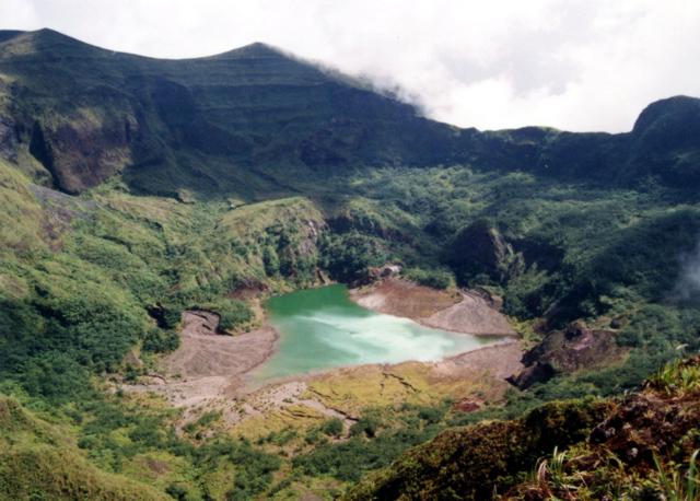 |
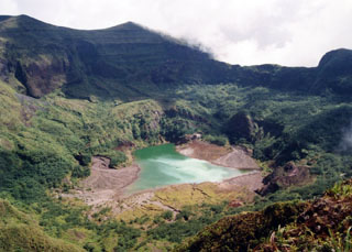
Figure 4. A N-looking photo of the Awu's crater taken in September 1995. Note the large ephemeral pond on the crater floor. Courtesy of DVGHM; photo by Kristianto. |
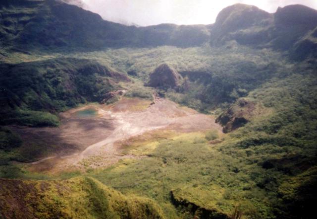 |
Figure 5. A N-looking photo from 25 May 2003 showing the active crater at Awu. Compared to the photo from 1995 (figure 7, above), the pond on the crater floor had shrunken. A photo from 8 December 2002 (not included in this report) showed that at that time the pond was largely gone. Courtesy of DVGHM; photo by Endi T. Bina. |
 |
Figure 6. A N-looking photo of Awu's crater on 14 June 2004 showing the newly emplaced intra-crater dome and associated deposits. Disruption in the crater is also apparent, for example, the burial and heavy damage to vegetation . Thick steam made it difficult to see the distinctive rim on the crater's far side. Courtesy of DVGHM; photo by Agus Solihin. |
Table 2. Summary of volcanic type-A earthquakes and tectonic earthquakes at Awu during 22 June through 15 August 2004. Volcanic type-B volcanic earthquakes also occurred occasionally, perhaps once a week, except in the 9-15 August interval, when they occurred nine times. Data for several days and time intervals (eg., 6 and 11 July, and 26 July-1 August) was not available. Courtesy of DVGHM.
| Date | Deep Volcanic (A-type) | Tectonic |
| 22 Jun-28 Jun 2004 | 5 | 84 |
| 29 Jun-05 Jul 2004 | 6 | 74 |
| 07 Jul-12 Jul 2004 | 3 | 93 |
| 13 Jul-18 Jul 2004 | 2 | 74 |
| 19 Jul-25 Jul 2004 | 25 | 110 |
| 26 Jul-01 Aug 2004 | -- | -- |
| 02 Aug-08 Aug 2004 | 7 | 92 |
| 09 Aug-15 Aug 2004 | 0 | 75 |
Aviation reports. The Volcanic Ash Advisory Centre at Darwin, Australia, issued 15 reports (Volcanic Ash Advisories) regarding Awu during June 2004. These were the first and only Awu reports available in their archive of reports going back to 1998. The first message (on 8 June) was "Major eruption possible, but no eruption yet." Similar terminology accompanied Advisories until 12 June. The 9 June report noted "continuous small eruptions" and "four larger explosions in past two days." A plume also seen on satellite imagery was estimated by pilots to be at ~ 4.5-6 km. Later it became difficult to see the plume with satellite imagery. On 10 June two Advisories noted thin plumes directed NE extending ~ 37 km. The plumes were seen on imagery at 2325 and 0220 UTC (in aerospace shorthand, the imagery came from DVGHM, DMSP, GOES, and NOAA 17 satellites). The final Advisory, on 14 June, noted "Eruption details: Nil obs[erved] ash." That notice also commented that the alert status had dropped and no significant activity had been recorded, but a white plume rose ~ 100 m above the summit in the last 24 hours.
Geological Summary. The massive Gunung Awu stratovolcano occupies the northern end of Great Sangihe Island, the largest of the Sangihe arc. Deep valleys that form passageways for lahars dissect the flanks of the volcano, which was constructed within a 4.5-km-wide caldera. Powerful explosive eruptions in 1711, 1812, 1856, 1892, and 1966 produced devastating pyroclastic flows and lahars that caused more than 8000 cumulative fatalities. Awu contained a summit crater lake that was 1 km wide and 172 m deep in 1922, but was largely ejected during the 1966 eruption.
Information Contacts: Dali Ahmad, Volcanological Survey of Indonesia (VSI), Directorate of Volcanology and Geological Hazard Mitigation, Jalan Diponegoro 57, Bandung 40122, Indonesia (URL: http://www.vsi.esdm.go.id/); Office for the Coordination of Humanitarian Affairs (OCHA), United Nations, New York, NY 10017, USA; Darwin Volcanic Ash Advisory Centre (VAAC), Bureau of Meteorology, Northern Territory Regional Office, PO Box 40050, Casuarina, NT 0811, Australia (URL: http://www.bom.gov.au/info/vaac/).