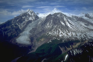
Report on Spurr (United States) — October 2004
Bulletin of the Global Volcanism Network, vol. 29, no. 10 (October 2004)
Managing Editor: Richard Wunderman.
Spurr (United States) Elevated seismicity, increased carbon dioxide emissions, and melting of the ice cap
Please cite this report as:
Global Volcanism Program, 2004. Report on Spurr (United States) (Wunderman, R., ed.). Bulletin of the Global Volcanism Network, 29:10. Smithsonian Institution. https://doi.org/10.5479/si.GVP.BGVN200410-313040
Spurr
United States
61.299°N, 152.251°W; summit elev. 3374 m
All times are local (unless otherwise noted)
Spurr, ~ 125 km W of Anchorage across Cook Inlet, became restless in recent months. This activity consisted of increased seismicity beginning in February 2004, melting of the summit ice cap, and substantial emission rates of carbon dioxide (CO2) and sulfur dioxide (SO2). Scientists at the Alaska Volcano Observatory (AVO) recorded hundreds of small earthquakes centered 4.8-6.4 km beneath the summit. Elevated levels of seismicity continued through early November 2004 (table 2). Although the rate of seismicity is greater than typical background levels, AVO has found no indication that an eruption is imminent.
Table 2. Weekly seismicity within 30 km of the summit at Spurr, with magnitudes over 1.5 and depths of 1-6 km. Courtesy of AVO.
| Dates | Average earthquakes per day |
| 24 Jul-30 Jul 2004 | 10-20 |
| 31 Jul-06 Aug 2004 | 10-20 |
| 07 Aug-13 Aug 2004 | 10-20 |
| 14 Aug-20 Aug 2004 | 15 (70 events on 14 Aug) |
| 21 Aug-27 Aug 2004 | 12 |
| 28 Aug-03 Sep 2004 | 14 |
| 04 Sep-10 Sep 2004 | 13 |
| 11 Sep-17 Sep 2004 | 12 |
| 18 Sep-24 Sep 2004 | 10 |
| 25 Sep-01 Oct 2004 | 13 |
| 02 Oct-08 Oct 2004 | 8 |
| 09 Oct-15 Oct 2004 | 9 |
| 16 Oct-22 Oct 2004 | 2-14 |
| 23 Oct-29 Oct 2004 | 12-24 (3 per hour on 26 Oct) |
| 30 Oct-05 Nov 2004 | 0-24 (10 per hour on 4 Nov) |
Aerial reconnaissance in mid-July and early August documented recent small flows of mud and rock and a depression in the icecap (an "ice cauldron") just NE of the summit that was ~ 50 x 75 m in size and ~ 25 m deep. The floor of the depression contained an icy pond, with small areas of open water. No steam or volcanic emissions were observed. The ice cauldron is a collapse feature possibly caused by an increase in heat coming from deep beneath the summit. Using sensitive instruments, scientists flying around the volcano on 7 August detected small amounts of the volcanic gases in a plume from the summit.
Observations and photography during the week ending 10 September revealed that the ice cauldron had enlarged substantially (to ~ 150 x 170 m), presumably as the roof of the meltwater basin continued to subside and collapse. AVO scientists measured gases being emitted by the summit vent and Crater Peak, a flank vent, during a fixed-wing flight on 15 September 2004. The combined output of CO2 from the two vents was ~ 2,300 tons/day, an increase from the ~ 760 tons/day measured 7-8 August 2004. The gray color of the lake at the bottom of the ice cauldron is typical of crater lakes containing dissolved SO2.
AVO staff took an overflight of the volcano on 18 October and reported that the summit ice cauldron persisted without appreciable change of its geometry or of the surrounding crevasses. The ice cauldron continued to contain standing water, no steam or sulfur scent was observed from the summit, and steam issuing from Crater Peak had not changed from previous observations.
References. Power, J., 2004, Renewed unrest at Mount Spurr Volcano, Alaska: Eos (Transactions, American Geophysical Union), v. 85, no. 43, p. 2.
Waythomas, C.F., and Nye, C.J., 2002, Preliminary volcano-hazard assessment for Mount Spurr Volcano, Alaska: U.S. Geological Survey Open-File Report 01.482, Alaska Volcano Observatory, Anchorage, Alaska, 39 pp.
Geological Summary. Mount Spurr is the closest volcano to Anchorage, Alaska (130 km W) and just NE of Chakachamna Lake. The summit is a large lava dome at the center of a roughly 5-km-wide amphitheater open to the south formed by a late-Pleistocene or early Holocene debris avalanche and associated pyroclastic flows that destroyed an older edifice. The debris avalanche traveled more than 25 km SE, and the resulting deposit contains blocks as large as 100 m in diameter. Several ice-carved post-collapse cones or lava domes are present. The youngest vent, Crater Peak, formed at the southern end of the amphitheater and has been the source of about 40 identified Holocene tephra layers. Eruptions from Crater Peak in 1953 and 1992 deposited ash in Anchorage.
Information Contacts: U.S. Geological Survey Alaska Volcano Observatory (AVO), a cooperative program of the USGS, University of Alaska Fairbanks Geophysical Institute, and the Alaska Division of Geological and Geophysical Surveys (URL: http://www.avo.alaska.edu/).

