Report on Mayon (Philippines) — December 2004
Bulletin of the Global Volcanism Network, vol. 29, no. 12 (December 2004)
Managing Editor: Richard Wunderman.
Mayon (Philippines) Minor activity in June, July, and September 2004; reported ash emission
Please cite this report as:
Global Volcanism Program, 2004. Report on Mayon (Philippines) (Wunderman, R., ed.). Bulletin of the Global Volcanism Network, 29:12. Smithsonian Institution. https://doi.org/10.5479/si.GVP.BGVN200412-273030
Mayon
Philippines
13.257°N, 123.685°E; summit elev. 2462 m
All times are local (unless otherwise noted)
An explosion-type volcanic earthquake detected by the Upper Anoling seismic station on the afternoon of 3 June 2004 was not visually observed due to thick clouds covering the summit. Residents closer to the Upper Anoling Seismic Station and Mayon Resthouse did not notice any unusual activity. No traces of ash or changes in the crater wall were observed. Sulfur dioxide (SO2) emission rose from 1,169 metric tons/day (t/d) on 12 May to 2,521 t/d on 4 June, then decreased to 1,514 t/d on 18 June. Precise leveling measurements showed a slight but deflation of the edifice. The number of low-frequency volcanic earthquakes and low-frequency short-duration harmonic tremors increased in June to almost twice the number recorded in May. In addition, faint crater glow continued to be observed at the summit, as it had since 7 October 2003.
Another explosion was recorded on 22 July 2004. According to news reports, ash from that event was deposited in two local villages.
Sulfur dioxide (SO2) emissions remained only slightly above baseline at 829 metric tons per day as of 6 September 2004. On the evening of 12 September 2004 the very faint glow at the summit of Mayon intensified slightly. The brighter incandescence, observable from Lignon Hill Volcano Observatory and in Legaspi City proper, coincided with a slight increase in the overall background tremor detected by seismographs around the volcano. However, there were no significant changes in ground deformation or SO2 measurements. A news report also noted that volcanic material emitted from the crater that day set fire to grass on the volcano's slopes.
The hazard status remained at Alert Level 2, indicating a low level of volcanism. PHIVOLCS reminded the public to refrain from venturing into the 6-km Permanent Danger Zone because life-threatening volcanic flows may occur with little or no warning.
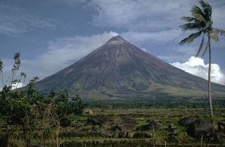
Geological Summary. Symmetrical Mayon, which rises above the Albay Gulf NW of Legazpi City, is the most active volcano of the Philippines. The steep upper slopes are capped by a small summit crater. Recorded eruptions since 1616 CE range from Strombolian to basaltic Plinian, with cyclical activity beginning with basaltic eruptions, followed by longer periods of andesitic lava flows. Eruptions occur predominately from the central conduit and have also produced lava flows that travel far down the flanks. Pyroclastic density currents and mudflows have commonly swept down many of the approximately 40 ravines that radiate from the summit and have often damaged populated lowland areas. A violent eruption in 1814 killed more than 1,200 people and devastated several towns.
Information Contacts: Philippine Institute of Volcanology and Seismology (PHIVOLCS), Department of Science and Technology, PHIVOLCS Building, C.P. Garcia Avenue, Univ. of the Philippines Campus, Diliman, Quezon City, Philippines (URL: http://www.phivolcs.dost.gov.ph/); Associated Press (URL: http://www.ap.org/); The Australian (URL: http://www.theAustralian.news.com.au/).

