Report on Rinjani (Indonesia) — February 2005
Bulletin of the Global Volcanism Network, vol. 30, no. 2 (February 2005)
Managing Editor: Richard Wunderman.
Rinjani (Indonesia) Witnessed eruptions in October 2004 with material escaping from two vents
Please cite this report as:
Global Volcanism Program, 2005. Report on Rinjani (Indonesia) (Wunderman, R., ed.). Bulletin of the Global Volcanism Network, 30:2. Smithsonian Institution. https://doi.org/10.5479/si.GVP.BGVN200502-264030
Rinjani
Indonesia
8.42°S, 116.47°E; summit elev. 3726 m
All times are local (unless otherwise noted)
Rinjani had increases in some monitored parameters and hazard status during this report interval, covering much of 2004 through 30 January 2005. An eruption occurred on 1 October 2004. We previously presented a brief aviation report concerning an unconfirmed ash cloud from Rinjani in September 1995 (BGVN 20:10). In their text associated with recent reporting used here, The Directorate of Volcanology and Geological Hazard Mitigation (DVGHM) noted that Rinjani's last explosions occurred during 4 June 1994-January 1995. Those explosions came from Barujari volcano (see Background for morphologic information).
On 27 September 2004 a DVGHM report noted the decision to increase Rinjani's hazard status to Alert Level II (Yellow, on a scale with the most hazardous at IV). During the last third of 2004, the number of volcanic and tectonic earthquakes had increased. Their increase followed a rise in the number of tectonic earthquakes that began 18 August 2004. Tremor registered on 23, 24, 25, and 26 September 2004. Tremor amplitudes ranged between 12 and 13.5 mm, and the duration of the tremor stood between 94 and 290 seconds.
At 0530 on 1 October 2004 Rinjani clearly erupted. The observation station where visual monitoring occurs (Sembalun Lawang) lies in a spot where the caldera wall blocks views into the active zone, so a smaller eruption might have been missed. The eruption caused authorities to immediately raise the hazard status to Alert Level III (Orange). Further details have not emerged regarding the initial 1 October eruption. During the next few days of eruptions, the lake Segara Anak remained undisturbed.
During 2-5 October 2004 continued explosions sent ash columns ~ 300 to 800 m above the summit. Gray, thick ash columns drifted to the N. Detonation sounds accompanied every explosion. Successive explosions occurred at intervals of 5 to 160 minutes. Explosions vented on the NE slope of Barujari volcano. Some material also vented from Barujari's peak, however, and fell down around its edifice. A press report in the Jakarta Post indicated that evacuations were not considered necessary.
Available monthly seismic data appears in table 2. Seismicity was dominated by explosion earthquakes with maximum amplitudes of 30 mm. Explosion and emission signals were common during February and March 2004 and became absent or unreported after April 2004. Data were unavailable for October 2004 when known eruptions occurred.
Table 2. Available seismicity at Rinjani during 10 February 2004 to 30 January 2005. The symbol " - " means not reported. Courtesy of VSI.
| Date | Volcanic A | Volcanic B | Tremor | Emission | Explosion |
| 10 Feb 2004 | 2 | -- | 20 | 3 | 37 |
| 10 Mar 2004 | 3 | 3 | 16 | 5 | 32 |
| 10 Apr 2004 | -- | -- | 5 | -- | 5 |
| 17-23 Jan 2005 | 20 | 28 | 11 | -- | -- |
| 24-30 Jan 2005 | 9 | 34 | 11 | -- | -- |
During 24 to 30 January 2005, gas plumes remained less than 600 m tall. The tremor record had a maximum amplitude of 1.5 mm.
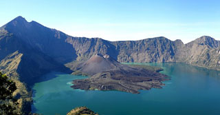
Geological Summary. Rinjani volcano on the island of Lombok rises to 3726 m, second in height among Indonesian volcanoes only to Sumatra's Kerinci volcano. Rinjani has a steep-sided conical profile when viewed from the east, but the west side of the compound volcano is truncated by the 6 x 8.5 km, oval-shaped Segara Anak (Samalas) caldera. The caldera formed during one of the largest Holocene eruptions globally in 1257 CE, which truncated Samalas stratovolcano. The western half of the caldera contains a 230-m-deep lake whose crescentic form results from growth of the post-caldera cone Barujari at the east end of the caldera. Historical eruptions dating back to 1847 have been restricted to Barujari cone and consist of moderate explosive activity and occasional lava flows that have entered Segara Anak lake.
Information Contacts: Directorate of Volcanology and Geological Hazard Mitigation (DVGHM), Jalan Diponegoro 57, Bandung 40122, Indonesia (URL: http://www.vsi.esdm.go.id/); The Jakarta Post, Indonesia (URL: http://www.thejakartapost.com/).