Report on Langila (Papua New Guinea) — May 2005

Bulletin of the Global Volcanism Network, vol. 30, no. 5 (May 2005)
Managing Editor: Richard Wunderman.
Langila (Papua New Guinea) Ash emissions and lava flow during April-June 2005
Please cite this report as:
Global Volcanism Program, 2005. Report on Langila (Papua New Guinea) (Wunderman, R., ed.). Bulletin of the Global Volcanism Network, 30:5. Smithsonian Institution. https://doi.org/10.5479/si.GVP.BGVN200505-252010
Langila
Papua New Guinea
5.525°S, 148.42°E; summit elev. 1330 m
All times are local (unless otherwise noted)
Langila was last reported on in BGVN 29:06, as part of a MODIS data summary, although the last prominent event there was on 18 January 2003, when a large explosion produced a thick dark ash column that penetrated the weather clouds over the summit area (BGVN 28:03).
A plume from Langila was visible on satellite imagery on 17 December 2004 according to the Darwin VAAC. The plume reached an unknown height and extended NW.
Between 28 April 2005 and 4 May 2005 the Rabaul Volcano Observatory (RVO) received reports of activity at Langila characterized by forceful emissions of thick white to gray ash-laden clouds rising ~ 700-800 m above the summit crater. Occasional continuous rumbling and explosive noises were heard and incandescence was visible at night. During early May, incandescent lava fragments were ejected. Activity increased at about 1300 on 4 May 2005, when white-to-gray ash emissions changed to dark ash clouds. Explosions became frequent, with incandescent lava fragments ejected again, and very bright glow was visible during the night. Around 1200 on 5 May 2005 the color of the ash emissions changed from dark gray to white-to-gray. A lava flow was produced but no further detail is available. Based on information from RVO, the Darwin VAAC reported that ash emissions from Langila rose to ~ 2.1 km altitude on 3 May. A very small plume and a hot spot were visible on satellite imagery. Ash clouds from the eruption were blown generally NW towards Kilenge ~ 100 km away, where light to moderate ashfall was reported.
According to the Darwin VAAC, low-level ash plumes emitted from Langila were visible on satellite imagery during 8-13 June 2005. RVO reported to the Darwin VAAC that moderate eruptive activity was expected to continue.
The International Federation of Red Cross and Red Crescent Societies (IFRC) reported that eruptive activity occurred at Langila on 2 June with more ash than normal being emitted from the volcano. Prevailing winds carried most of the initial ashfall to the sea, but lower-level winds redirected the ash back onto the island. About 10,000 people live near the volcano, and there were reports of increased cases of respiratory problems and eye irritation. During an aerial inspection of the area on 6 June 2005, IFRC determined that ~ 3,490 people had been affected by the eruption, mainly in the villages of Aitavala, Masele, Kilenge, Ongaea, Potne, and Sumel, but also to a lesser extent in Vem, Galegale, Tauale, and Laut. Ashfall damaged small food gardens and contaminated some water sources. The provincial government encouraged voluntary evacuation of affected areas.
During 16-17 June 2005, ash plumes from Langila were visible on satellite imagery (figure 4). The heights of the plumes were not reported.
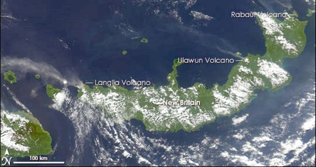 |
Figure 4. On 21 June 2005 the Moderate Resolution Imaging Spectroradiometer (MODIS), flying on NASA's Aqua satellite, captured this image of Langila, Ulawun, and Rabaul. At the time MODIS captured this image, Langila showed the biggest plume of volcanic ash, followed by Ulawun. In all cases, winds pushed the ash clouds NW over the ocean. NASA image courtesy Jesse Allen, based on data from the MODIS Rapid Response Team at NASA. |
Geological Summary. Langila, one of the most active volcanoes of New Britain, consists of a group of four small overlapping composite basaltic-andesitic cones on the lower E flank of the extinct Talawe volcano in the Cape Gloucester area of NW New Britain. A rectangular, 2.5-km-long crater is breached widely to the SE; Langila was constructed NE of the breached crater of Talawe. An extensive lava field reaches the coast on the N and NE sides of Langila. Frequent mild-to-moderate explosive eruptions, sometimes accompanied by lava flows, have been recorded since the 19th century from three active craters at the summit. The youngest and smallest crater (no. 3 crater) was formed in 1960 and has a diameter of 150 m.
Information Contacts: Darwin Volcanic Ash Advisory Centre (VAAC), Bureau of Meteorology, Northern Territory Regional Office, PO Box 40050, Casuarina, Northern Territory 0811, Australia (URL: http://www.bom.gov.au/info/vaac/); Rabaul Volcano Observatory (RVO), P.O. Box 386, Rabaul, Papua New Guinea; International Federation of Red Cross And Red Crescent Societies (IFRC), Langila Volcano Information Bulletin No. 1 (URL: https://reliefweb.int/).