Report on Barren Island (India) — May 2005

Bulletin of the Global Volcanism Network, vol. 30, no. 5 (May 2005)
Managing Editor: Richard Wunderman.
Barren Island (India) Lava flow and ash discharges seen by Coast Guard personnel on 28 May 2005
Please cite this report as:
Global Volcanism Program, 2005. Report on Barren Island (India) (Wunderman, R., ed.). Bulletin of the Global Volcanism Network, 30:5. Smithsonian Institution. https://doi.org/10.5479/si.GVP.BGVN200505-260010
Barren Island
India
12.278°N, 93.858°E; summit elev. 354 m
All times are local (unless otherwise noted)
Members of the Indian Coast Guard observed a new eruption on the morning of 28 May 2005. An ash plume originated from a vent on the W side of the summit of the central cone; fresh black lava flows did not reach the sea (figure 10). The eruption continued through at least 6 June. Fresh lava emissions had been noted by Indian Coast Guard personnel who patrol the area regularly. A large amount of steam was emitted due to heavy rainfall onto the hot lava surfaces. Heavy monsoon rains prevented access to the island. However, the Geological Survey of India (GSI) was planning a monitoring program and field expedition to the island.
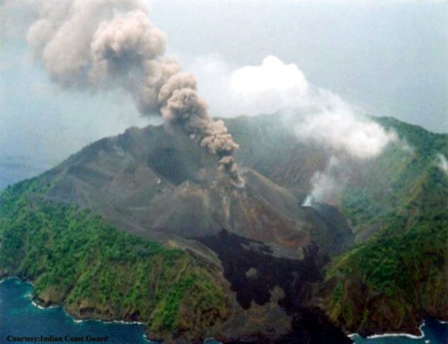 |
Figure 10. Photograph of Barren Island erupting on 28 May 2005 taken from a helicopter. The black lava in the foreground is of 1994-95 eruption. A lava flow that did not reach the sea issues from a steaming flank vent. View is towards the ESE. Courtesy of the Indian Coast Guard. |
Dornadula Chandrasekharam (Indian Institute of Technology) noted on 6 July that by that date the eruption had ceased, with only steam emissions continuing after three weeks of heavy monsoon rains. The Indian Coast Guard also confirmed to Chandrasekharam that the eruption was first noticed on 28 May, contrary to some press reports indicating that activity was seen on the 27th. Patrol helicopters saw no activity on 25 and 26 May, and did not observe the island on the 27th.
Press reports. A report in the 31 May edition of The Hindu stated that defense forces witnessed intermittent billowing smoke and "flame" from the volcano. The same article referenced a Press Trust of India (PTI) report that military forces that landed on the island "experienced a hot breeze and found themselves stepping on fresh lava" where earlier patrol teams had been able to reach the crater. Another article from The Hindu reported that on 2 June teams of the Indian Coast Guard vessel CG Sagar landed on the island in an inflatable raft while a helicopter hovered overhead. The report described eruptive activity consisting of lava and "fireballs" from the crater every few seconds. The purpose of the expedition was to "collect samples of the lava flowing into the rough sea" that would be given to scientists. Coast Guard members and various other government officials made an aerial survey of the island on 3 June according to a PTI report published in The Hindu the next day. The Lt. Governor of Andaman, Ram Kapse, saw "smoke and lava rising from the crater." Coast Guard sources stated that the volume of "smoke" had increased and lava was still flowing out of the crater.
A report in The Daily Telegrams on 17 February 2005 quoted K.N. Mathur, Director General of the GSI, regarding a scientific visit to Barren Island on 16 February. At that time, Mathur noted, the team observed "no serious volcanic activities on the island." A similar report in the 18 February edition of the Trinity Mirror carried a quote from Mathur that "There is no activity in the crater and it remained as it was found during GSI's last visit in 2003." These media reports were reproduced on the GSI website.
Geological Summary. Barren Island, a possession of India in the Andaman Sea about 135 km NE of Port Blair in the Andaman Islands, is the only historically active volcano along the N-S volcanic arc extending between Sumatra and Burma (Myanmar). It is the emergent summit of a volcano that rises from a depth of about 2250 m. The small, uninhabited 3-km-wide island contains a roughly 2-km-wide caldera with walls 250-350 m high. The caldera, which is open to the sea on the west, was created during a major explosive eruption in the late Pleistocene that produced pyroclastic-flow and -surge deposits. Historical eruptions have changed the morphology of the pyroclastic cone in the center of the caldera, and lava flows that fill much of the caldera floor have reached the sea along the western coast.
Information Contacts: Dornadula Chandrasekharam, Department of Earth Sciences, Centre of Studies in Resources Engineering, Indian Institute of Technology, Bombay 400076, India (URL: http://www.geos.iitb.ac.in/index.php/dc); Geological Survey of India, 27 Jawaharlal Nehru road, Kolkata 700016, India (URL: https://www.gsi.gov.in/); The Daily Telegrams, India; Trinity Mirror, Chennai, India; The Hindu, 859 and 860 Anna Salai, Chennai 600002, Tamil Nadu, India (URL: http://www.hinduonnet.com/); Press Trust of India, PTI Building, 4, Parliament Street, New Delhi 110001, India (URL: http://www.ptinews.com/); Indian Coast Guard, National Stadium Complex, New Delhi 110 001, India.