Report on Reventador (Ecuador) — May 2005

Bulletin of the Global Volcanism Network, vol. 30, no. 5 (May 2005)
Managing Editor: Richard Wunderman.
Reventador (Ecuador) Lava flow reaches 4 km from summit, approaching road and petroleum pipeline
Please cite this report as:
Global Volcanism Program, 2005. Report on Reventador (Ecuador) (Wunderman, R., ed.). Bulletin of the Global Volcanism Network, 30:5. Smithsonian Institution. https://doi.org/10.5479/si.GVP.BGVN200505-352010
Reventador
Ecuador
0.077°S, 77.656°W; summit elev. 3562 m
All times are local (unless otherwise noted)
Crisis escalates. Instituto Geofísico (IG) members noted that eruptions at Reventador in Ecuador's eastern cordillera continued into at least early July 2005. Observers documented thick blocky lava flows, occasional Vulcanian explosions, new fumarolic activity on the N flank of the cone, and venting of vapor, gases, and fine ash. This followed a spate of increased seismicity during April to early June 2005. Lava flows had extended 4 km from the summit vent toward the SE, in the direction of the main highway across this region, a route that links the important oilfields in the Amazon basin with Quito, the capital. The lava flows were sequentially numbered (Lava ##3, ##4, etc.).
Lava ##3, a flow that began in November 2004 (BGVN 29:11), advanced slowly and ceased movement by early January 2005. Following relatively low seismic activity in late 2004 and early 2005, the IG monitoring network began to register bands of harmonic tremor starting 1 April (figure 18). Through 8 April 2005, instruments recorded 45 tremor episodes, each lasting 10 to 60 minutes. Dominant frequency peaks were between 1 and 1.5 Hz. Given that strong incandescence was observed by a guard of PetroEcuador from 14 km away, the tremor was interpreted to signal the rise of magma into the upper part of the cone through an open conduit.
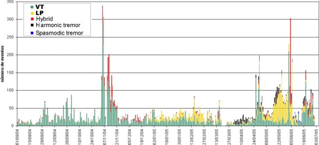 |
Figure 18. Seismic events registered at Reventador since August 2004. Courtesy of IG. |
Lava ##4 erupted coincident with this strong tremor and was the most important surface manifestation. It was first observed in an overflight on 12 April, escaping from a summit crater conduit that had formed a carapace. It was seen flowing down the SW crater notch onto the cone's flanks and then onto the SW and SE caldera floor. The flow partially covered Lava ##3 (figure 19), resulting in layers of recent lava in some places reaching more than 50 m thick. This emplacement was observed during several days of work on the seismic instrumentation and sampling within the caldera carried out by IG personnel during 19-22 April. During the same overflights, a new fumarole field was observed on the lower S flank of the cone, a spot very close to the upper Reventador River, in the same place where thermal anomalies were observed on 11 March 2005.
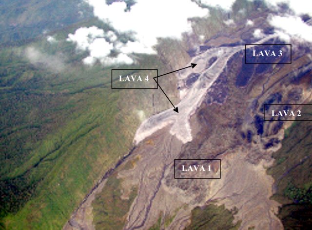 |
Figure 19. Location of lava flows related to eruptive activity within the Reventador caldera since 2002. Photo taken looking at the SE flank on 6 May 2005 by P. Ramón. Provided courtesy of IG. |
Starting on 15 May there was an important increase in the intensity of harmonic tremor, often preceded by low frequency (< 1 Hz) long-period events, a conspicuous aspect of behavior that was absent in April. Many of the long-period events, particularly those occurring during 17-21 May, were of such magnitude that they registered at seismic stations on other volcanoes (e.g., Cerro Negro and Guagua Pichincha) more than 100 km distant.After this elevated activity in mid May, there was a decrease in the number of events, dropping to an average of 88 per day. During this period Lava ##4 continued to flow, moving at the rate of about 20 m/day, advancing particularly strongly along the caldera's S wall in a stream channel (Rió Marker) cut through the 2002 pyroclastic deposits. Lava reached 25 meters thick when seen during a 22-23 May visit, during which time strong roars and the sounds of 'many jet planes' blared from the vent. These sounds indicated a strong gas flux, although little vapor was observed. At this time, there was an absence of both explosions and incandescence in the summit crater.
An overflight on 25 May confirmed the emergence of a new flow (Lava ##5). It followed the same route as ##4, but was comprised of three principal lobes. The middle lobe, which represented the most conspicuous and largest volume, advanced down the Río Marker's channel (figure 20).
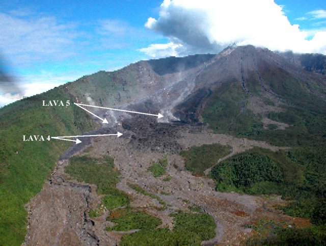 |
Figure 20. Lavas 4 and 5 flowing down the Marker's stream channel along the SE margin of Reventador's caldera. Photo taken on 17 June 2005 by P. Ramón. Provided courtesy of IG. |
Reventador's activity in June 2005 began with an important swarm of volcano-tectonic and hybrid seismic events—starting on the 2nd and continuing through the 3rd. Of particular note, tremor continued for more than 10 hours, and provided background to the discrete volcano-tectonic and hybrid events Hybrid events had not been registered since November 2004. Following these important swarms, instruments registered strong, full-amplitude bands of spasmodic tremor, comprised to some extent by packages of long-period events lasting for hours to days on end.
During these early days of June, there was an intensification of incandescence in the crater and later, the emission of gases and slight ash. On 8 June, a 100 km long vapor/ash column extended from the volcano into the S part of Quito at ~ 7 km altitude and caused a very slight powdering of ash, which was brought down by a gentle rain and left cars dappled with circular spots.
A trip by IG volcanologists into the caldera on 11-12 June disclosed strong Strombolian fountaining in the summit crater. Lava ##5 continued to flow atop the stalled Lava ##4. Measurements of SO2 flux with a mini-DOAS (differential optical absorption spectroscopy) resulted in an estimate of ~ 2,500 metric tons/day.
Three other seismic stations were installed around the caldera with the helicopter help of the petroleum company OCP during 16-19 June. One broad-band seismograph and infrasound system was also installed, thanks to collaboration with Jeff Johnson of the University of New Hampshire. During this period no Strombolian activity was observed, but Vulcanian explosions (figure 21) occurred with little warning. A 24-hour period during 18-19 June included at least seven discrete explosions, producing strong infrasound and seismic responses. Many of these explosions discharged columns that rose 2-3 km above the summit (and some, up to as high as ~ 6 km above the summit) and were clearly heard within the caldera. Large incandescent blocks could be seen thrown several hundreds of meters into the air, falling on the cone's upper slopes. Ash content in the columns was moderate. Explosions were discrete and often terminated within 4 minutes. Thermal alerts were identified by the Hawaii Institute of Geophysics and Planetology (HIGP). Observations on 30 June and 1 July noted recent lava flows in the upper Marker river valley (figure 22).
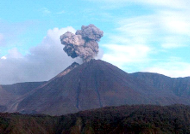 |
Figure 21. One of Reventador's discrete Vulcanian explosions observed during a 19 June 2005 helicopter flight. The view is from the E of Reventador caldera looking toward the W. Photo taken on by P. Ramón; provided courtesy of IG. |
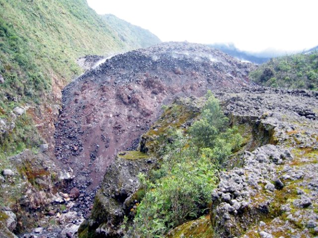 |
Figure 22. A photo of Reventador's Lava ##4 flow front (which had reddish hues) overtopped by Lava ##5 (more nearly white). The shot was taken in the Río Marker at 1100 on 30 June 2005. By 1 July, Lava ##5 had still not advanced beyond the terminus of Lava ##4. Photo by P. Ramón, provided courtesy of IG. |
The 4-6 discrete explosive degassing events/day observed in June led the IG authors to surmise that there were a series of temporary plugs in the upper part of the conduit. This behavior was thought to reflect magma becoming more crystal rich.
As of 6 July, harmonic tremor, occasional explosions, and long-period and volcano-tectonic signals all continued to register at Reventador on the IG's telemetered monitoring network. Strong Strombolian fountaining was observed from distances of 6.5 and 14 km during the evening and one of the lobes of Lava ##5 was advancing down the caldera wall (following the Río Marker), but abruptly slowed to perhaps only ~ 20 m/day. In comparison, this flow-front velocity had earlier attained ~ 70 m/day (during 19-23 June) and ~ 50 m/day (during 23-30 June). The diminished rate of advance and continuing high-amplitude tremor suggested that perhaps a new lava flow (Lava ##6) had broken out high on the flanks, a conjecture yet to be confirmed by press time. Lava ##5 was still 1.2 km from the steep incline, a point where it could begin rapid descent to the alluvial fan where the highway and petroleum pipeline are located.
Geological Summary. Volcán El Reventador is the most frequently active of a chain of Ecuadorian volcanoes in the Cordillera Real, well east of the principal volcanic axis. The forested, dominantly andesitic stratovolcano has 4-km-wide avalanche scarp open to the E formed by edifice collapse. A young, unvegetated, cone rises from the amphitheater floor to a height comparable to the rim. It has been the source of numerous lava flows as well as explosive eruptions visible from Quito, about 90 km ESE. Frequent lahars in this region of heavy rainfall have left extensive deposits on the scarp slope. The largest recorded eruption took place in 2002, producing a 17-km-high eruption column, pyroclastic flows that traveled up to 8 km, and lava flows from summit and flank vents.
Information Contacts: Patricia Mothes, Patricio Ramón, Pete Hall, Daniel Andrade, and Liliana Troncoso, Geophysical Institute (IG), Escuela Politécnica Nacional, Apartado 17-01-2759, Quito, Ecuador (URL: http://www.igepn.edu.ec/); Jeffrey B. Johnson, Dept. of Earth Sciences, James Hall University of New Hampshire, Durham, NH 03824, USA.