Report on Soufriere Hills (United Kingdom) — June 2005

Bulletin of the Global Volcanism Network, vol. 30, no. 6 (June 2005)
Managing Editor: Richard Wunderman.
Soufriere Hills (United Kingdom) Abundant ash-laden plumes, pyroclastic flows, and local ashfall
Please cite this report as:
Global Volcanism Program, 2005. Report on Soufriere Hills (United Kingdom) (Wunderman, R., ed.). Bulletin of the Global Volcanism Network, 30:6. Smithsonian Institution. https://doi.org/10.5479/si.GVP.BGVN200506-360050
Soufriere Hills
United Kingdom
16.72°N, 62.18°W; summit elev. 915 m
All times are local (unless otherwise noted)
Soufrière Hills was last reported on in BGVN 30:03, covering November 2004 to March 2005, during which time the volcano remained quiet, with seismic signals, gas emissions and rockfalls all decreasing. This report, from Montserrat Volcano Observatory (MVO), covers the period from late March 2005 to July 2005. The volcano continued to be relatively quiet through April and early May, with activity increasing somewhat through June and several explosive events in late June and in July. Table 60 summarizes the seismicity and SO2 emissions during the period of this report.
Table 60. Geophysical and geochemical data recorded at Soufrière Hills, 25 March 2005 to 15 July 2005. * Only measurement during report period. **12-hour system failure may have caused events to be missed. Courtesy of MVO.
| Date | Seismicity Level | Hybrid EQ's | Volcano-tectonic EQ's | Long-period EQ's | Rockfalls | SO2 Range (tons/day) | SO2 Daily Avg (tons/day) |
| 25 Mar-01 Apr 2005 | low | 1 | 5 | 1 | -- | 186-369 | 290 |
| 01 Apr-08 Apr 2005 | low | 1 | 7 | 1 | -- | 280-650 | 400 |
| 08 Apr-15 Apr 2005 | low | -- | 19 | -- | -- | 261-1877 | 619 |
| 15 Apr-22 Apr 2005 | -- | 7 | 37 | -- | 1 | 122-957 | 365 |
| 22 Apr-29 Apr 2005 | -- | 7 | 31 | -- | -- | 112-330 | 304 |
| 29 Apr-06 May 2005 | -- | 1 | 4 | -- | 1 | 276-644 | 439 |
| 06 May-13 May 2005 | -- | 1 | 38 | -- | 1 | 221-537 | 398 |
| 13 May-20 May 2005 | -- | 3 | 18 | -- | -- | 222-363 | 286 |
| 20 May-27 May 2005 | -- | -- | 67 | -- | -- | 880* | -- |
| 27 May-03 Jun 2005 | -- | -- | 8** | -- | -- | 167-392 | 261 |
| 03 Jun-10 Jun 2005 | -- | -- | 17 | -- | 1 | 142-671 | 399 |
| 10 Jun-17 Jun 2005 | elevated | 17 | 46 | 20 | 7 | 170-750 | 460 |
| 17 Jun-24 Jun 2005 | elevated | 8 | 4 | 5 | 3 | 430-1150 | 627 |
| 24 Jun-01 Jul 2005 | elevated | 19 | 15 | 5 | -- | 300-700 | 470 |
| 01 Jul-08 Jul 2005 | elevated | 15 | 9 | 11 | 11 | 241-1700 | 767 |
Seismic activity at Soufrière Hills remained at low levels throughout March and most of April 2005. Beginning on 15 April, vigorous steam-and-ash venting occurred on the NW side of Soufrière Hills crater and continued throughout the period of this report. Average daily SO2 emissions were generally lower than the long-term eruption average of 500 tons/day, but increased in July to above the average.
On 13 June at 0600 an ash plume reached a height of ~ 2.4 km altitude and drifted NE, depositing light ash in Lookout, Geralds, and St. Peters.
Starting around 10 June, seismic and volcanic activity were at elevated levels. The ash venting that began on 13 June declined in intensity during the following week. The ash venting was caused by the rapid release of steam and other volcanic gases, possibly triggered by intense rainfall on the night of 12 June. Ash analyses from this episode did not indicate fresh magma.
On 27 June a steam and ash cloud at ~ 3 km altitude was reported to be drifting W. By 28 June satellite imagery showed a plume of ash and steam at ~ 1.8 km altitude extending NW. Periodic episodes of intense ash venting continued, culminating in an explosive event on 28 June at 1306. During the event, ballistics were ejected onto the Farrell's plain (to the NW), and a column collapse produced pyroclastic flows. The pyroclastic flows reached the sea at the Tar River delta (to the NE), and a smaller volume of material flowed into the top of Tyre's Ghaut (to the N). Ash showed no evidence of fresh magma.
Preliminary analysis of recent ground deformation data from the GPS network at the volcano showed that deflation during April to mid June 2005 had later reversed, and the volcano appeared to be inflating. Periodic ash venting continued and an explosion occurred on 3 July at 0130, which was similar to the explosion on 28 June.
An explosive event at 0301 on 18 July caused widespread ash fallout between Fogarty Hill on the island's NW and Brodericks Yard on the island's SW and almost certainly led to pyroclastic flows to the sea in Tar River. This explosion was similar to, but slightly bigger than, the explosion on 3 July, and ash venting and pyroclastic flows combined to cause dramatic ash clouds which reached to at least 6 km. Winds blew the ash plume in a NW direction causing significant ash fall in Old Towne, Iles Bay, Salem, Olveston, Woodlands and St Peters. The maximum depth of ash measured by scientists in inhabited areas was 1.5 to 2.0 mm; the deepest ash was recorded at Weekes. Activity subsequently returned to background levels.
The MVO collected ash samples from the affected areas to determine whether it was new material from depth or older material from the dome. Ash collected after the 28 June and 3 July 2005 events showed no evidence of new magmatic material.
On 28 July 2005, the Moderate Resolution Imaging Spectroradiometer (MODIS) flying onboard the Aqua satellite acquired an image of a plume of volcanic ash drifting westward in a slightly curving shape as it departs Soufriere Hills (in the middle of the image, figure 61).
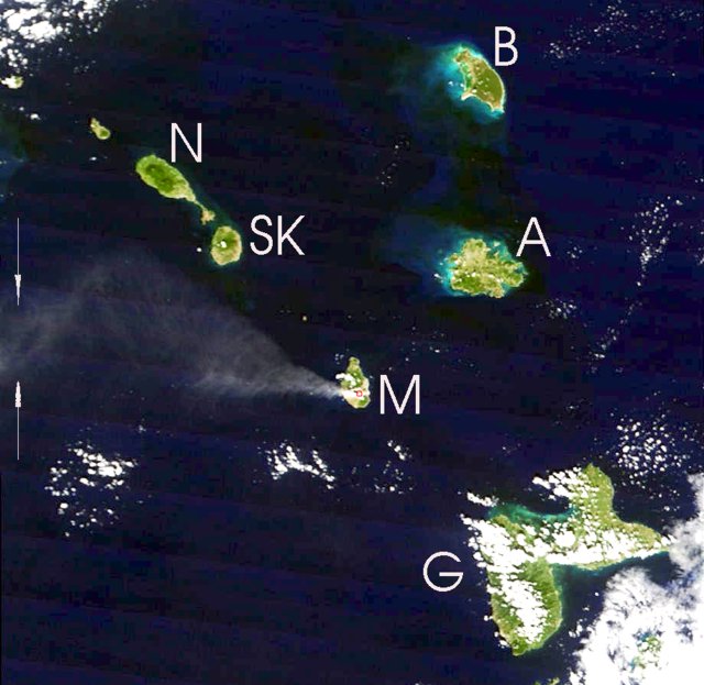 |
Figure 61. A MODIS image of an ash plume from Soufrière Hills acquired on 28 July 2005. N is towards the top. The plume was visible for over 100 km, but conspicuous portions of the plume continued beyond the W (left) side of this image between the arrows. A Washington VAAC report from that day suggested a plume to ~ 5 km altitude and 70-300 km long, blown W. Several islands neighboring Montserrat (M) are labeled: A, Antigua; B, Barbuda; G, Guadeloupe; N, Nevis; and SK, St. Kitts. For scale, the distance between the centers of the islands of Montserrat and Antigua is ~ 55 km. Some islands are ringed in bright blue-green, the possible result of coral reefs in shallow water, sediment, phytoplankton, or some combination of these conditions. Image and some elements of the caption courtesy of Jeff Schmaltz, MODIS Rapid Response Team, NASA. |
Geological Summary. The complex, dominantly andesitic Soufrière Hills volcano occupies the southern half of the island of Montserrat. The summit area consists primarily of a series of lava domes emplaced along an ESE-trending zone. The volcano is flanked by Pleistocene complexes to the north and south. English's Crater, a 1-km-wide crater breached widely to the east by edifice collapse, was formed about 2000 years ago as a result of the youngest of several collapse events producing submarine debris-avalanche deposits. Block-and-ash flow and surge deposits associated with dome growth predominate in flank deposits, including those from an eruption that likely preceded the 1632 CE settlement of the island, allowing cultivation on recently devegetated land to near the summit. Non-eruptive seismic swarms occurred at 30-year intervals in the 20th century, but no historical eruptions were recorded until 1995. Long-term small-to-moderate ash eruptions beginning in that year were later accompanied by lava-dome growth and pyroclastic flows that forced evacuation of the southern half of the island and ultimately destroyed the capital city of Plymouth, causing major social and economic disruption.
Information Contacts: Montserrat Volcano Observatory (MVO), Fleming, Montserrat, West Indies (URL: http://www.mvo.ms/).