Report on Erta Ale (Ethiopia) — July 2005
Bulletin of the Global Volcanism Network, vol. 30, no. 7 (July 2005)
Managing Editor: Edward Venzke.
Erta Ale (Ethiopia) Additional observations of the shrinking lava lake in January 2004
Please cite this report as:
Global Volcanism Program, 2005. Report on Erta Ale (Ethiopia) (Venzke, E., ed.). Bulletin of the Global Volcanism Network, 30:7. Smithsonian Institution. https://doi.org/10.5479/si.GVP.BGVN200507-221080
Erta Ale
Ethiopia
13.601°N, 40.666°E; summit elev. 585 m
All times are local (unless otherwise noted)
The most recent reported observations of Erta Ale made during 22-23 January 2005 (BGVN 30:01) described hornitos on a chilled lava lake surface. The following report is courtesy of Tony Waltham, who recently authored an article discussing the Afar Triangle (Waltham, 2005). These observations from January 2004 further illustrate the shrinking of the lava lake previously noted by a February 2004 expedition (BGVN 29:02).
A group of English geologists who visited on 15-16 January 2004 observed an active lava lake estimated at about 25 m across almost in the center of the lower lava floor within the S crater (figure 16) with a turbulent lava surface ~ 3 m below its rim. Crusting was minimal, and there was no development of substantial lava rafts. Modest fountaining occurred mainly over the zone of rising lava under the southern margin, and none was observed to rise more than 3 m to rim level. A hornito just a few meters high was active on the SE side (figure 17), a few meters from the lake, and night viewing revealed incandescence from a few other fissures across the old lava floor. Minimal fumarolic activity within the crater generated some periods of thin blue haze, though there were major emissions of sulphurous fumes from many fumaroles and fissures around the remains of the old northern crater.
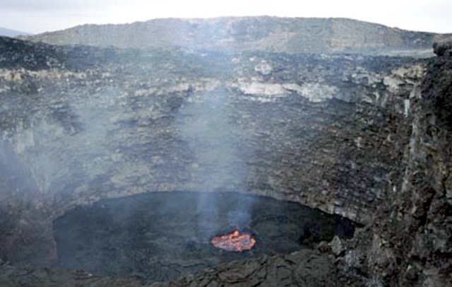 |
Figure 16. Erta Ale's remaining lava lake in the lower floor of the South crater, 15-16 January 2004. Courtesy of Tony Waltham. |
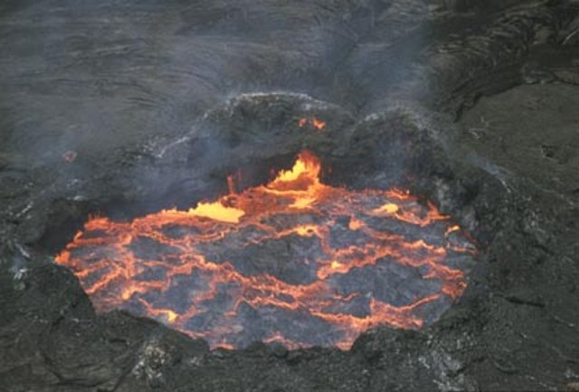 |
Figure 17. Telephoto view of Erta Ale's lava lake, with a hornito barely visible on the left side, 15-16 January 2004. Courtesy of Tony Waltham. |
Reference. Waltham, T., 2005, Extension tectonics in the Afar Triangle: Geology Today, v. 21, no. 3, p. 101-107.
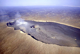
Geological Summary. The Erta Ale basaltic shield volcano in Ethiopia has a 50-km-wide edifice that rises more than 600 m from below sea level in the Danakil depression. The volcano includes a 0.7 x 1.6 km summit crater hosting steep-sided pit craters. Another larger 1.8 x 3.1 km wide depression elongated parallel to the trend of the Erta Ale range is located SE of the summit and is bounded by curvilinear fault scarps on the SE side. Basaltic lava flows from these fissures have poured into the caldera and locally overflowed its rim. The summit caldera usually also holds at least one long-term lava lake that has been active since at least 1967, and possibly since 1906. Recent fissure eruptions have occurred on the N flank.
Information Contacts: Tony Waltham, 11 Selby Road, Nottingham NG2 7BP, United Kingdom.