Report on Miyakejima (Japan) — July 2005
Bulletin of the Global Volcanism Network, vol. 30, no. 7 (July 2005)
Managing Editor: Edward Venzke.
Miyakejima (Japan) SO2 flux continues gradual decline; minor eruptions in November-December 2004
Please cite this report as:
Global Volcanism Program, 2005. Report on Miyakejima (Japan) (Venzke, E., ed.). Bulletin of the Global Volcanism Network, 30:7. Smithsonian Institution. https://doi.org/10.5479/si.GVP.BGVN200507-284040
Miyakejima
Japan
34.094°N, 139.526°E; summit elev. 775 m
All times are local (unless otherwise noted)
Seismicity and regular gas-and-steam plumes related to the eruption during the summer of 2000 continued through August 2003 (BGVN 28:10). From August 2003 through August 2005 gas emissions continued; SO2 flux remained relatively high and nearly constant (4,000-9,000 tons per day) since October 2002 (figure 21). Eruptions were absent in 2003. Seismicity increased again in May 2003 to more than 700 events/month (table 4), compared to less than 450 the previous four months, a level higher than any recorded since August 2000 (BGVN 28:10).
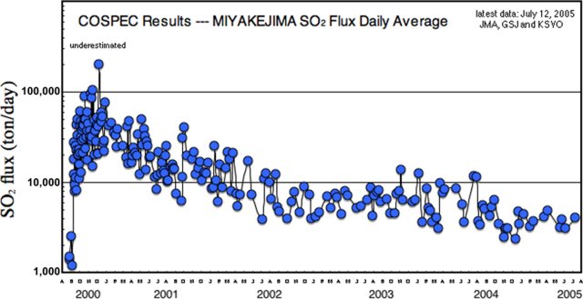 |
Figure 21. Daily average SO2 flux from Miyake-jima between August 2000 and July 2005. Courtesy of Kazahaya Kohei, Geological Survey of Japan. |
Table 4. Summary of seismicity and plume observations at Miyake-jima, May 2003-January 2005. All reported plumes originated from the summit crater, and were described as white (W) or gray (G). Data courtesy of JMA.
| Month | Volcanic earthquakes | Max. Plume Height (km) (date) | Plume Color (number of days, date) |
| May 2003 | 713 | 1.0 (3, 22) | W (22 days) |
| Jun 2003 | 811 | 0.9 (5) | W (17 days) |
| Jul 2003 | 762 | 0.8 (3) | W (13 days) |
| Aug 2003 | 562 | 1.0 (30) | W (7 days) |
| Sep 2003 | 551 | 0.9 (15) | W (17 days) |
| Oct 2003 | 649 | 1.0 (16, 27) | W (17 days) |
| Nov 2003 | 971 | 1.0 (14) | W (18 days) |
| Dec 2003 | 1,449 | 1.2 (4) | W (28 days) |
| Jan 2004 | 1,353 | 1.2 (28) | W (27 days) |
| Feb 2004 | 516 | 1.0 (16) | W (26 days) |
| Mar 2004 | 3,810 (590 on 7th) | 1.0 (3) | W (25 days) |
| Apr 2004 | 317 | 1.0 (16) | W (24 days) |
| May 2004 | 1,014 | 0.6 (21, 28) | W (13 days) |
| Jun 2004 | 1,134 (tremor amp. increased to 4 µm/s) | 0.8 (30) | W (13 days) |
| Jul 2004 | 1,025 | 1.0 (26) | W (16 days) |
| Aug 2004 | 643 | 1.2 (9) | W (11 days) |
| Sep 2004 | 468 | 1.0 (13) | W (14 days) |
| Oct 2004 | 776 | 1.0 (31) | W (21 days) |
| Nov 2004 | 1,015 | 1.0 (29) | W (25 days), G (1 day, 30th) |
| Dec 2004 | 1,634 | 1.5 (25) | W (28 days), G (1 day, 2nd) |
| Jan 2005 | 416 (tremor amp. drops below 1 µm/s) | 1.0 (14, 22) | W (28 days) |
The number of monthly events remained above 500 through February 2004, with counts of 1,449 in December 2003 and 1,353 in January 2004. Seismicity increased significantly during 5-15 March 2004, with more than 400 daily events recorded during 6-10 March (a high of 590 events on the 7th), before gradually declining, but resulting in a monthly total of 3,810. No unusual activity or eruptions accompanied the elevated seismicity. Although seismicity dropped in April 2004, more than 1,000 monthly seismic events were recorded during May-July 2004.
Seismicity was high again in November (1,015 events) and December (1,634 events) 2004, but the December seismicity was primarily due to over 700 events during 2-3 December. The amplitude of the continuous tremor also increased from below 1 ?m/s to around 4 ?m/s in June 2004. Amplitudes remained elevated, though variable, through December 2004.
On 30 November 2004 a minor ash eruption occurred after a 2-year lull. A minor eruption is defined as a small explosion with minor ash emission and plume height of less than 1 km. The Japanese Meteorological Agency (JMA) noted another gray plume on 2 December, and the Geological Survey of Japan (GSJ) listed minor eruptions on 2, 7-8, and 9 December 2004.
As of April 2005, the SO2 flux was about 2,000-5,000 tons/day. The danger of destructive eruptions was considered to be small, and some residents of the island (~ 3,800 people), who had been evacuated since September 2000 were returning home as of May 2005. However, the GSJ noted minor eruptions again on 12 April and 18 May 2005.
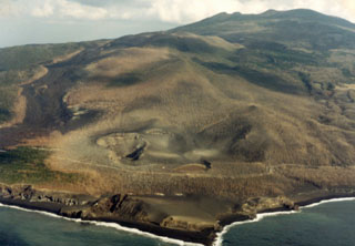
Geological Summary. The circular, 8-km-wide island of Miyakejima forms a low-angle stratovolcano that rises about 1,100 m from the sea floor in the northern Izu Islands about 200 km SSW of Tokyo. The basaltic volcano is truncated by small summit calderas, one of which, 3.5 km wide, was formed during a major eruption about 2,500 years ago. Numerous craters and vents, including maars near the coast and radially oriented fissure vents, are present on the flanks. Frequent eruptions have been recorded since 1085 CE at vents ranging from the summit to below sea level, causing much damage on this small populated island. After a three-century-long hiatus ending in 1469 CE, activity has been dominated by flank fissure eruptions sometimes accompanied by minor summit eruptions. A 1.6-km-wide summit crater was slowly formed by subsidence during an eruption in 2000.
Information Contacts: Japan Meteorological Agency (JMA), Volcanological Division, 1-3-4 Ote-machi, Chiyoda-ku, Tokyo 100, Japan (URL: http://www.jma.go.jp/); A. Tomiya, Geological Survey of Japan (AIST), 1-1 Higashi, 1-Chome Tsukuba, Ibaraki 305-856, Japan (URL: https://staff.aist.go.jp/a.tomiya/miyakeE.html); Kazahaya Kohei, Geological Survey of Japan (URL: https://staff.aist.go.jp/kazahaya-k/miyakegas/COSPEC.html); Earthquake Research Institute (ERI), University of Tokyo,Yayoi 1-1-1, Bunkyo-ku, Tokyo, 113-0032, Japan.