Report on Fuego (Guatemala) — August 2005

Bulletin of the Global Volcanism Network, vol. 30, no. 8 (August 2005)
Managing Editor: Richard Wunderman.
Fuego (Guatemala) Ongoing ash emissions, lava flows, and associated hazards into 2005
Please cite this report as:
Global Volcanism Program, 2005. Report on Fuego (Guatemala) (Wunderman, R., ed.). Bulletin of the Global Volcanism Network, 30:8. Smithsonian Institution. https://doi.org/10.5479/si.GVP.BGVN200508-342090
Fuego
Guatemala
14.4748°N, 90.8806°W; summit elev. 3799 m
All times are local (unless otherwise noted)
Fuego remained active into 2005, although this report focuses on the interval 31 December 2003 through 11 May 2004. A previous report discussed activity through the end of 2003 (BGVN 29:11); this report, based mainly on information from INSIVUMEH (Instituto Nacional de Sismologia, Vulcanologia, Meterologia y Hidrologia) covers the interval from end of 2003 to 11 May 2004.
Figure 7 is a map of the Fuego-Acatenango region, emphasizing drainages and settlements frequently mentioned in activity and hazard reports. Fuego is moderately close to the centers of some of Guatemala's largest cities, including the Capital (2-3.5 million inhabitants, ~ 40 km NNE of Fuego's summit) and Antigua (~ 32,000 inhabitants, ~ 18 km NNE).
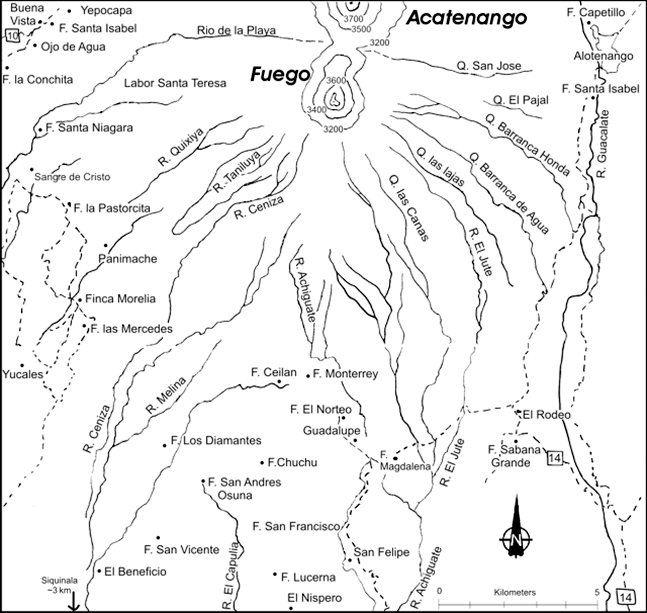 |
Figure 7. A sketch map of Fuego and adjacent Acatenango centered several kilometers S of these edifices. Numerous drainages emerge from the stratovolcano, their paths trending radially outward as well as in many cases curving decidedly S with distance from the volcano. Abbreviations 'R.' and 'Q.' apply to the Spanish-language terms Río (river) and Quebrada (canyon, and in this region these are often steep-sided, essentially gorges). 'F' stands for finca (farm or plantation, many of which grow the renowned Antigua coffee). A few contours are shown around these volcanoes (labeled in meters above sea level). The Fuego-Acatenango complex also contains two smaller (unlabeled) topographic highs, each one a few kilometers N of the better known peaks (i.e. N of Fuego, Meseta, and N of Acatenango, Yepocapa). Several towns off the map's margins are indicated with arrows and distances. Compiled by Bulletin editors from topographic maps. |
CONRED, the Guatemalan hazards agency (Cordinadora Nacional para la Reducción de Desastres) posted hazard information on their website, in part using a map format noting conditions seen from various perspectives. For example, the map issued for 9 January 2004 (during the largest crisis of the interval), included a title, a legend, a summary of critical hazards-oriented observations. One portion of the 9 January map reported a local wind velocity, N-NW at 12-18 km/hr, and the occurrence of fine and very fine ash falling within 5 to 15 km of the crater. The map also included key radio base stations and for each, a summary of the day's message content.
Many early 2005 observations were hampered by rainfall. Table 4 summarizes numerous INSIVUMEH daily reports during February, but for the bulk of the entries, it chiefly presents Smithsonian/USGS Weekly Reports to portray longer time spans.
Table 4. Samples of Fuego activity during 31 December 2003 through 11 May 2004. Summaries based largely on Smithsonian/USGS Weekly Reports are shown as multi-day intervals (marked with an asterisk, "*"). Most of the reported eruptions in column 3 were ash bearing. Courtesy of INSIVUMEH.
| Date | Maximum plume height (above summit) and bearing | Activity Description |
| 31 Dec-06 Jan 2004* | -- | During 1-5 January, lava emitted from Fuego flowed 70-100 m from the crater. Avalanches from the lava-flow fronts traveled W toward Santa Teresa ravine and toward Trinidad ravine. Seismic stations on the volcano recorded almost continuous harmonic tremor. |
| 07 Jan-13 Jan 2004* | ~3 km | Ash emission starting around 1500-1600 on 8 January (see text). |
| 21 Jan-27 Jan 2004* | ~1.5 km, SSW (22 Jan) | Smaller explosions to ~700 m above the crater. Incandescent avalanches traveled a maximum distance of 1 km toward Zanjon Barranca Seca, La Trinidad, and Rio Ceniza ravines. Not ashfall in populated areas. ~1.5 km from two strong explosions (evening of 22 January); blown SSW. During the rest of the week, smaller explosions sent plumes to ~700 m above the crater. |
| 28 Jan-03 Feb 2004* | ~1.1 km | Small-to-moderate explosions. The highest rising ash plume was produced from an explosion on 29 January. The plume reached above the crater and was accompanied by avalanches of volcanic material down Barranca Seca. A small amount of ash fell in Panimache village and possibly in Santa Sofia. On 31 January two small collapses in the S edge of the central crater produced small avalanches of lava blocks. |
| 16 Feb 2004 | 0.3-1 km, SW | Audible acoustic shock waves. Ashfall on upper edifice. |
| 17 Feb 2004 | -- | Incandescent avalanches rose 200 m at night, but some traveled into the drainages of the Taniluya, Ceniza, and Zanjon Barranca Seca. A mudflow descended the Quebrada Santa Teresa (on Fuego's W-SW sides) carrying blocks up to 2 m in diameter. During 0855 to 1140 Fuego produced 10 explosions characterized as strong, resulting in warnings to civil aviation authorities. Ashfall on W- and SW-flank communities. |
| 18 Feb 2004 | 1.5-1.7 km | A rapid succession of 15 early morning explosions at 10- to 30-second intervals were heard up to 8 km distant from the summit. Incandescent material landed on many of the upper slopes. Judging by the quantity and weight of ash fall, INSIVUMEH inferred that the eruption caused substantial changes in the summit area. Finer ash fell for 10 to 15 minutes on Finca Sangre de Cristo and environs. Besides aviation safety, concerns included drinking-water contamination. Ashfall up to 8 km from summit. |
| 20 Feb 2004 | 1.5-2 km; light to moderate S winds | Loud outbursts and incandescent avalanches down the W-flank valleys of the Seca, Taniluya, and Trinidad rivers, and to lesser extent down SE-flank valleys of the Las Lajas-El Jute rivers. Ash-bearing emissions came from the central crater at 4- to 9-minute intervals. Some traces of ash noted to the N, in the Capital. |
| 25 Feb-02 Mar 2004* | ~1.7 km | Weak-to-moderate explosions continued at Fuego, producing plumes above the crater. Avalanches of volcanic material traveled down several ravines, including Trinidad, Ceniza, Santa Teresa, and Taniluya (to the W). Explosions on 28 February deposited small amounts of fine ash in the village of Sangre de Cristo, and explosions on 29 February deposited ash W and SW of the volcano in the villages of Yepocapa and La Cruz. |
| 04 Mar-08 Mar* | ~1.5 km | On 5, 7, and 8 March avalanches of incandescent volcanic material traveled as far as 1.5 km down several ravines, including Seca, Taniluya, Ceniza, and Trinidad. Explosions on the 7th and 8th deposited ash 6-10 km from Fuego, including in the villages of Sangre de Cristo and Panimache. |
| 10 Mar-16 Mar 2004* | ~1.7 km | Explosions; incandescent avalanches as far as 600 m down ravines on the volcano's W, SW, and S flanks; ash fell in W- to SW-flank settlements from Sangre de Cristo to Panimache and Finca Morelia. |
| 17 Mar-23 Mar 2004* | ~1.3 km | Volcanic material traveled down the Seca ravine; ash fell in the village of Sangre de Cristo. |
| 24 Mar-30 Mar 2004* | ~1 km | Three strong explosions were recorded on 26 March; they caused incandescent avalanches in the Zanjon Barranca Seca and Trinidad ravines. On 29 March two explosions within 7 minutes produced ash plumes. A lahar occurred on 29 March in the Zanjon Barranca Seca ravine. |
| 31 Mar-06 Apr* 2004 | ~1.2 km (5 April, drifting SSE) | Lahars flowed down Seca Ravine on 30 March, and passed near the village of Sangre de Cristo on 3 April. Incandescent avalanches descended several ravines, including Santa Teresa, Ceniza, and Taniluya. |
| 07 Apr-13 Apr 2004* | ~1 km | Lava flowed 75-100 m from the central crater and avalanches of volcanic material traveled as far as 400 m towards Santa Teresa and Taniluya ravines. |
| 14 Apr-20 Apr 2004* | ~2.3 km (16 April, drifting S) | During 18-19 April, small eruptions hurled incandescent material up to 50 m above the vent. |
| 21 Apr-27 Apr 2004* | ~1 km (steam) | Weak explosions produced steam clouds above the volcano. In addition, small avalanches of volcanic material occasionally traveled W toward Santa Teresa Ravine. |
| 28 Apr-04 May 2004* | ~1.5 km | Ash-bearing explosions. On 28 April, an explosion produced an ash plume above the volcano, and ash was deposited ~4 km SW of the volcano in the villages of Panimache I and Panimache II. In addition, a small volcanic avalanche traveled W toward the Santa Teresa ravine. |
| 05 May-11 May 2004* | -- | Explosions chiefly produced gas-and-ash clouds. On 5 May a small lahar traveled to the W down Seca ravine. |
From the table, the pattern emerges of ongoing emissions with frequent plumes to 1 km and occasional higher plumes (several to ~2 km and one to ~3 km). Similar to previous months, the reports frequently mention dislodged lava blocks and mass wasting of volcanic materials.
The highest plume found in available reports of the interval occurred on 8 January 2004, when an ash plume rose ~3 km over the summit. Traces of ash fell in the Capital during this episode.
Fuego began its 8 January eruption around 1500 to 1600, expelling thick, broad columns of gases and ash to ~3 km above the crater. There were 25-30 explosions a minute accompanied by loud rumbling noises and acoustical shock waves felt 12 km away. Although no evacuations were ordered, settlements on the upper flanks were considered at risk, including San Andrés Iztapa, Chimaltenango, Comalapa, San Martín Jilotepeque, San José Poaquil, and Yepocapa.
The Washington VAAC added these observations: "[GOES 12] satellite imagery shows two plumes moving away from the volcano. The higher plume extends approximately 75 nm [~140 km] to the [N] and is estimated to be around FL250 [shorthand for 25,000 feet altitude, ~8 km]. A lower plume extends approximately 70 nm [126 km] to the [W] and is estimated to be up to FL190 (19,000 feet altitude, ~6 km). Hot spot activity has been fairly strong and constant over the past several hours."
A 20 February report described continued vigorous activity; ash emissions from the central crater rose to heights of 1.5-2 km above the summit (table 1). Light to moderate winds again blew the ash N and some traces fell in the Capital.
Geological Summary. Volcán Fuego, one of Central America's most active volcanoes, is also one of three large stratovolcanoes overlooking Guatemala's former capital, Antigua. The scarp of an older edifice, Meseta, lies between Fuego and Acatenango to the north. Construction of Meseta dates back to about 230,000 years and continued until the late Pleistocene or early Holocene. Collapse of Meseta may have produced the massive Escuintla debris-avalanche deposit, which extends about 50 km onto the Pacific coastal plain. Growth of the modern Fuego volcano followed, continuing the southward migration of volcanism that began at the mostly andesitic Acatenango. Eruptions at Fuego have become more mafic with time, and most historical activity has produced basaltic rocks. Frequent vigorous eruptions have been recorded since the onset of the Spanish era in 1524, and have produced major ashfalls, along with occasional pyroclastic flows and lava flows.
Information Contacts: Instituto Nacional de Sismologia, Vulcanología, Meteorología e Hidrologia (INSIVUMEH), Ministero de Communicaciones, Transporto, Obras Públicas y Vivienda, 7a. Av. 14-57, zona 13, Guatemala City 01013, Guatemala (URL: http://www.insivumeh.gob.gt/); Coordinadora Nacional para la Reducción de Desastres (CONRED), Av. Hincapié 21-72, Zona 13, Guatemala City, Guatemala; Washington Volcanic Ash Advisory Center (VAAC), Satellite Analysis Branch (NOAA/NESDIS), 4700 Silver Hill Road, Stop 9910, Washington, DC 20233-9910, USA (URL: http://www.ssd.noaa.gov/).