Report on Santa Maria (Guatemala) — October 2005

Bulletin of the Global Volcanism Network, vol. 30, no. 10 (October 2005)
Managing Editor: Richard Wunderman.
Santa Maria (Guatemala) Partial dome collapses in 2004; explosions and ash columns in 2005
Please cite this report as:
Global Volcanism Program, 2005. Report on Santa Maria (Guatemala) (Wunderman, R., ed.). Bulletin of the Global Volcanism Network, 30:10. Smithsonian Institution. https://doi.org/10.5479/si.GVP.BGVN200510-342030
Santa Maria
Guatemala
14.757°N, 91.552°W; summit elev. 3745 m
All times are local (unless otherwise noted)
Prior to the period covered by this report, recent activity at Santa María was characterized by weak-to-moderate explosions producing ash, crater-rim collapses and avalanches of block lava and ash, pyroclastic flows, and an active lava flow (BGVN 28:10). Activity was similar from October 2003 to June 2004, consisting mostly of explosions from Santiaguito, a lava-dome complex that includes the Caliente vent. The explosions produced ash plumes, and there were numerous block-lava-and-ash avalanches from Caliente collapses (BGVN 29:06). From July 2004 until October 2005, these types of activity continued.
Activity during July-September 2004. During July to September 2004, weak-to-moderate explosions at Santiaguito produced plumes to a maximum height of ~ 1.5 km above the volcano. Frequent avalanches of volcanic material including blocks and ash traveled SE and SW down Caliente cone. In early September 2004, several weak-to-moderate explosions produced ash clouds to a maximum height of 2 km above the volcano. Partial collapses of the lava dome caused pyroclastic flows to travel down the volcano's NE and SW flanks. On 27 September, several avalanches of volcanic material from active lava-flow fronts traveled SW.
Activity during October 2004. During October 2004 moderate explosions produced ash-and-gas plumes that rose to a maximum altitude of 9 km. Explosions on 4 October produced small pyroclastic flows to the SW. On 11 October, a partial lava-dome collapse to the SW produced a pyroclastic flow that traveled toward the Nimá Segundo River. An ash cloud formed that rose to a height of ~ 500 m and covered most of the dome complex. The collapse was preceded by an explosion that produced an ash-and-gas cloud to ~ 1.5 km above the volcano. Small explosions on 12 October produced small lava-dome collapses to the SW that generated avalanches of lava blocks and ash.
Small lahars traveled down San Isidro ravine on 14 and 15 October. A small collapse of the SW edge of the lava dome in the Caliente crater produced a pyroclastic flow on 17 October. The flow traveled down the S flank and produced a steam-and-ash plume to a height of ~ 800 m upon contact with dammed water. Instituto Nacional de Sismologia, Vulcanologia, Meteorologia, e Hidrologia (INSIVUMEH) reported that this collapse, like those that occurred on previous days and weeks, was associated with a new cycle of magmatic injection. The Washington VAAC reported that hot spots and plumes possibly containing ash were occasionally visible on satellite imagery on 21 October; imagery on 31 October showed a possible ash-bearing plume at ~ 4.5 km altitude.
Activity during November 2004. During November, weak-to-moderate explosions produced gas-and-ash plumes to ~ 1 km above the volcano. Many explosions were accompanied by block-and-ash avalanches from the NE and SW edges of Caliente dome. The Washington VAAC reported that satellite imagery on 3 November showed a possible ash-bearing plume at a height of ~ 5 km altitude. On 12 November, the collapse of a small sector of the SW edge of the Caliente dome produced a pyroclastic flow. On 14 November at 2012, a tectonic earthquake caused a lava-flow collapse SW of the Caliente dome, triggering a pyroclastic flow that descended to the head of San Isidro ravine, an area of abundant accumulation of pyroclastic material and a known area for lahar initiation. During December, weak-to-moderate explosions produced plumes to a maximum height of 1.3 km above the crater. Frequent block-lava avalanches traveled down the SW flank of Caliente dome. A moderate explosion on 4 December caused a partial lava-dome collapse and a pyroclastic flow that traveled SW. On 22 December small collapses occurred from lava-flow fronts on the SW side of Caliente dome. According to the Washington VAAC, ash plumes were visible on satellite imagery on several days during 22-27 December.
Activity during January-October 2005.During January 2005, frequent explosions (table 2) produced columns of gray and white ash up to 2 km in height, ash fall in towns near the volcano and frequent blocky avalanches. Early in the month, avalanches of incandescent blocks were released from lava flow fronts towards the NE and SE flanks of Santiaguito.
Table 2. Explosions recorded at the Santiaguito cone of Santa María in January 2005. Missing dates were not reported. Courtesy of INSIVUMEH.
| Date | Number of Explosions |
| 04 Jan 2005 | 93 |
| 07 Jan 2005 | 62 |
| 10 Jan 2005 | 31 |
| 11 Jan 2005 | 20 |
| 12 Jan 2005 | 14 |
| 13 Jan 2005 | 13 |
| 14 Jan 2005 | 15 |
| 24 Jan 2005 | 16 |
| 25 Jan 2005 | 56 |
| 26 Jan 2005 | 16 |
| 27 Jan 2005 | 52 |
| 28 Jan 2005 | 65 |
During February 2005, frequent explosions and avalanches continued. On 10 February 2005 the Washington VAAC reported that satellite imagery showed a plume of ash and steam moving SW from the summit and ash extending 55 km after an eruption around 0645. A continuous plume of ash and steam was emitted after an eruption around 0745 and ash extended around 230 km from the summit moving at 2-50 km/hour.
During March 2005, several weak-to-moderate explosions produced ash plumes to a maximum height of ~ 1.3 km above the dome. Avalanches of volcanic blocks traveled down the E and SW flanks of Caliente dome. On 16 March, small amounts of fine ash fell in Xepax, Xecavioc, Llanos de Pinal, Las Majadas, and Quetzaltenango. During 19-20 March, ash fell to the E in the town of Zunil.
During 21-25 April several explosions at Santiaguito produced ash plumes that rose to ~ 1.2 km above the dome. Lava avalanches occurred down the SW flank of Caliente dome. Explosions on 25 April produced pyroclastic flows that traveled S down Caliente.
Continuing explosive activity from Santiaguito during 4-9 May sent ash columns as high as 1.3 km above the vent. Small collapses at the Caliente dome generated pyroclastic flows 500-3,000 m long. Constant avalanches were reported on 10 May from the lava-flow front and the Caliente dome, along with one small ash explosion. Minor explosions on 13 May sent gray ash plumes 400-600 m high. Avalanches from the SW-flank lava flow continued. Explosions during 17-20 May produced ash clouds to ~ 1 km above the volcano; ash fell 7-10 km from Caliente dome.
During the first week of June 2005, moderate explosions produced plumes that rose to ~ 1.2 km above the volcano. On 2 June, the partial collapse of the lava dome in the crater of Caliente dome generated a pyroclastic flow that traveled ~ 4 km SW. On 22-24 June explosion columns reached ~ 900 m above the crater and extended several kilometers to the SSW and W. On 27 June, in the region of Palajunoj on the SW flank, constant avalanches of lava blocks were observed. During 6-18 July, weak-to-moderate explosions continued , with plumes rising to ~ 1.3 km above the volcano. Throughout July avalanches of volcanic material were produced at the front of an active lava flow, and from the SW edge of Caliente dome.
August and early September reports were unavailable, but during 7-11 September, small-to-moderate explosions at Santiaguito produced plumes that rose to a maximum height of ~ 1.5 km above the volcano on 8 September. On 7 September, a moderate lahar traveled down the volcano's flank. About a dozen pyroclastic flows, and avalanches of volcanic material occurred from the SW edge of the lava dome, and from the front of lava deposits on the SW flank of Caliente dome.
On 26 October 2005 a small eruption produced an ash plume that drifted SW to the Pacific and was recorded on MODIS satellite imagery (figure 33). The Washington VAAC reported a hot spot that lasted for about 6 hours with an estimated plume height of 4.5 km. On 28 October a plume rose to an altitude of ~ 4.9 km.
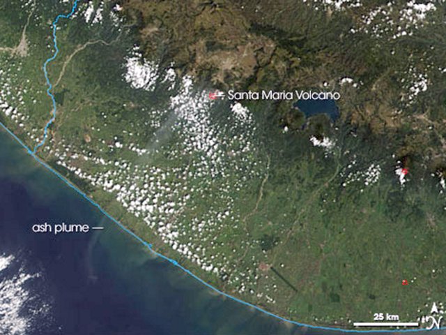 |
Figure 33. MODIS (Moderate Resolution Imaging Spectroradiometer) image showing a Santa María eruption plume on 26 October 2005. The volcano's summit is identifiable by a small red outline indicating an area hotter than its surroundings. Wafting away from the summit is a thin, faint ash plume that heads SW toward the Pacific. NASA image courtesy the MODIS Rapid Response Team at NASA GSFC. |
Geological Summary. Symmetrical, forest-covered Santa María volcano is part of a chain of large stratovolcanoes that rise above the Pacific coastal plain of Guatemala. The sharp-topped, conical profile is cut on the SW flank by a 1.5-km-wide crater. The oval-shaped crater extends from just below the summit to the lower flank, and was formed during a catastrophic eruption in 1902. The renowned Plinian eruption of 1902 that devastated much of SW Guatemala followed a long repose period after construction of the large basaltic andesite stratovolcano. The massive dacitic Santiaguito lava-dome complex has been growing at the base of the 1902 crater since 1922. Compound dome growth at Santiaguito has occurred episodically from four vents, with activity progressing E towards the most recent, Caliente. Dome growth has been accompanied by almost continuous minor explosions, with periodic lava extrusion, larger explosions, pyroclastic flows, and lahars.
Information Contacts: Instituto Nacional de Sismologia, Vulcanologia, Meteorologia e Hidrologia (INSIVUMEH), Unit of Volcanology, Geologic Department of Investigation and Services, 7a Av. 14-57, Zona 13, Guatemala City, Guatemala (URL: http://www.insivumeh.gob.gt/); Washington Volcanic Ash Advisory Center (VAAC), Satellite Analysis Branch (SAB), NOAA/NESDIS E/SP23, NOAA Science Center Room 401, 5200 Auth Road, Camp Springs, MD 20746, USA (URL: http://www.ospo.noaa.gov/Products/atmosphere/vaac/); NASA Earth Observatory (URL: http://earthobservatory.nasa.gov/).