Report on Ambae (Vanuatu) — November 2005

Bulletin of the Global Volcanism Network, vol. 30, no. 11 (November 2005)
Managing Editor: Richard Wunderman.
Ambae (Vanuatu) New eruption begins on 27 November 2005 and builds cone in crater lake
Please cite this report as:
Global Volcanism Program, 2005. Report on Ambae (Vanuatu) (Wunderman, R., ed.). Bulletin of the Global Volcanism Network, 30:11. Smithsonian Institution. https://doi.org/10.5479/si.GVP.BGVN200511-257030
Ambae
Vanuatu
15.389°S, 167.835°E; summit elev. 1496 m
All times are local (unless otherwise noted)
A new eruption began on 27 November 2005 when vapor plumes and ash columns were observed originating from Lake Voui, a crater lake at the summit of Aoba (figure 13). The volcano is also referred to locally as Manaro or Lombenben. Prior to this activity, the most recent reported volcanism consisted of phreatic explosions from the lake during March 1995 (BGVN 20:01, 20:02, and 20:08). Bathymetry conducted by ORSTOM in 1996 showed that the vent feeding gases and magma into Lake Voui had a depth of about 150 m and a diameter of about 50 m. The volume of water in the lake (1 x 2 km) totals some 40 million cubic meters, with a mean pH of 1.8. Lake Voui and the Manaro Ngoro summit explosion craters and cones formed ~ 420 years ago (figure 14). Lake Manaro was formed by the accumulation of water in a low-lying area of the Manaro summit caldera.
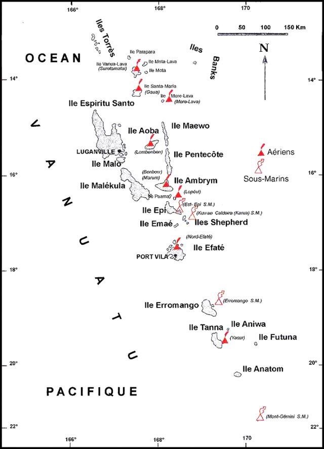 |
Figure 13. Map showing the location of volcanoes, including Aoba, in Vanuatu. Open triangles indicate submarine volcanoes. Modified from a map by IRD. |
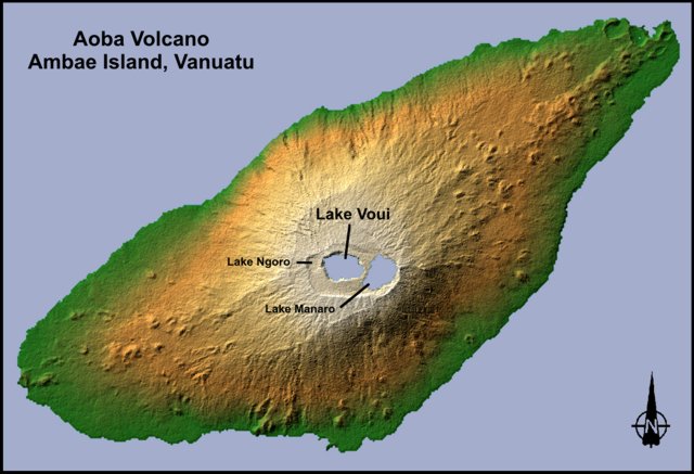 |
Figure 14. Digital image of Aoba created by combing shading and color coding of topographic height. The shading indicates direction of the slopes; NW slopes appear bright, while SE slopes appear dark. Color coding shows height, with green at the lower elevations, rising through yellow and tan, to white at the highest elevations. The flattened-looking summit shows that the newest crater is actually nested within older, larger craters. Elevation data used in this image were acquired by the Shuttle Radar Topography Mission (SRTM) aboard the Space Shuttle Endeavour, launched on 11 February 2000. Annotations added by Smithsonian editors. Courtesy of NASA. |
Starting on 3 December a team of volcanologists from the Vanuatu Department of Geology, Mines, and Water Resources (DGMWR), the French Institut de recherche pour le développement (IRD), the New Zealand Institute of Geological & Nuclear Sciences (GNS), and New Zealand's Massey University began collaborating on observations and monitoring. The amplitude of tremor recorded by DGMWR instruments from 30 November to 3 December was lower than during the March 1995 activity.
Scientists who visited the lake on 4 and 5 December (figures 15 and 16) observed a similar style of eruptive activity on both days, but some individual explosions appeared larger on the 5th. It was not possible to reach the lake to collect a water sample. There appeared to be two active vents, side by side, in the lake. One was producing eruptions of mud, rocks, and water, and the other appeared to be the source of the large continuous steam plume rising above the crater; the plume did not contain ash. There were no reports of ash falling on the island since the start of the eruptions the previous week. The team estimated that the cone being built in the lake, at an estimated height of more than 20 m on the 4th, was about 70% complete around the active vents, and grew 5-10% higher between 4 and 5 December. Continuous tremor was recorded during this time, and the level of eruptive and seismic activity seemed to be fairly stable.
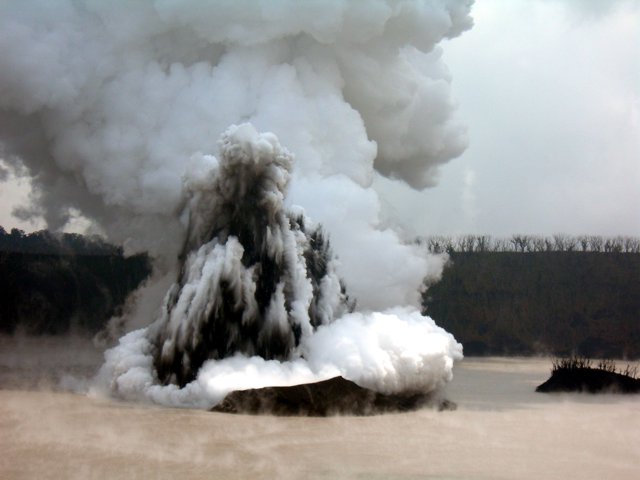 |
Figure 15. Photograph showing a telephoto view of an explosive eruption from Lake Voui at Aoba, 4 December 2005. View is approximately towards the east from the crater rim. Courtesy of Philipson Bani, IRD. |
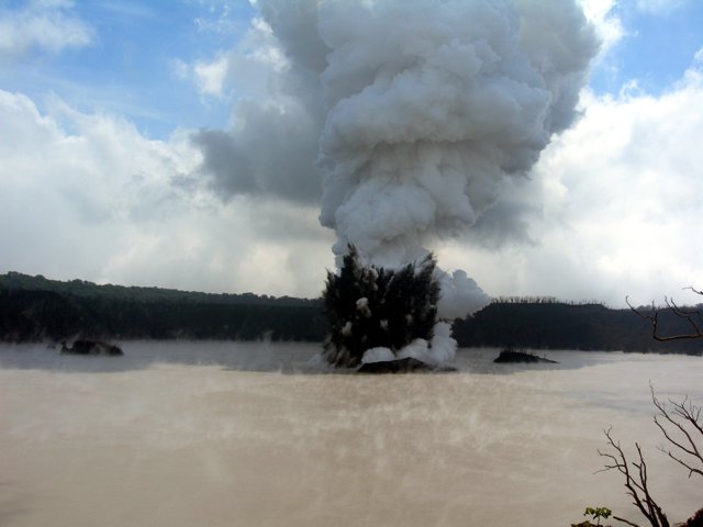 |
Figure 16. Photograph showing an explosive eruption from Lake Voui at Aoba on 4 December 2005. View is approximately toward the E from the crater rim. A large steam plume can be seen rising above the darker zone containing pyroclastic material. Three small islands formed prior to this eruption can also be distinguished, with the active vent area closest to the western-most island. Courtesy of Philipson Bani, IRD. |
Cloud cover and rain prevented a visit to the lake on 6 and 7 December. Earthquake recorders from the GNS were installed at the Provincial Centre at Saratamata, the Longana Peoples Centre (Lovonda village), and at Tahamamavi ("place of warm sea") (figure 17). On 7 December, a final recorder from the IRD was installed near Nduidui on the SW side of the island. Over 6-7 December continuous moderate-level volcanic tremor was recorded, with no significant change in its level; there was no other significant seismic activity.
 |
Figure 17. Hazard map of Aoba, showing risk areas, infrastructure, and settlements. See Cronin and others (2004) for additional details. Map produced by the United Nations, OCHA-ROAP Information Management Unit, 2 December 2005. |
On 8 December, the group noted that small-scale eruptions continued in Lake Voui, building a volcanic cone in the lake and producing a tall (2.4-3.0 km) steam-and-gas plume. Afternoon observations showed the cone growing taller and surrounding three sides of the active vents. However, the cone was not complete on its E side, allowing lake water to react with the rising magma. Though the resulting explosions became further apart and slightly larger, the total energy involved appeared similar to 4-5 December. There continued to be two active vents, one producing the small explosions, and the second the steam and gas emissions. Seismic recorders continued to record volcanic tremor, but very few local earthquakes. No volcanic ash was present in the plume. The eruption had no immediate effect beyond Lake Voui. The Volcanic Alert Level remained at Level 2. The level of seismic activity seemed to be stable. No other significant seismic activity was recorded.
While departing by air on the evening of 8 December, the group clearly saw the active vents (figure 18). The cone had grown to the W, joining and partly burying one of the old islands. All eruptions occurred from inside the cone. The largest individual eruptions threw material 150-200 m above the lake. There was also a gas-and-steam vent present within the cone, W of the other vent. The level of the lake appeared unchanged.
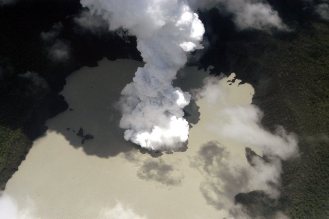 |
Figure 18. Aerial photograph showing a steam plume rising from Lake Voui at Aoba, 8 December 2005. Courtesy of Forces Armées en Nouvelle Calédonie (FANC). |
On 10 December, the small-scale volcanic eruption continued from active vents within the summit crater lake (Lake Voui). Molten material entered the crater lake and reacted with the water to produce small explosive eruptions and a plume of steam and gas. The eruption built a cone around the active vents, enclosing them on three sides, forming an island about 200 m across and 50-60 m high. There were two vents, one erupting water, rocks and mud, and the other producing a tall column of steam and gas. The eruption had little effect outside the crater lake (minor ashfall occurred only in the first three days of the eruption). Five days of seismic recordings show a moderate level of seismic activity (mostly volcanic tremor).No change was noted in the level of Lake Voui, and there was also no evidence of ground uplift or fractures near the lake.
Sulfur dioxide measurements. SO2 data collected using a DOAS spectrometer on the Islander planes of Unity Air Lines (3 December) and Air Vanuatu (5 December). On 3 December the flux was 32.6-33.6 kg/s (~ 2,900 metric tons/day). By 5 December the flux had decreased about 25%, to 24.7-26.4 kg/s (~ 2,300 metric tons/day). SO2 was clearly detected by the OMI (ozone monitoring instrument) sensor on the NASA Aura satellite (figure 19). One measurement of the volcanic gas output on 10 December showed a moderate level of sulfur dioxide (SO2) gas (about 2,000 t/d) from the active vents.
 |
Figure 19. SO2 data from the Ozone Monitoring Instrument (OMI) on the Aura satellite, 5 December 2005. Courtesy of NASA, the KNMI MOI Science Team, and Simon Carn, University of Maryland-Baltimore County. |
Lake temperatures. A monitoring station for continuous measurements of water temperature at Lake Voui was installed in October 1998. The station used a satellite ARGOS transmission system and recorded the last heating episode of 2001 (figure 20), but failed after three years due to the harsh acid environment. ASTER thermal infrared images can also be used for monitoring lake surface temperatures, and Aoba has a freshwater lake (Manaro Lakua) which can be used to remove the seasonal/diurnal variations in atmospheric temperatures. Unfortunately, the top of the volcano is frequently covered by clouds and few ASTER images are exploitable. The most recent ASTER image clearly showing both lakes was collected on 9 July 2005. Difference in temperatures between lake Voui and Lakua was 4.0°C, slightly above background values during 2002-2003. Maximum background temperatures measured with ASTER during the September 2002-October 2005 were at 26.3°C. The last ASTER images before the eruption, on 5 October 2005, showed no unusual temperatures at Lake Voui.
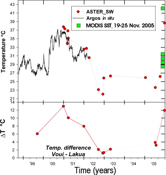 |
Figure 20. Temperature data from Lake Voui at Aoba, October 1998-December 2005, from in-situ measurements, ASTER satellite imagery, and MODIS satellite data. Delta T represents the thermal anomaly calculated as the temperature differences between the two lakes. The figure includes the first post-eruption ASTER data (24 December 2005). ARGOS data from Michel Halbwachs (Université de Savoie) and Michel Lardy (IRD). Courtesy of Alain Bernard. |
MODIS satellites have a more frequent coverage than ASTER but their spatial resolution is only 1 km. The surface area of Lake Voui (2.1 km2) is too small for an accurate measurement of lake temperature, but MODIS can detect rough temperature changes or an increased thermal anomaly. The MODIS pixel footprint is about 1 km along track and 2 km across track, so the measured temperatures are a mixed signal corresponding to the lake and some signal from the adjacent tropical forest (much colder than the lake at night at this elevation). MODIS SST imagery showed a strong thermal anomaly on 21 November 2005 (figure 20). Approximate lake temperatures, likely a minimum, were 30.4°C on 20 November and 29.5°C (Terra)/ 31.4°C (Aqua) on 21 November. On 25 November the temperature jumped to about 42°C.
Reference. Cronin, S.J., Gaylord, D.R., Charley, D., Alloway, B.V., Wallez, S., and Esau, J.W., 2004, Participatory methods of incorporating scientific with traditional knowledge for volcanic hazard management on Ambae Island, Vanuatu: Bulletin of Volcanology, v. 66, p. 652-668. (URL: http://www.proventionconsortium.org/files/tools_CRA/CS/Vanuatu.pdf)
Geological Summary. The island of Ambae, also known as Aoba, is a massive 2,500 km3 basaltic shield that is the most voluminous volcano of the New Hebrides archipelago. A pronounced NE-SW-trending rift zone with numerous scoria cones gives the 16 x 38 km island an elongated form. A broad pyroclastic cone containing three crater lakes (Manaro Ngoru, Voui, and Manaro Lakua) is located at the summit within the youngest of at least two nested calderas, the largest of which is 6 km in diameter. That large central edifice is also called Manaro Voui or Lombenben volcano. Post-caldera explosive eruptions formed the summit craters about 360 years ago. A tuff cone was constructed within Lake Voui (or Vui) about 60 years later. The latest known flank eruption, about 300 years ago, destroyed the population of the Nduindui area near the western coast.
Information Contacts: Esline Garaebiti, Douglas Charley, Morris Harrison, and Sandrine Wallez, Department of Geology, Mines, and Water Resources (DGMWR), Port-Vila, Vanuatu; Michel Lardy, Philipson Bani, Jean-Lambert Join, and Claude Robin, Institut de recherche pour le développement (IRD), BP A5, 98 848 Nouméa CEDEX, New Caledonia (URL: http://www.suds-en-ligne.ird.fr/fr/volcan/vanu_eng/aoba1.htm); Brad Scott and Steve Sherburn, Institute of Geological & Nuclear Sciences (GNS), Wairakei Research Center, Taupo, New Zealand; Shane Cronin, Institute of Natural Resources, Massey University, Palmerston, New Zealand; Alain Bernard, IAVCEI Commission on Volcanic Lakes, Université Libre de Bruxelles, Brussels, Belgium (URL: http://www.ulb.ac.be/sciences/cvl/aoba/Ambae1.html); NASA Earth Observatory (URL: http://earthobservatory.nasa.gov/); United Nations, Office for the Coordination of Humanitarian Affairs (OCHA), Regional Office for Asia and the Pacific.