Report on Nyiragongo (DR Congo) — January 2006

Bulletin of the Global Volcanism Network, vol. 31, no. 1 (January 2006)
Managing Editor: Richard Wunderman.
Nyiragongo (DR Congo) Continuous ash plumes and active lava lake
Please cite this report as:
Global Volcanism Program, 2006. Report on Nyiragongo (DR Congo) (Wunderman, R., ed.). Bulletin of the Global Volcanism Network, 31:1. Smithsonian Institution. https://doi.org/10.5479/si.GVP.BGVN200601-223030
Nyiragongo
DR Congo
1.52°S, 29.25°E; summit elev. 3470 m
All times are local (unless otherwise noted)
During May and June 2004, eruptions of Nyiragongo produced ash plumes that rose to a maximum of 6 km altitude (BGVN 29:06). According to the Toulouse VAAC, eruptions continued through July, producing plumes to a maximum of 5.5 km altitude. On 7 and 28 September 2004, short-lived plumes that may have contained ash were visible on satellite imagery. The Alert Level for the nearby city of Goma remained at Yellow.
An eruption on 3 November 2004 produced a thin W-drifting plume to 3.6-4.9 km altitude that was visible on satellite imagery. On 22 November a narrow SW-drifting plume was discerned on satellite imagery at 5 km altitude. A narrow plume was seen again on satellite imagery on 23 November at 1130, although no ash was identifiable.
The Goma Volcano Observatory (GVO) reported that during 10-17 November 2004 continuous volcanic tremor was recorded at all seismic stations around Nyiragongo. Visual observation on 12 and 13 November revealed that the lava lake surface had widened considerably, with strong lava fountains. Numerous Pele's hair and scoriae were seen on the cone's S, W, and N sides. A gas plume and incandescence were visible above the volcano. All fractures that opened during the 2002 eruption on the S flank had widened slightly and showed minor temperature increases.
During 18-29 November 2004, continuous banded tremor at high amplitudes occurred beneath the volcano, but the amplitudes seemed to be lower than during 9-18 November. Visual observations on 25-26 November revealed a slight decrease in the level of the lava lake, although strong lava fountains and a high flux of lava and gases continued. Pele's hair, scoriae, a gas plume, and incandescence were still present. Measurements of the fractures on the slopes showed that they remained stable.
The Toulouse VAAC reported faint SO2 plumes from Nyiragongo visible on satellite imagery on 8 and 10 December. During 29 November to 12 December, volcanic activity remained at relatively high levels. Nearly continuous high-amplitude tremor was recorded at all seismic stations on the volcano. Observations of the crater area on 9 and 10 December revealed that the level of the lava lake remained stable compared to previous visits and that strong lava fountaining was present. Pele's hair and scoriae fell in the area around the volcano, gas plumes rose above the volcano, and strong incandescence was visible at night.
In May 2005 a visiting group from Société de Volcanologie Genève (SVG) estimated that the lava lake was approximately 200 x 150 m across. They observed lava fountaining in the lake to tens of meters high (figure 33).
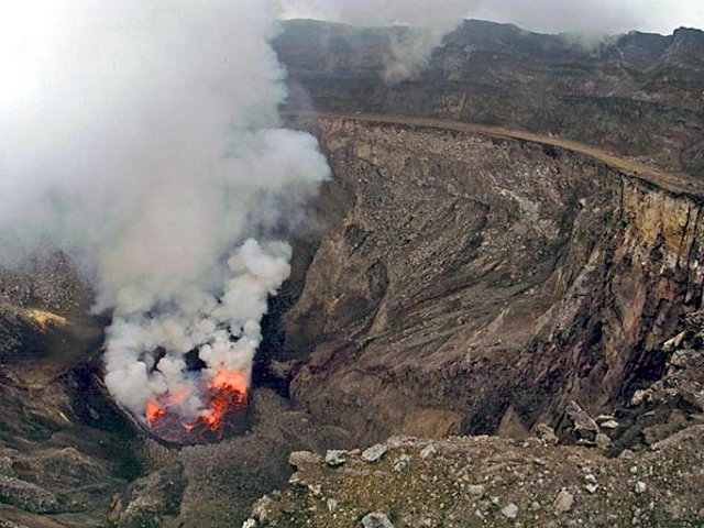 |
Figure 33. This photo presents Nyiragongo's lava lake in a view from a point on the second platform, which lies ~250 m below the summit. The inner pit with the new lava lake formed after the 2002 lateral eruption. The exact date when the photo was taken in January 2006 is unknown. Photo copyright Marc Caillet and provided courtesy of Pierre Vetsch, SVG. |
On 7 September 2005, high-resolution satellite imagery showed a thin plume emitted from Nyiragongo. The plume was not confirmed by other data. Another thin plume visible on satellite imagery on 10 October; it was not confirmed by SO2 data.
As of 28 October 2005 Nyiragongo remained very active, but stable, with a large active lava lake in the crater. A gas plume was emitted and incandescence was visible at night from several tens of kilometers away. On 7 and 13 November thin plumes from Nyiragongo that may have contained some ash were observed on satellite imagery.
In January 2006 a group from Stromboli Online undertook an expedition to Nyiragongo and photographed the lava lake (figure 34).
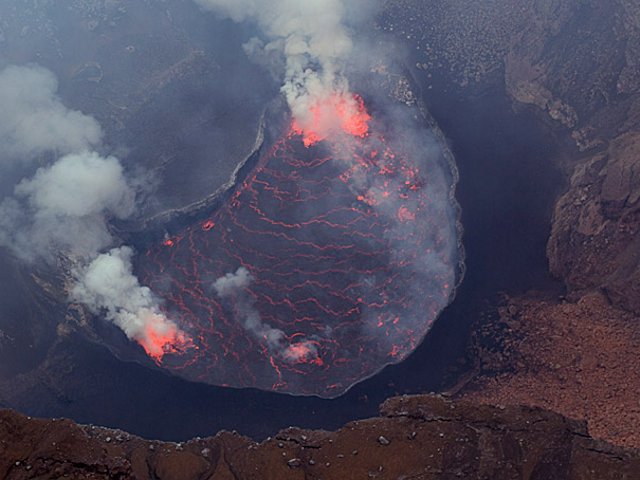 |
Figure 34. This photo of Nyiragongo's lava lake was taken from the Belvedere (Bastion) on the crater's W rim. The lake is ~ 300 m wide and its surface sat ~585 m below the rim. The second platform cuts across the bottom foreground. The exact date when the photo was taken in January 2006 is unknown. Photo courtesy of Marco Fulle. |
Geological Summary. The Nyiragongo stratovolcano contained a lava lake in its deep summit crater that was active for half a century before draining catastrophically through its outer flanks in 1977. The steep slopes contrast to the low profile of its neighboring shield volcano, Nyamuragira. Benches in the steep-walled, 1.2-km-wide summit crater mark levels of former lava lakes, which have been observed since the late-19th century. Two older stratovolcanoes, Baruta and Shaheru, are partially overlapped by Nyiragongo on the north and south. About 100 cones are located primarily along radial fissures south of Shaheru, east of the summit, and along a NE-SW zone extending as far as Lake Kivu. Many cones are buried by voluminous lava flows that extend long distances down the flanks, which is characterized by the eruption of foiditic rocks. The extremely fluid 1977 lava flows caused many fatalities, as did lava flows that inundated portions of the major city of Goma in January 2002.
Information Contacts: Baluku Bajope and Kasereka Mahinda, Observatoire Volcanologique de Goma, Departement de Geophysique, Centre de Recherche en Sciences Naturelles, Lwiro, D.S. Bukavu, DR Congo; J?rg Alean, Roberto Carniel, and Marco Fulle, Stromboli Online, Rheinstrasse 6, CH-8193 Eglisau, Switzerland (URL: http://www.swisseduc.ch/stromboli/); Pierre Vetsch and Marc Caillet, Société de Volcanologie Genève (SVG), PO Box 6423, CH-1211 Geneva 6, Switzerland (URL: http://www.volcan.ch/); Toulouse Volcanic Ash Advisory Center (VAAC), Météo-France, 42 Avenue Gaspard Coriolis, F-31057 Toulouse cedex, France (URL: http://www.meteo.fr/vaac/).