Report on Augustine (United States) — January 2006
Bulletin of the Global Volcanism Network, vol. 31, no. 1 (January 2006)
Managing Editor: Richard Wunderman.
Augustine (United States) January 2006 eruptions; pyroclastic flows, ash plumes, and aviation hazards
Please cite this report as:
Global Volcanism Program, 2006. Report on Augustine (United States) (Wunderman, R., ed.). Bulletin of the Global Volcanism Network, 31:1. Smithsonian Institution. https://doi.org/10.5479/si.GVP.BGVN200601-313010
Augustine
United States
59.3626°N, 153.435°W; summit elev. 1218 m
All times are local (unless otherwise noted)
Following a period of increased seismicity at Augustine that began in May 2005, discrete seismic events on 9 and 11 December may have perturbed the hydrothermal system, initiating small steam explosions. On 12 December, a plume extended 75 km SE of the volcano, and its S and E flanks were dusted with ash (likely non-juvenile). Additional steam explosions took place later in the month, and the smell of sulfur was reported by residents in villages on the E side of Cook Inlet. The first major eruptions at Augustine occurred on 11 January 2006, when two discrete explosions produced an ash cloud that reached 9 km altitude (BGVN 30:12) and the Concern Color Code was raised to Red. Further eruptions occurred on 13, 14, and 17 January. After the eruption at 0758 on 17 January, seismicity diminished significantly and AVO lowered the color code from Red to Orange late on 18 January.
By the morning of 19 January seismicity remained fixed at lower levels; it decreased further on 20 January but was still above background. Periods of quiescence and low seismicity in the intervals between eruptive events are not unusual at Augustine, having occurred during the 1976 and 1986 eruptive episodes. During 23-26 January, satellite observations indicated the persistence of faint thermal anomalies and steaming continued at the summit.
Occasional intervals of increased seismicity were observed for the next few days. On 27 January 2006 an explosive eruption began at about 2000 and lasted for 9 minutes. AVO raised the color code from Orange to Red. According to the National Weather Service (NWS), an ash cloud reached a maximum altitude of around 9 km and drifted SE. Augustine erupted again at 2337 on 27 January 2006. This event lasted 1 minute and no ash was detected above 3 km. A third eruption occurred at 0204 on 28 January 2006 and lasted 2 minutes. Ash drifted SE at an altitude of about 8 km according to NWS. A fourth eruption occurred at 0742 on 28 January and lasted 3 minutes; the ash cloud drifted SE at a maximum altitude of 7.5 km.
Another explosive event began at 1430 on 28 January. Seismic activity continued and continuous ash emission was observed in AVO web camera images. NWS reported ash to 9 km altitude travelling SSW. Following this explosion, Augustine was in a state of continuous eruption accompanied by persistent ash emission until around 3 February.
Overflight observations on 29 January suggested that pyroclastic flows were being produced. NWS radar indicated that ash clouds from events at 1117 on 29 January, and 0325 and 0621 on 30 January, rose to 7.5 km altitude. Other than during these three events an ash-rich plume rose to about 4 km altitude. On 30 January, Alaska Airlines canceled all flights into and out of Anchorage because of the potential danger of ash. Flights resumed on 31 January.
On 1 February AVO lowered the Concern Color Code from Red to Orange. Although seismic data indicated sustained eruptive activity, ash clouds to altitudes greater than 4.5 km altitude had not been observed on NWS radar since 0621 on 30 January. Low-level explosions, pyroclastic flows, and production of ash continued (figure 26).
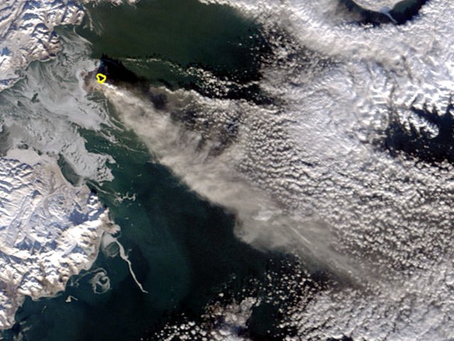 |
Figure 26. A satellite image showing the Augustine eruption on 2 February 2006. On that day the Alaska Volcano Observatory reported a continuous ash plume accompanied by low-level explosions and pyroclastic flows of hot ash and rock fragments. This image was taken by the Moderate Resolution Imaging Spectroradiometer (MODIS) onboard the Terra satellite. Augustine is partially outlined in this image, indicating a ground surface much hotter than its surroundings; the volcano's ash plume is pale gray-beige, barely darker than the nearby weather clouds. However, the weather clouds can be discerned from the ash by their distinct dot-like pattern. NASA image courtesy Jeff Schmaltz, MODIS Rapid Response Team at NASA GSFC. |
By 3 February seismic data indicated that low-level explosions, block-and-ash-flows, and sustained production of ash were continuing intermittently and had changed little in character or intensity since 1 February. Seismicity dropped significantly on the evening of 3 February. Observers on an overflight on 3 February saw a steam-rich, ash-poor plume emerge from the cloud tops and reach no higher than 2 km altitude. NWS reported no ash in satellite or radar data.
Observations by AVO scientists during visits on 8 February, as well as satellite and seismic data and other remote observations, indicated that a lava dome was present at the summit. Streams of gas, ash, and incandescent blocks were observed descending the upper NE flank on the evening of 7 February and early on the 8th, indicating that small-volume collapses of the lava dome were occurring and that the dome was actively growing. Seismicity remained at low levels, though still above background. Low-level ash plumes and occasional pyroclastic flows on the flanks continued. A persistent thermal signal was observed in satellite data. Incandescence was visible from Homer.
On 11 February, seismic data indicated that the new lava dome at Augustine's summit continued to grow. Seismic stations on the flanks of the volcano recorded rockfalls and pyroclastic flows associated with small-volume collapses of the lava dome. A plume composed of gas, steam, and small amounts of ash continued to be emitted from the summit, and low-level, dilute ash clouds were likely present in the vicinity of the volcano.
Just before midnight on 12-13 February a low-light camera operated by the University of Alaska Fairbanks captured a small hot avalanche down the north flank of the volcano. The event was also recorded on AVO's pressure sensor on Augustine Island. A light dusting of new ash on the E flank of the volcano may have been related to this avalanche event. Satellite data on 13 February showed a persistent thermal anomaly at the volcano's summit. Together, these data suggested that the lava dome continued to grow and underwent occasional, minor collapse events.
On 16 February, clear satellite views showed a strong thermal anomaly in the summit crater area. Seismometers continued to record rockfalls and small pyroclastic-flow signals indicative of occasional, minor collapses of the lava dome. Over 10-16 February, the number of these events declined steadily, suggesting that the rate of lava effusion was slowing. An observation flight on 16 February obtained good views of the summit: a new, steaming, blocky lava dome occupied the summit crater. The dome filled much of the crater and extended as a rubbly tongue 500-800 m down the upper N flank. Dark aprons of collapse debris, including large steaming blocks, extend downslope to the N. The rim of the summit crater was largely snow-free and mantled by thick, coarse, pyroclastic deposits, likely from the explosive events in January. The dome resulted from the largely non-explosive extrusion of degassed lava following the cessation of explosive activity on January 30.
By the end of this report period (22 February) unrest was continuing. Seismicity remained above background levels. Rockfalls and avalanches from the lava dome continued but appeared to be declining in frequency. Satellite images continued to show a persistent thermal anomaly. A plume composed of variable amounts of gas, steam, and small amounts of ash likely continued intermittently from Augustine's summit. Dome building eruptive activity may continue intermittently over the next several months.
Aviation hazard. Tina Neal (USGS-AVO) provided some thought-provoking insights into Augustine's aviation-ash issues. The following quote with minor modification is information she sent in a 14 February email message to the Volcanicclouds listserve, some follow up messages, and a review.
"Volcanologists often rely upon pilot observations to provide the all-important visual confirmation and description of distant volcanic events. What we need to remember, however, is that it is quite difficult to get more than snippets of information in a PIREP [aviation pilot report]: Pilots and controllers are often extremely busy and controllers cannot ask more than very basic follow up questions. Air traffic communication protocols put a premium on succinct transmissions. I was lucky enough recently to hear this play out in real time during an Augustine eruption when I happened to be visiting the Anchorage Air Traffic Control facility and was allowed to plug in to monitor the sector around Augustine. While we should continue to encourage full and detailed PIREPs following the VAR [Volcanic Activity Report] format, we should not be terribly surprised when the return is not very complete. Similarly, follow up communications directly with the pilot, possible in some cases, are difficult and not the highest priority of Observatory staff.
"Thus far for the Augustine eruption, we do have documentation of impacts from the ash clouds and the distal fine ash and SO2 cloud from explosive events, largely taken from PIREPS passed to AVO by the FAA and the National Weather Service. In addition to these instances below, flight routes were moved in anticipation of possible ash cloud motion following several explosions, and flight cancellations did occur.
"[1.] On 14 January a jet aircraft about [80 km E] of Yakutat at FL310 [9.4 km altitude, at 59 deg. 30.65 min. N, 139 deg. 8.89 min. W; ~800 km from Augustine] skimmed through the top of the 'brown' cloud for about 10 minutes and reported smelling a 'dirty, musty odor.' The pilot climbed to FL330 and deviated to the NE around the cloud. [The plane was out of service for two days.] Borescope inspection upon landing showed no damage and no ash accumulation.[Later anaysis suggested the ash cloud encountered may have been a combination of 5 separate drifting ash clouds from 5 separate discrete events during 13-14 January.] "[2.] On the same day, another jet near the same location saw a brown haze layer about 2000 feet [610 m] thick and made a climbing turn to avoid it.
"[3. On] 31 January [there were reports of a] light sulfur smell from several aircraft over Anchorage.
"[4.] AVO received the followings email account about a possible encounter between a Cessna Cherokee and a distant ash cloud from Augustine on 30 January (we have yet to follow up for any further information and verification).
"I am traveling in the Bristol Bay Area and was in Togiak last night. Last night I started coughing and sneezing and on the flight to Dillingham this morning the pilot and I noticed volcanic ash in the air from ground level and according to the pilot up to 7,000 feet [2.1 km altitude]. The ash is very fine but is sticking to the wind screen of the aircraft. Along with the ash my eyes were stinging and I noticed a little burning in my nose. As we approached the Dillingham area and got out of the mountains the air quickly cleared. At this time it seems to only be in the mountains and according to the pilots in different places all the way to King Salmon. I do not know if you have received these reports yet."
In addition, Volcaniclouds discussions included this message from Ken Dean (Geophysical Institute-AVO). It provided some further discussion and references on past eruption-cloud behavior from Mt. Cleveland (1,250 km SW of Augustine).
". . . there was an incident on 22 February 2001 attributed to a volcanic cloud from the eruption of Cleveland Volcano on 19 Feb. 2001. A PIREP from a B747 near San Francisco [California] reported a strong (sulfur) smell and particles in the cabin. At first we thought this was an erroneous report since it was so far from the eruption and satellite date did not show anything in the region of the aircraft. However, when we ran the Puff dispersion model using re-analysis data, the simulated volcanic cloud encountered the aircraft at the time of the PIREP. This was a match in space, time and altitude. Note: Puff runs using predicted data were somewhat ambiguous regarding this encounter but the re-analysis data were much more definitive."
References. Dean, K.G., Dehn, J., Papp, K.R., Smith, S., Izbekov, P., Peterson, R., Kearney, C., and Steffke, A., 2004, Integrated satellite observations of the 2001 eruption of Mt. Cleveland: Alaska, J. Vol. Geophys. Res., v. 135, p. 63, doi10.1016/j.jvolgeores.2003.12.013.
Simpson, J.J., Hufford, G.L., Pieri, D., Servranckx, R., Berg, J.S., and Bauer, C., 2002, The February 2001 Eruption of Mount Cleveland, Alaska: Case Study of an Aviation Hazard: Weather and Forecasting, v. 17, p. 691-704.
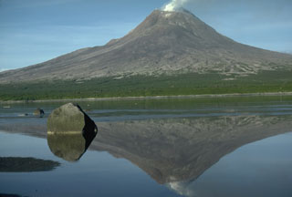
Geological Summary. Augustine volcano, rising above Kamishak Bay in the southern Cook Inlet about 290 km SW of Anchorage, is the most active volcano of the eastern Aleutian arc. It consists of a complex of overlapping summit lava domes surrounded by an apron of volcaniclastic debris that descends to the sea on all sides. Few lava flows are exposed; the flanks consist mainly of debris-avalanche and pyroclastic-flow deposits formed by repeated collapse and regrowth of the summit. The latest episode of edifice collapse occurred during Augustine's large 1883 eruption; subsequent dome growth has restored the edifice to a height comparable to that prior to 1883. The oldest dated volcanic rocks on Augustine are more than 40,000 years old. At least 11 large debris avalanches have reached the sea during the past 1,800-2,000 years, and five major pumiceous tephras have been erupted during this interval. Recorded eruptions have typically consisted of explosive activity with emplacement of pumiceous pyroclastic-flow deposits followed by lava dome extrusion with associated block-and-ash flows.
Information Contacts: Anchorage VAAC, Alaska Aviation Weather Unit, National Weather Service, 6930 Sand Lake Road, Anchorage, AK 99502, USA (URL: http://aawu.arh.noaa.gov/vaac.php); Alaska Volcano Observatory (AVO), a cooperative program of the U.S. Geological Survey, 4200 University Drive, Anchorage, AK 99508-4667, USA (URL: http://www.avo.alaska.edu/), Geophysical Institute, University of Alaska, PO Box 757320, Fairbanks, AK 99775-7320, USA, and Alaska Division of Geological & Geophysical Surveys, 794 University Ave., Suite 200, Fairbanks, AK 99709, USA; Jesse Allen, NASA Earth Observatory; Tina Neal, U.S. Geological Survey-Alaska Volcano Observatory; Ken Dean and Pavel E. Izbekov, Geophysical Institute, University of Alaska.