Report on Manam (Papua New Guinea) — February 2006

Bulletin of the Global Volcanism Network, vol. 31, no. 2 (February 2006)
Managing Editor: Richard Wunderman.
Manam (Papua New Guinea) Evacuees tempted to return; 27 February eruption reached stratosphere
Please cite this report as:
Global Volcanism Program, 2006. Report on Manam (Papua New Guinea) (Wunderman, R., ed.). Bulletin of the Global Volcanism Network, 31:2. Smithsonian Institution. https://doi.org/10.5479/si.GVP.BGVN200602-251020
Manam
Papua New Guinea
4.08°S, 145.037°E; summit elev. 1807 m
All times are local (unless otherwise noted)
Manam currently represents one of Papua New Guinea's most potent volcanic crises. It erupted several times during October-December 2004 and January 2005 (BGVN 29:10, 29:11). According to the Rabaul Volcano Observatory (RVO), the eruption on the evening of 27 January 2005 (BGVN 30:02) was the most severe activity during the current eruption period; 14 people were injured and one person killed at Warisi village (see villages in plan views of island, BGVN 30:02).
This report discusses the mild outbursts during April-May 2005, and the strong eruption on 27 February 2006. The latter eruption cloud rose into the stratosphere, ascending to a satellite-estimated altitude of 19 km. After a 9 March eruption, the press reported one elderly person missing. An eruption during the reporting interval dropped tephra on a village, forcing 49 residents to flee.
Generally mild behavior during April 2005 through mid-February 2006. Throughout April 2005, both summit craters released occasional pale gray to brown ash clouds to a few hundred meters above the summit before being blown SW, W, and NW, resulting in fine ashfall. Occasional low rumbling and roaring noises from Southern Crater were heard on 23 April and 29 April. A weak-to-moderate glow accompanied by projections of incandescent lava fragments was visible on 28 and 30 April. There were no audible noises and no night-time glow from the Main Crater. During the month, seismicity was at low-moderate levels, and tremor was occasional and weak. The daily number of low-frequency earthquakes ranged between 700 and 1,350.
A pilot reported a Manam eruption on 13 June 2005 at 0445 UTC. In addition, Darwin Volcanic Ash Advisory Centre (VAAC) reported ash plumes visible on satellite imagery during 16-17 June, 30 June, 1-2, 19, and 20 July. Imagery indicated that Manam's 19 July ash extended SW. In all instances, the heights of the plumes were not reported.
According to RVO, on 15 August, ash discharged from Southern Crater; otherwise during 15-21 August, comparatively weak volcanism prevailed and the Alert Level was reduced to Level 1. The Darwin VAAC reported a low-level plume on 22 August imagery. Mild eruptive activity continued during 22-28 August, with occasional emissions of weak-to-moderate ash plumes on several days. The ash clouds emitted on 22 and 26 August rose several hundred meters above the volcano's crater and drifted NW, depositing ash in areas between the towns of Jogari and Kuluguma, and beyond to Boisa Island.
During September weak emissions of diffuse white-gray ash clouds continued from Main Crater. On 17 September, the ash clouds increased slightly in volume and were blown to the NW part of the island. No glow was observed at night and technical problems thwarted seismic recording.
On 1 October, a pilot observed ash from Manam below ~ 3 km altitude extending NW. Ash was not visible on satellite imagery. During 3-9 October RVO reported that ash emissions continued from Main Crater. Ash clouds rose to low levels and drifted NW, depositing ash in downwind areas. RVO learned that ash was visible on satellite imagery at ~ 3 km altitude.
During the last 10 days of October, low-level eruptive activity continued at Manam with plumes visible on satellite imagery extending NW. Manam remained at Alert Level 1, indicating low levels of activity from August 2005 through December 2005.
During January 2006, mild eruptive activity occurred with occasional ash emissions during 1-4 January, and dull incandescence was visible on 1 and 2 January. Gas was emitted from Southern Crater during 1-7 January. Seismicity was at low levels during January 2006.
Large eruption of 27-28 February 2006. A large eruption began on 27 February around 1733 from Manam's Southern Crater. According to Andrew Tupper of the Darwin VAAC, satellite imagery showed an umbrella cloud above the volcano and a strong hot spot. The edges of the ash cloud were ice-rich and the eruption-plume height appeared to be about 19 km based on a warm-temperature anomaly in the middle of the cloud indicating stratospheric intrusion (figure 25).
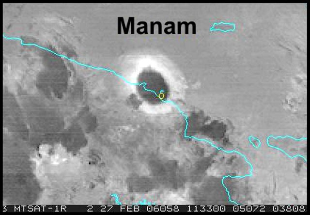 |
Figure 25. An MTSAT image of the eruption cloud over Manam captured at approximately 2145 (1145 UTC) on 27 February 2006, showing a very strong hot spot. The image contains an 11-12 ?m enhancement. In past Manam eruptions where there has been a similar white halo around the thinning umbrella cloud, the cloud has later been verified as having a large ice and SO2 content (as well as fine ash and other volcanic aerosols). The warm temperature mass persisted for 2-3 hours, suggesting a prolonged, continuing eruption. Courtesy of Andrew Tupper. |
Fred Prata processed Manam ash cloud data using the Atmospheric Infrared Sounder (AIRS, which uses a grating spectrometer on the Aqua satellite). Prata produced the atmospheric SO2 analyses in the sequential images in figures 26 and 27, which show areas of greatest concentration displaced ~ 70 and ~ 100 km W of Manam, respectively. At the bull's-eye centers, figure 26 portrays a somewhat higher peak for the product of concentration and path length (milli-atmosphere-centimeter values), ~ 60, compared to figure 27, which indicates ~ 50. Figure 27 also contains a much larger low-value area, consistent with post-eruption dispersal. The 27 February eruption clearly emitted considerable SO2, with the two analyses on figures 26 and 27 yielding respective assessed masses of 0.027 Tg and 0.054 Tg of SO2.
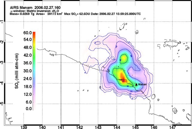 |
Figure 26. An AIRS image indicating the Manam ash plume's SO2 content at 1559 UTC on 27 February 2006. The area of detected SO2 coverage reported for this image was 59,173 km2. Further details about the image appear in the text on the image. Courtesy of Fred Prata. |
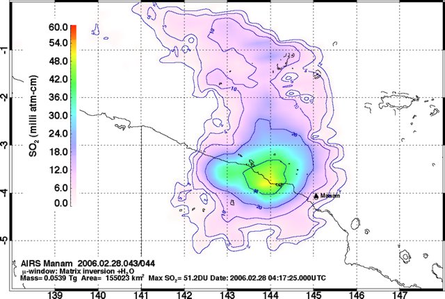 |
Figure 27. The Manam ash plume's SO2 content at 0417 UTC on 28 February 2006. The area of detected SO2 coverage reported for this image was 155,023 km2. Further details about the image appear in the text on the image. Courtesy of Fred Prata. |
RVO reported that the strong phase of the eruption declined around 0030 on 28 February. Earlier, during the height of the activity, incandescent lava fragments were thrown 700-800 m high above the volcano, but ejection heights later decreased to 200-300 m. Ash was deposited on the E part of the island and lava flowed down the SW valley. Field inspections on 28 February confirmed that a lava flow traveled down the SW valley to about 600 m elevation, a pyroclastic flow traveled down the same valley to about 500 m elevation, and the maximum ash thickness on the E part of the island was about 7-8 cm. Later, on 7 March, it was determined that pyroclastic flows had also traveled down the SE valley and that scoria and ashfall affected the area between Warisi and Bokure 1.
After mid-February, Manam's seismic station and radio communication with the observer at Bogia had both ceased operating. RVO noted that the island had been inhabited by about 300 former residents who returned to the island after evacuating following the 27 January 2005 eruption. (A March press report, below, indicated over 2,000 people on the island, including people who had previously refused to leave.) The mid-February Alert Level at the volcano was at Level 2. By 1 March, only gas was emitted from Southern Crater, no noises were heard, and weak incandescence was visible around the vent. Occasionally, incandescent lava fragments were thrown 100-150 m above the vent and fell into the crater. Main crater emitted occasional ash clouds, and then gas later in the day.
Based on information from RVO, the Darwin VAAC reported that a minor explosion occurred at Manam on 6 March. The height of the resultant plume was not reported and ash was not visible on satellite imagery. A report faxed from RVO said that during 9-11 March, both summit craters at Manam released gas, and seismicity then stood at moderate levels.
According to RVO, a recent (ambiguously disclosed) eruption had endangered about 49 people (mostly women) pelted by tephra who ran for their lives to take shelter at Dangale village to the N. The RVO team called the evacuation centers on the main island at Mangem and Asaruba where people from villages on the E part of the island were located and advised them not to go to the island unless clearance was given from the authorities. RVO warned of possible mudflows during heavy rainfall, moderate-to-high levels of seismicity, and sporadic explosions.
Press reports. On 15 March 2005 The National newspaper (online edition) reported that "[a]uthorities dispatched a vessel, the Motuan Chief, to the island [on the afternoon of 14 March] to evacuate over 2,000 islanders who had refused to move earlier or who had returned recently. A sudden explosion last Thursday [9 March] has left an elderly [man] from Wirisi village missing, believed covered by the pyroclastic [material] from the eruption . . .. Authorities . . . reported several houses burnt down from the hot emissions while others collapsed under the weight of ash dust and pyroclastic [material] . . .. [Q]uite a number of resettled people . . . have moved back to the island after an earlier evacuation and now are pleading to be evacuated back to the mainland following the recent volcanic activities.
"Some people from Warisi village who were at the [evacuation] centres on the mainland traveled back to Manam last Thursday to gather food from their gardens. They were to return to the [evacuation] centre but unfortunately their boat . . . was destroyed by rocks from the eruption."
A January 2006 article in the PNG Post-Courier (and online in the Pacific Islands Report) noted that the Red Cross and Red Crescent Societies had spent about US $377,000 on emergency aid for resettlement camps on the main island. The article noted that aid societies had helped the government, funding 350 houses constructed of bush-materials at the camps since October 2004. Those camps (also termed care centers) include Mangem, Asuramba (Asaruba?), and Potsdam.
Geological Summary. The 10-km-wide island of Manam, lying 13 km off the northern coast of mainland Papua New Guinea, is one of the country's most active volcanoes. Four large radial valleys extend from the unvegetated summit of the conical basaltic-andesitic stratovolcano to its lower flanks. These valleys channel lava flows and pyroclastic avalanches that have sometimes reached the coast. Five small satellitic centers are located near the island's shoreline on the northern, southern, and western sides. Two summit craters are present; both are active, although most observed eruptions have originated from the southern crater, concentrating eruptive products during much of the past century into the SE valley. Frequent eruptions, typically of mild-to-moderate scale, have been recorded since 1616. Occasional larger eruptions have produced pyroclastic flows and lava flows that reached flat-lying coastal areas and entered the sea, sometimes impacting populated areas.
Information Contacts: Ima Itikarai, Rabaul Volcano Observatory (RVO), P.O. Box 386, Rabaul, Papua New Guinea; Andrew Tupper, Darwin Volcanic Ash Advisory Centre (VAAC), Bureau of Meteorology, Northern Territory Regional Office, PO Box 40050, Casuarina, Northern Territory 0811, Australia (URL: http://www.bom.gov.au/info/vaac/); Bonney Bonsella and Thomas Kilala, The National Online, Lot 13 Section 38, Waigani Drive Hohola, PO Box 6817 Boroko, National Capital District, Papua New Guinea (URL: http://www.thenational.com.pg/); PNG Post-Courier; Pacific Islands Report.