Report on Tinakula (Solomon Islands) — March 2006
Bulletin of the Global Volcanism Network, vol. 31, no. 3 (March 2006)
Managing Editor: Richard Wunderman.
Tinakula (Solomon Islands) Eruption; increased thermal anomalies during February-April 2006
Please cite this report as:
Global Volcanism Program, 2006. Report on Tinakula (Solomon Islands) (Wunderman, R., ed.). Bulletin of the Global Volcanism Network, 31:3. Smithsonian Institution. https://doi.org/10.5479/si.GVP.BGVN200603-256010
Tinakula
Solomon Islands
10.386°S, 165.804°E; summit elev. 796 m
All times are local (unless otherwise noted)
According to Simon Carn, volcanic activity at Tinakula appears to have begun on 12 February 2006, with a small explosion followed by degassing. He noted some significant SO2 emissions on 14 February, as well as small plumes from Ambrym and Aoba. As of 16 February, there was still a small SO2 signal from Tinakula, but it was no bigger than that from Ambrym or Aoba. Andrew Tupper noted from visible MTSAT (Multi-functional Transport Satellite) images and an Aqua MODIS (Moderate Resolution Imaging Spectroradiometer) screen shot that a plume on 14 February was moving NNE at ~ 10 km/hour and appeared to be not far above summit level; the plume did not register on the IR imagery. MTSAT is a dual-mission satellite for the Japan Ministry of Land, Infrastructure, and Transport and the Japan Meteorological Agency performing an air traffic control and navigation, as well as a meteorological, functions.
On 27 February, Thomas Toba of the Solomon Islands government wrote to Herman Patia of the Rabaul Volcano Observatory, confirming Tinakula activity. Toba contacted authorities from the Temotu Provincial Headquarters who confirmed that there were several small explosions from this volcano around early to middle February 2006.
Satellite thermal-sensor data (using the MODVOLC alert-detection algorithm) revealed a period of thermal anomalies on the uninhabited island of Tinakula during cloud-free intervals in early to mid-February 2006 (table 1). The anomalies were particularly numerous on 11 February. The information was extracted from the MODIS Thermal Alerts website maintained by the Hawai'i Institute of Geophysics and Planetology (HIGP) (see also BGVN 29:06 and 28:01). The satellites used were Aqua and Terra MODIS. Confirmation of the volcanic source of the anomalies was not broadly distributed until late March 2006.
Table 1. MODVOLC thermal anomalies at Tinakula for mid-February through mid-April 2006. Since the start of monitoring by MODIS satellite sensors on 8 May 2001, no thermal anomalies had been measured at Tinakula before 11 February 2006. Courtesy of University of Hawai'i Institute of Geophysics and Planetology MODIS Hotspot Alert website.
| Date | Time (UTC) | Pixels | Satellite |
| 11 Feb 2006 | 1125 | 6 | Terra |
| 11 Feb 2006 | 1425 | 10 | Aqua |
| 11 Feb 2006 | 2350 | 3 | Terra |
| 12 Feb 2006 | 0240 | 4 | Aqua |
| 13 Feb 2006 | 2340 | 3 | Terra |
| 15 Feb 2006 | 1500 | 2 | Aqua |
| 18 Feb 2006 | 1430 | 2 | Aqua |
| 03 Mar 2006 | 2325 | 1 | Terra |
| 06 Mar 2006 | 1430 | 1 | Aqua |
| 08 Mar 2006 | 1120 | 1 | Terra |
| 08 Mar 2006 | 1420 | 2 | Aqua |
| 13 Mar 2006 | 1135 | 1 | Terra |
| 15 Mar 2006 | 1425 | 1 | Aqua |
| 20 Mar 2006 | 1145 | 1 | Terra |
| 09 Apr 2006 | 1420 | 1 | Aqua |
| 14 Apr 2006 | 1135 | 1 | Terra |
| 16 Apr 2006 | 1125 | 2 | Terra |
| 16 Apr 2006 | 1425 | 1 | Aqua |
| 18 Apr 2006 | 1410 | 3 | Aqua |
| 19 Apr 2006 | 1455 | 1 | Aqua |
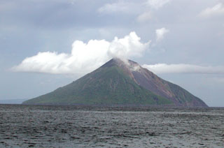
Geological Summary. The small 3.5-km-wide island of Tinakula is the exposed summit of a massive stratovolcano at the NW end of the Santa Cruz islands. It has a breached summit crater that extends from the summit to below sea level. Landslides enlarged this scarp in 1965, creating an embayment on the NW coast. The Mendana cone is located on the SE side. The dominantly andesitic volcano has frequently been observed in eruption since the era of Spanish exploration began in 1595. In about 1840, an explosive eruption apparently produced pyroclastic flows that swept all sides of the island, killing its inhabitants. Recorded eruptions have frequently originated from a cone constructed within the large breached crater. These have left the upper flanks and the steep apron of lava flows and volcaniclastic debris within the breach unvegetated.
Information Contacts: Hawai'i Institute of Geophysics and Planetology (HIGP), School of Ocean and Earth Science and Technology, University of Hawai'i at Manoa, 1680 East-West Road, POST 602, Honolulu, HI 96822 (URL: http://modis.higp.hawaii.edu); Simon Carn, University of Maryland Baltimore County (UMBC), Joint Center for Earth Systems Technology (JCET), Total Ozone Mapping Spectrometer (TOMS) Volcanic Emissions Group, 1000 Hilltop Circle, Baltimore, MD 21250; Andrew Tupper, Darwin Volcanic Ash Advisory Centre, Bureau of Meteorology, Australia (URL: http://www.bom.gov.au/info/vaac/); Thomas Toba, Ministry of Energy, Water, and Minerals Resources, Honiara, Solomon Islands; Herman Patia, Rabaul Volcano Observatory, P.O. Box 386, Rabaul, Papua New Guinea.