Report on Sulu Range (Papua New Guinea) — July 2006
Bulletin of the Global Volcanism Network, vol. 31, no. 7 (July 2006)
Managing Editor: Richard Wunderman.
Sulu Range (Papua New Guinea) Seismicity and emissions reported from volcano with no historical eruptions
Please cite this report as:
Global Volcanism Program, 2006. Report on Sulu Range (Papua New Guinea) (Wunderman, R., ed.). Bulletin of the Global Volcanism Network, 31:7. Smithsonian Institution. https://doi.org/10.5479/si.GVP.BGVN200607-252090
Sulu Range
Papua New Guinea
5.5°S, 150.942°E; summit elev. 610 m
All times are local (unless otherwise noted)
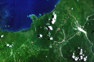
On 7 July 2006, observers reported the first historical indication of volcanic activity in the Sulu Range of New Britain (in the nation of Papua New Guinea (PNG)). As shown on figure 1, the Sulu Range lies near the N coast of New Britain Island. This spot sits in the Province of West New Britain but in terms of geometry, lies closer to the middle of the island ~100 km E of the prominent, N-trending Willaumez Peninsula and ~200 km SW of Rabaul at the island's E end.
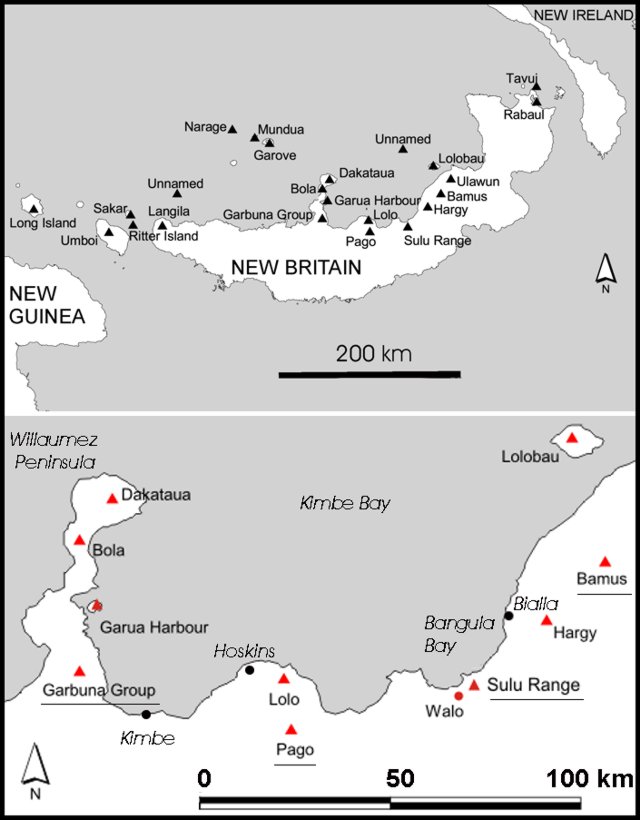 |
Figure 1. Two maps indicating the context of the Sulu Range on New Britain Island. Volcanoes with currently listed Holocene activity are shown (solid triangles). (Top map) Covering all of New Britain and parts of neighboring islands New Guinea and New Ireland. Four volcanoes in this region have become active in the past few years: Garbuna, Pago, Sulu Range, and Bamus. In the cases of Garbuna and the Sulu Range, these were their first recorded historical eruptions. Beyond Bamus to the NE reside the better known Ulawun and Rabaul volcanoes. (Lower map) An enlargement of the area bounded to the W by the Willaumez Peninsula. |
Rabaul Volcano Observatory (RVO) noted that ground observations at the Sulu Range, confirmed by aerial inspection, indicated that the emissions were coming from an area initially incorrectly disclosed as Mount Karai. (Karai is reportedly equivalent to Mount Ruckenberg, mentioned below.) Later reports correcting the initial vent location, stated that the eruption took place 2 km SW of Mount Karai between Ubia and Ululu volcanoes.
Considerable light on the Sulu Range and other volcanoes in the vicinity is shed by an Australian Bureau of Mineral Resources report by Johnson (1971). The coordinates and summit elevation given in the header above apply to the highest point in the Sulu Range, Mount Malopu (synonyms include "Malutu" and "Malobu").
Changes in our nomenclature. We indicate Walo hot springs on the lower map of figure 1, the only feature in this vicinity previously identified in our database on active volcanoes. Walo was listed as a thermal feature in the Melanesian portion of the Catalog of Active Volcanoes of the World (Fisher, 1957) and in Simkin and Siebert (1994). Walo rests in a low swampy area ~ 3 km W of the edge of the Sulu Range, which we apply broadly to a ~ 10 km diameter mountainous area with multiple peaks of ~ 500-600 m elevation. The highland areas associated with the Sulu Range's NE end contains a cone near the coast, which is labeled "Mount Ruckenberg (extinct volcano)" on the Bangula Sheet (Papua New Guinea 1:100,000 Topographic Survey, 1975).
The Sulu Range eruption has spurred restructuring of our naming conventions. Walo is now listed as a thermal feature associated with the larger volcanic field called the Sulu Range (and it preserves the Volcano Number that used to apply only to Walo, 0502-09=).
2006 eruption and earthquakes. RVO reported that there were indications as early as February 2006 that something was changing at Sulu Range because vegetation there was dying off. RVO noted that earthquakes began on 6 July and most river systems near Mount Karai had turned muddy due to the continuous shaking. Seismic activity was followed by the emission of puffs of white vapor from the area and loud booming and rumbling noises accompanied strong tremors.
Eruptions started with forceful dark emissions late on 7 and 8 July and decreased to moderate emissions by 10 July. At the settlement Bialla, ~20 km NE of the Sulu Range, tremors were felt. These were also picked up by the seismic stations at Garbuna and Ulawun (~100 km W and ENE, respectively).
In a report discussing 10-11 July, RVO reported that three villages N of Mount Karai had been evacuated. For the 10th, RVO described the activity as weak-to-moderate emission of white vapor with no evidence of ashfall and with occasional weak-to-moderate roaring noises accompanying the emissions. On the 11th, associated with earthquakes, white puffs discharged. Similar observations of white emissions prevailed through the 12th.
Earthquakes increased both in size and frequency of occurrence, and on 11 July at Bialla they took place every 10-20 minutes. Near Ubia volcano, seismicity was very elevated, with earthquakes every few minutes. At 0820 on 12 July a large earthquake of Modified Mercalli (MM) intensity VII or more occurred in the region. It disturbed the shoreline, which discolored the seawater; shaking also caused the sea surface to become choppy.
The USGS epicenter for the above-cited 12 July (local time) earthquake was listed at very nearly the same time (in UTC, on 11 July at 2222) with epicenter at 5.48°S, 150.83°E, a depth of 37 km and a body magnitude (mb) of 4.90. That spot lies 12 km NE of Sulu Range (using the coordinates listed in the header above). On a table of earthquakes the same day (11 July, UTC), seven others, mb 3.9-4.7 occurred within several hundred kilometers of Sulu Range. All took place earlier, but a pattern of substantial ongoing earthquakes also prevailed later as well.
RVO noted that from 1600 on 12 July to 0900 on 13 July high-frequency earthquakes occurring at the rate of one every minute were recorded on the seismograph deployed at Bialla. The earthquakes recorded were of varying (though unstated) magnitudes and towards 0900 decreased slightly to one every 30 minutes. Shortly afterwards, from 1000 to 1400 on 13 July, the seismograph was deployed in Kaiamu village on the small point immediately NW of the uplands portions of the Sulu Range, where it recorded continuous strings of high frequency earthquakes. Although the instrument was out of service after 1400 on the 13th, recording resumed that afternoon and seismic activity continued at a high level through 0900 on 15 July. During this time, the occurrence of felt earthquakes with maximum MM intensity V increased from one every 40-60 minutes to one every 2-3 minutes. Details of a subsequent decline in seismicity are sketchy.
The last reported visible emissions from the Sulu Range were on 12 July. By early August 2006 seismic activity had decreased to earthquakes of MM intensity I to II occurring at increasing intervals.
Again referring to USGS seismicity tables, the previously mentioned pattern of ongoing earthquakes on 11 July, generally mb 3.9-4.9, continued. An exception, the largest magnitude event during 9-18 July struck 31 km from Sulu Range, listed in UTC on 13 July at 2248; mb 5.1. It was at 39 km depth with epicenter ~12 km away. About 5 hours later a mb 4.7 event was recorded directly at volcano. On the 19th two larger earthquakes struck. One an Ms 6.4 centered 28 km away; the second, an Mw 5.90, 33 km away. These were the largest earthquakes within 50 km during 1 July to 11 September 2006.
References. Fisher N H, 1957, Melanesia: Catalog of Active Volcanoes of the World and Solfatara Fields, Rome, IAVCEI, v. 5, p. 1-105.
Johnson, R.W., 1971, Bamus volcano, Lake Hargy area, and Sulu Range, New Britain: Volcanic geology and petrology, Aust. Bur. Min. Res. Geol. Geophys. Rec, 1971/55, p. 1-36.
Papua New Guinea 1:100,000 Topographic Survey, 1975, Bangula Sheet, Sheet 9187, Series T601: Royal Australian Survey Corps (Reprinted by the National Mapping Bureau, 1985).
Simkin, T., and Siebert, L., 1994, Volcanoes of the World: Geoscience Press, Tucson, Arizona, 349 p. (ISBN 0-945005-12-1).
Geological Summary. The Sulu Range consists of a cluster of partially overlapping small stratovolcanoes and lava domes in north-central New Britain off Bangula Bay. The 610-m Mount Malopu at the southern end forms the high point of the basaltic-to-rhyolitic complex. Kaiamu maar forms a peninsula with a small lake extending about 1 km into Bangula Bay at the NW side of the Sulu Range. The Walo hydrothermal area, consisting of solfataras and mud pots, lies on the coastal plain west of the SW base of the Sulu Range. No historical eruptions are known from the Sulu Range, although some of the cones display a relatively undissected morphology. A vigorous new fumarolic vent opened in 2006, preceded by vegetation die-off, seismicity, and dust-producing landslides.
Information Contacts: Herman Patia and Steve Saunders, Rabaul Volcano Observatory (RVO), P.O. Box 386, Rabaul, Papua New Guinea.