Report on Mayon (Philippines) — August 2006

Bulletin of the Global Volcanism Network, vol. 31, no. 8 (August 2006)
Managing Editor: Richard Wunderman.
Mayon (Philippines) Lava extruding but with less vigor
Please cite this report as:
Global Volcanism Program, 2006. Report on Mayon (Philippines) (Wunderman, R., ed.). Bulletin of the Global Volcanism Network, 31:8. Smithsonian Institution. https://doi.org/10.5479/si.GVP.BGVN200608-273030
Mayon
Philippines
13.257°N, 123.685°E; summit elev. 2462 m
All times are local (unless otherwise noted)
During 6 September to 3 October 2006, the Philippine Institute of Volcanology and Seismology (PHIVOLCS) described lava extrusion and associated rockfalls on Mayon's SE slopes. This continued the previous pattern seen during 23 August-5 September 2006 (BGVN 31:07). Mayon's eruptive vigor generally declined by mid-September into October. Background on Mayon's geography follows (figures 13-15 and table 9).
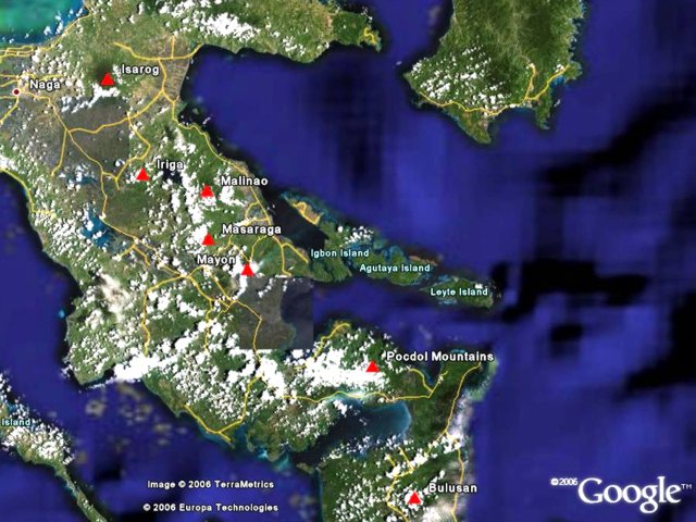 |
Figure 13. Satellite image of the SE area of the Philippine island of Luzon showing Mayon volcano and surrounding volcanoes and towns. Courtesy of Google Earth. |
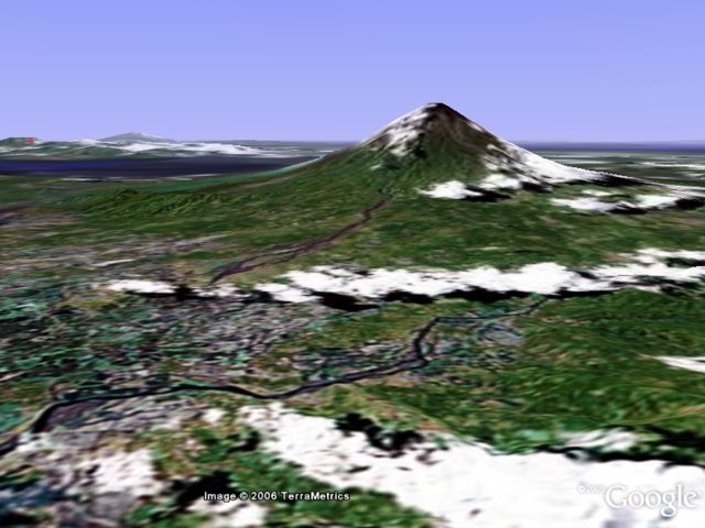 |
Figure 14. Oblique aerial image of Mayon, looking from the N at an eye altitude of 1.78 km. Courtesy of Google Earth. |
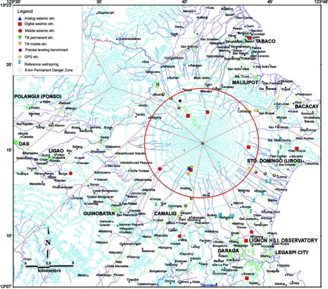 |
Figure 15. Contour map of Mayon volcano showing surrounding towns (see table 9 for more detailed list of names of nearby settlements) . The prominent circle around the volcano delineates the 6-km Permanent Danger Zone. Scale is 1:50,000. Courtesy of PHIVOLCS. |
Table 9. An alphabetical list including some of the settlements and other place names on and surrounding Mayon volcano, and their bearings and distances from the summit. Taken from the PHIVOLCS map referenced below.
| Town Name | Bearing | Distance (km) |
| Alcala | SSE | 9.6 |
| Amtic | NW | 7.7 |
| Anoling | SSW | 6.1 |
| Arimbay | SE | 10.9 |
| Bacacay | ENE | 12 |
| Baligang | WNW | 6.2 |
| Banadero | S | 8 |
| Bantayan | NNW | 9.5 |
| Baranghawon | NNE | 11.4 |
| Basag | W | 9.6 |
| Basagan | N | 8.8 |
| Bigaa | ESE | 10.1 |
| Binanowan | W | 10.7 |
| Binitayan | NE | 10.5 |
| Binogsacan | SW | 12.5 |
| Bonga | SE | 8.5 |
| Bongabong | NNE | 9.3 |
| Bono? | NNW | 7.8 |
| Boring | N | 8.2 |
| Buang | NW | 7.4 |
| Bubulusan | WSW | 10.3 |
| Budiao | S | 8.1 |
| Buhian | NNW | 8.3 |
| Burabod | SE | 9.9 |
| Buyuan | SE | 8.1 |
| Cabangan | SSW | 8.1 |
| Cagsawa | S | 10 |
| Calbayog | NE | 6.5 |
| Camalig | S | 8.8 |
| Canaway | NNE | 7.6 |
| Comon | N | 6.8 |
| Daraga | SSE | 12.2 |
| Dita | SE | 10.3 |
| Dona Tomasa | WSW | 8.5 |
| Fidel Surtida | E | 9.9 |
| Guinobat | N | 11 |
| Guinobatan | SW | 11.8 |
| Hindi | NE | 10.4 |
| Ilawod | SW | 11.5 |
| Kilicao | SSE | 10.3 |
| Legaspi City | SSE | 13.5 |
| Libod | SSW | 10 |
| Lidong | ESE | 8.7 |
| Ligao | W | 14 |
| Lower Bonga | ENE | 8.1 |
| Mabinet | SSE | 8.5 |
| Magapo | NW | 5.7 |
| Maipon | SW | 10 |
| Malilipot | NE | 9 |
| Maninila | SW | 8.1 |
| Mariroc | N | 9.7 |
| Masarawag | SW | 8.1 |
| Matagbac | N | 11 |
| Matanag | SE | 8.4 |
| Matnog | SSE | 8.4 |
| Mayon Rest House Observatory | NW | 3.6 |
| Miisi | S | 6 |
| Muladbucad Grande | W | 8.9 |
| Muladbucad Pequeno | W | 8.8 |
| Nabonton | W | 10.3 |
| Nasisi | W | 10.8 |
| Oson | N | 7.3 |
| Padang | ESE | 9.4 |
| Pingabobong | N | 8.3 |
| Quinastillohan | N | 10 |
| Quirangay | SSW | 7.3 |
| Rawis | SSE | 11.7 |
| Sabinitayan | NE | 10.5 |
| Salugan | SSW | 7.8 |
| Salvacion | S | 8.6 |
| San Andres | E | 10.4 |
| San Antonio | N | 10.2 |
| San Fernando | E | 8.2 |
| San Francisco | NE | 8.8 |
| San Isidro | NNE | 9.3 |
| San Joaquin | SE | 11 |
| San Lorenzo | NNE | 11.7 |
| San Rafael | SW | 10.8 |
| San Roque | E | 8.8 |
| San Vincente | N | 11.4 |
| Sta. Misericordia | E | 8.2 |
| Sta. Misericordia Observatory | E | 7.9 |
| Sta. Cruz | NNE | 8.7 |
| Sto. Domingo | ESE | 10 |
| Sua | SSW | 8.1 |
| Sugod | NE | 10.6 |
| Tabaco | NNE | 12.5 |
| Tabiguian | NW | 8.8 |
| Tagas | NNE | 11.2 |
| Tambo | WNW | 7.9 |
| Tandarora | SW | 9.4 |
| Travesia | SW | 10.8 |
| Tumpa | SW | 8 |
| Upper Bongo | ENE | 8.3 |
Seismicity and lava extrusion generally decreased during 6-26 September. SO2 fluxes broadly declined, generally ranging between 1,200 and 3,000 tons per day, although the 25 August and 2 September readings were outliers, ~ 5,400 and ~ 6,600 tons per day, respectively. Ground-deformation measurements showed an overall deflation. On 11 September, the Alert Level was lowered from 4 to 3 (on a scale of 0-5, with 0 referring to No Alert status).
During late September surface activity was characterized by intermittent spalling of incandescent lava fragments and glow from the summit crater. Steaming at the summit was moderate with white plumes drifting NNE and SE. Low-frequency tremor continued to indicate elevated unrest. Alert Level 3 remained in effect, meaning that the new Extended Danger Zone (EDZ) of 7 km from the summit crater in the SE sector and the normal 6 km-radius Permanent Danger Zone (PDZ) for other areas continued. Table 10 lists Mayon's reported seismicity from 25 August-27 September 2006, continuing the list developed in BGVN 31:07.
Table 10. Summary of 25 August-3 October 2006 events observed at Mayon volcano for 24-hour periods ending at 0800 hours on the date indicated. The SO2 emission rates apply to the gas within the volcanic plume. No data was available for 10, 28, or 29 September. Courtesy of PHIVOLCS.
| Date | Volcanic Earthquakes | Tremor Episodes | Low-frequency Harmonic Tremor | SO2 Emission Rate (tons/day) | Comments |
| 25 Aug 2006 | 17 | 303 | -- | 5401 (magma degassing) | Mild state of eruption, Alert Level 4. |
| 01 Sep 2006 | 25 | 277 | -- | -- | Lava extrusion, four explosions. |
| 02 Sep 2006 | 31 | 248p | -- | 6585 (high) | Small explosion. |
| 03 Sep 2006 | 9 | high | -- | 2021 | -- |
| 04 Sep 2006 | -- | 305 | -- | 2961 | -- |
| 05 Sep 2006 | 0 | 455 | -- | 1447 | -- |
| 06 Sep 2006 | 13 | 295 | -- | 2032 | -- |
| 07 Sep 2006 | 10 | 315 | -- | -- | -- |
| 08 Sep 2006 | 26 | 333 | -- | 1841 | -- |
| 09 Sep 2006 | 2 | 300 | -- | 1701 | -- |
| 11 Sep 2006 | 6 | 206 | -- | 1500 | -- |
| 12 Sep 2006 | 0 | 253 | -- | 1500 | Begin Alert Level 3. |
| 13 Sep 2006 | 8 | 108 | -- | 1500 | -- |
| 14 Sep 2006 | 18 | 111 | -- | 1500 | -- |
| 15 Sep 2006 | 12 | 104 | continuous | 1600 | -- |
| 16 Sep 2006 | 2 | 31 | continuous | 1400 | -- |
| 17 Sep 2006 | -- | 57 | -- | 1800 | -- |
| 18 Sep 2006 | 2 | 57 | continuous | 1500 | -- |
| 19 Sep 2006 | -- | 47 | -- | 1500 | -- |
| 20 Sep 2006 | 1 | 33 | continuous | 1200 | -- |
| 21 Sep 2006 | 3 | 20 | continuous | 2200 | -- |
| 22 Sep 2006 | 2 | 80 | continuous | 1600 | Lava extrusion. |
| 23 Sep 2006 | 1 | 14 | continuous | 1599 | Decline in lava extrusion. |
| 24 Sep 2006 | 6 | 21 | continuous | -- | Intense crater glow. |
| 25 Sep 2006 | 14 | 114 | -- | 1300 | Crater glow, lava extrusion. |
| 26 Sep 2006 | 12 | 65 | -- | 1200 | -- |
| 27 Sep 2006 | 7 | 18 | -- | None measured due to rain. | Crater glow, lava fragments. |
| 30 Sep 2006 | 0 | 3 | -- | None measured due to weather. | White plumes drifting ENE. |
| 01 Oct 2006 | 0 | 0 | -- | None measured due to weather. | White plumes drifting ENE. |
| 02 Oct 2006 | 0 | 0 | -- | None measured due to weather. | -- |
| 03 Oct 2006 | 0 | 0 | -- | -- | -- |
Reference. PHIVOLCS, (date unknown), Geologic map of the deposits and features of the 1984 eruption of Mayon Volcano: PHIVOLCS, prepared by H.B. Ruelo, scale 1:50,000.
Geological Summary. Symmetrical Mayon, which rises above the Albay Gulf NW of Legazpi City, is the most active volcano of the Philippines. The steep upper slopes are capped by a small summit crater. Recorded eruptions since 1616 CE range from Strombolian to basaltic Plinian, with cyclical activity beginning with basaltic eruptions, followed by longer periods of andesitic lava flows. Eruptions occur predominately from the central conduit and have also produced lava flows that travel far down the flanks. Pyroclastic density currents and mudflows have commonly swept down many of the approximately 40 ravines that radiate from the summit and have often damaged populated lowland areas. A violent eruption in 1814 killed more than 1,200 people and devastated several towns.
Information Contacts: Philippine Institute of Volcanology and Seismology (PHIVOLCS), University of the Philippines Campus, Diliman, Quezon City, Philippines (URL: http://www.phivolcs.dost.gov.ph/).