Report on Home Reef (Tonga) — September 2006
Bulletin of the Global Volcanism Network, vol. 31, no. 9 (September 2006)
Managing Editor: Richard Wunderman.
Home Reef (Tonga) Extensive pumice rafts between Tonga and Fiji during August-October
Please cite this report as:
Global Volcanism Program, 2006. Report on Home Reef (Tonga) (Wunderman, R., ed.). Bulletin of the Global Volcanism Network, 31:9. Smithsonian Institution. https://doi.org/10.5479/si.GVP.BGVN200609-243080
Home Reef
Tonga
18.992°S, 174.775°W; summit elev. -10 m
All times are local (unless otherwise noted)
Pumice rafts drifting from Tonga to Fiji occurred during August-October 2006. The source of these pumice rafts was Home Reef, which was first observed to be in eruption on 9 August and was clearly building an island by 12 August (figure 2). A compilation of report sightings through mid-October 2006, plotted using Google Earth, shows the timing and distribution of the pumice rafts that are discussed in this report (figure 3). As is our convention, and as available, a list of contributors (and their vessels) is noted in last section of this report.
Pumice traveled both N and S around Fiji's Lau Group. To the N, pumice reached Taveuni through the Nanuku passage and entered the Koro sea, washing onto southern Vanua Levu, before moving into the Bligh Waters N of Viti Levu by 20 September. To the S, extensive pumice was seen N of Vatoa Island on 16 September, and on Kadavu Island by the end of the month. Pumice was also encountered by the Encore II W of Viti Levu on 30 September while enroute to New Caledonia.
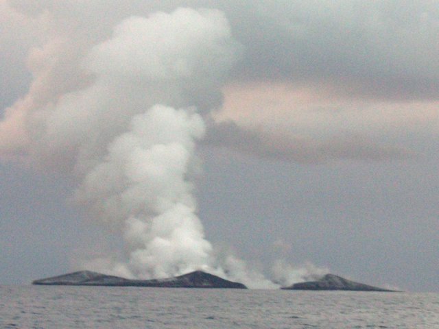 |
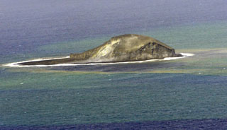
Figure 2. Photograph of the new island being built by the eruption at Home Reef as seen on 12 August 2006. The island was ~1.5 km in diameter. View is towards the W from about 2.8 km away. Courtesy of Fredrik Fransson of the Maiken. |
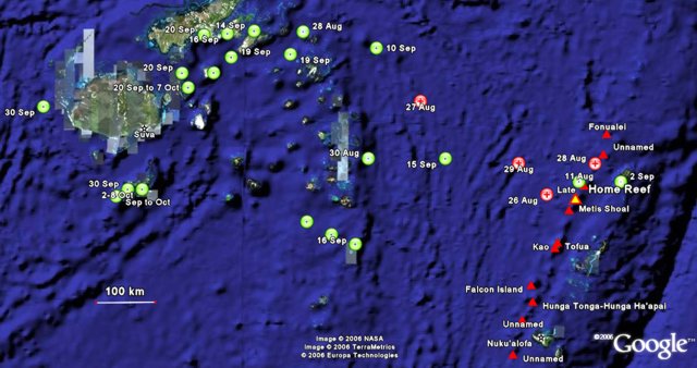 |
Figure 3. Map of Tonga (right) and Fiji (upper left) showing dates and locations where observers saw pumice rafts (placemarks with dots) or where mariners crossing between Tonga and Fiji failed to see rafts (placemarks with crosses). Some locations are approximate; see text for additional details and sources of each observation. The base map is from Google Earth with points plotted by Bulletin editors. |
Early observations of the eruption. The news service Matangi Tonga Online quoted Allan Bowe, the owner of the Mounu Island Resort in southern Vava'u, regarding volcanic activity in the direction of Home Reef during 9-11 August. Bowe heard ". . . what sounded like continuous thunder rumbling to the S and there was a huge plume of smoke and cloud rising up into the sky." In another Matangi news article, Siaosi Fenukitau, a captain of one of the fishing boats of the Maritime Projects Co. (Tonga) Ltd., reported that around mid-September they sighted a new volcanic island near Home Reef that was larger than Fotuha'a, a small island in Ha'apai with a population of about 134 people.
The yacht Maiken left Neiafu on 11 August, passing the N side of Late Island. After about 9 km the crew noticed brown, somewhat grainy streaks in the water. The streaks became larger and more frequent as they continued SW "until the whole horizon was a solid line to what looked like a desert." The brownish pumice fragments the size of a fist were floating in water that was strangely green. They motored into the vast (many miles wide) belt of densely packed pumice, and within seconds Maiken slowed down from seven to one knot. Initially the thin layer on the surface was pushed away by the bow wave, but when they entered the solid field it started to pile up and "behaved like wet concrete" and "looked like rolling sand dunes as far as the eye could see." After retreating from the pumice with only minor paint abrasion along the waterline, and then cleaning their intake filters, they decided to anchor in Vaiutukakau bay outside Vava'u for the night. The next morning, 12 August, they received radio confirmation of an eruption, but the vent and extent were uncertain. They decided to go S to avoid the pumice rafts floating NW, heading SSW until they encountered the pumice, then sailing alongside until the rafts were broken up enough to safely travel through.
As they approached Home Reef it became clear that one of the clouds on the horizon was a volcanic plume. Observations from a closer vantage point revealed that an intermittent "massive black pillar shot upwards toward the sky" and particles were raining down. Since the wind was pushing the plume NW, the Maiken motored up to within 2.8 km of the island (to 18°59.5'S, 174°46.3'W) while the sun was going down. Multiple peaks forming a crater open to the sea on one side were visible, and it looked like it was "made of black coal." Not wanting to encounter more pumice rafts after dark, they continued SSW towards the southern part of the Lau Group.
Pumice sightings between Tonga and Fiji. Boats that later noted seeing pumice in Fiji did not report any activity or rafts near Tonga during 27-29 August. The Soren Larsen sailed through "a sea of floating pumice" one evening that "sounded like we were sailing through ice" just before reaching Fiji. This encounter was probably on 30 August when their online tracker located the ship just W of the central Lau islands after departing Neiafu on the 28th. No eruptive activity or pumice was noted in the online log of the Soren Larsen for 14-15 and 23-24 August when they transited to northern Tonga to the E of Home Reef.
While the Encore II crew was visiting the Mounu Island Resort on 2 September there were "grapefruit-sized" pumice pieces on the beach. A few days later, while listening to the "Rag of the Air" net broadcast out of Fiji, the Encore II crew learned of pumice rafts along their expected route. The operator of this broadcast, Jim Bandy, provides weather reports for boats going between Tonga and Fiji. One report was of a mass of pumice about 11 km long and at least a meter ("many feet") deep. The Encore II departed from Neiafu on 8 September on a course around a set of Fijian islands and reefs called the Lau Group. The crew believed that this route, going NW around the Lau Group, helped them avoid most of the pumice.
As the Encore II approached their turning point about two thirds of the way to Fiji, on 10 September, they encountered "rivers of pumice" floating roughly parallel to their NW course due to the SE winds (figure 4). Some pumice fragments that they collected were about 5-10 cm in diameter, although most were about the size of pea gravel. The parallel streams of pumice, only a single layer in depth, were sometimes up to 90 m wide and 400 m long. The crew later heard reports from several boats that had taken a more westerly route through the Lau Group to Fiji and encountered much larger areas of pumice. The crew on the Norwegian sailboat Stormsvalen went through larger and thicker areas of pumice, leaving a track in the pumice as they went through (figures 5 and 6). They noted that boats traveling through the pumice during higher winds and seas encountered a problem of airborne pumice pelting the crews and their boats. One crew reported pumice covering their deck.
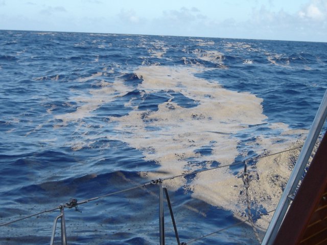 |
Figure 4. Photograph showing small areas of floating pumice just NE of the Lau Group of islands, Fiji, around 10 September 2006. Courtesy of the Encore II crew. |
 |
Figure 5. Photograph showing a large pumice raft near the Lau Group of islands, Fiji, on an unknown date in early to mid-September 2006. Courtesy of the Stormsvalen crew via the Encore II. |
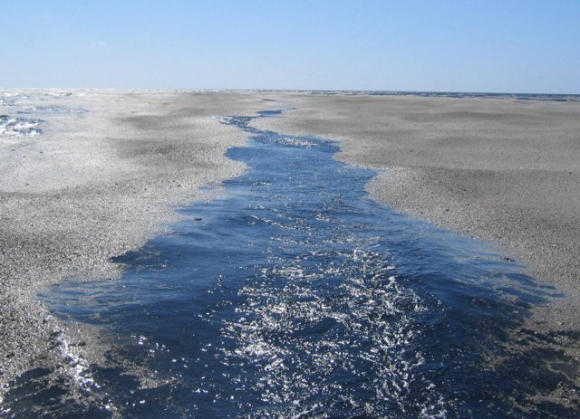 |
Figure 6. View of a large pumice raft after the passage of a sailing vessel near the Lau Group of islands, Fiji, on an unknown date in early to mid-September 2006. Courtesy of the Stormsvalen crew via the Encore II. |
A sailboat blog entry by Sara Berman and Jean Philippe Chabot noted a "strong sulfur odor" in the direction of the volcano upon leaving Tongan waters around 20 September. As they progressed SW towards Fiji they passed through streams of pumice containing pieces ranging from very small pebbles to larger pieces the size of a baseball. Every time a wave crashed on deck they heard the pumice making its way onto the boat and into the cockpit.On 30 September the Windbird log noted that ". . . cruisers are still having to avoid the huge pumice field that is floating about between Tonga and Fiji."
Bob McDavitt's "Weathergram" for 15 October noted that reports from yachts sailing between Tonga and Fiji indicated an absence of pumice. These observations suggest that the bulk of material produced by the eruption, or series of eruptions, had crossed to Fiji by mid-October.
Pumice rafts in northern Fiji. The earliest known direct observations of the floating pumice in Fiji come from a boat with callsign KB1LSY, the crew of which noted that "thick pumice" slowed them to 2 knots for 30 minutes during the early morning hours of 28 August. This occurred as they approached the northern islands of the Lau Group in Fiji, about 500 km NW of Home Reef.
According to Roberta Davis, the pumice arrived at Taveuni, Fiji, on 14 September. There were several rafts ~300 m from shore with other rafts scattered farther out. Local mariners noted that pieces in the top layer were approximately the size of pea gravel. Suspended below the surface were pieces almost as large as footballs. The beaches on the northern shores of Taveuni were covered in what appeared to be black popcorn. The pumice was present at Taveuni for up to 6 days.
On 19 September David Forsythe reported that large rafts of pumice were passing through the northern Lau group in Fiji (figure 7). He noted gooseneck barnacles up to 10 mm long on the largest pieces. Bulletin editors found compiled growth rates for various stalked barnacles ( Thiel and Gutow, 2005), which indicated 17-29 days of growth.
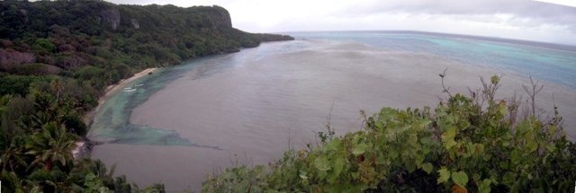 |
Figure 7. Panoramic view of Indigo Swan Beach filled with pumice, Naitauba Island, Fiji, as seen in September 2006. Courtesy of David Forsythe. |
The Encore II crew observed pumice along the S side of Vanua Levu, W of the Lau Group, around 16 September. They noted pumice at Fawn Harbour that obscured the channel into the harbor and it made a boat at anchor appear to be aground on an island. They also observed streams of pumice near the Makogai Channel on 20 September. The Fiji Times Online reported on 20 September that villagers living along the coastal areas of Saqani in Cakaudrove (Vanua Levu) were battling to clear their pumice-covered seashores and rivers. Villagers saw the pumice floating in the sea near their homes on 18 September, and by the next day the pumice covered the river and villagers could not fish or travel by boats and bamboo rafts to their plantations.
While diving at the "Bligh Triangle" of Fiji at sites NW of Viti Levu, the crew aboard the Nai'a encountered floating pumice during 20 September-7 October. The pumice was "surrounding the Nai'a and the skiffs with occasional big carpets of floating rock." Roman Leslie, an Australian volcanologist who was fishing in Koro (Lomaiviti Group), also observed the pumice in late September.Scientists aboard the research vessel Yokosuka observed pumice settling to the shore of Viti Levu on 6 October. The rafts were in bands up to 70-80 m wide and several hundred meters long. The pumice fragments were fully abraded, and dominantly less than 1 cm in diameter with occasional large blocks up to 15-20 cm in diameter. The pumice seemed to be quite phenocryst-rich. The sound of the moving, abrading rafts was described as "sizzling."
Pumice rafts in southern Fiji. A biologist aboard the National Geographic motor vessel Endeavour reported that on the morning of 16 September they observed an extensive region of floating pumice "... in long, wind-driven rows, approximately 1-5 m wide and up to several hundred meters long." Pieces of pumice averaged 0.5-8 cm in longest dimension. The largest piece observed was approximately 15 cm in longest dimension. The observations continued over the next 90 km, for 3.5 hours, with little interruption, until they made landfall at Vatoa Island in the Lau Group. Moderate windrows of pumice, up to several inches deep, were observed on the beaches of Vatoa.
Roger Matthews arrived in Kadavu, Fiji, on 30 September and reported that pumice had been coming ashore for about a week. On the southern coast of the island near the airport, the layer of pumice on 30 September was 10-15 cm thick floating on top of ~1 m of water (figure 8). Farther NE, pumice that began coming ashore at the Matava Resort on 3 October carried goose barnacle shells that measured about 2-3 mm on the bigger clasts. By 7 October barnacle size on arriving pumice had increased to around 4-6 mm. While scuba diving, Matthews noted neutrally buoyant bits of pumice, generally in the 3-10 mm size range, down to at least 40 m water depth. The pumice did not appear to have an even size distribution (figure 9). There were a number of big clasts, 2-3 cm, with a large amount of material in the 8-15 mm range. In the shore deposits there appeared to be a large volume of fines in the sub-2 mm size. The material was clean with no algae, just the occasional barnacles. The clasts contained phenocrysts up to 2 mm long. The raft drifted in and out depending on wind conditions, at times extending 75-100 m from shore, and invaded streams at high tide. On shore there were 20-cm-thick deposits, some of which was used as fill behind the sea walls (figure 10).
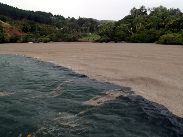 |
Figure 8. Pumice found floating in North Bay along the southern coast of Kadavu, Fiji, on 30 September 2006. Courtesy of Roger Matthews. |
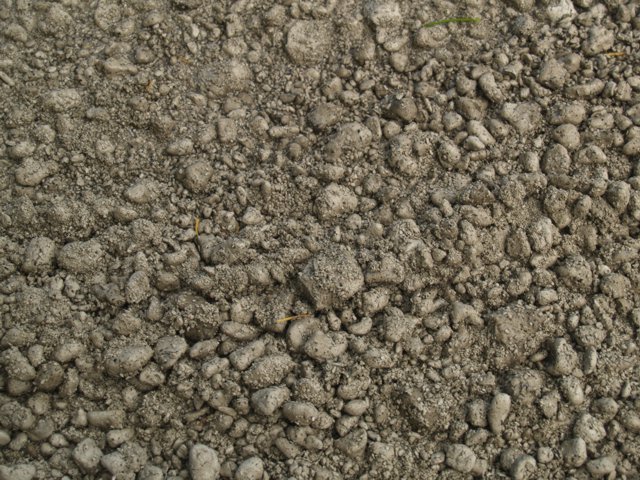 |
Figure 9. A close up view of pumice seen near Matava Resort on the S shore of Kadavu, Fiji, 3 October 2006. Courtesy of Roger Matthews. |
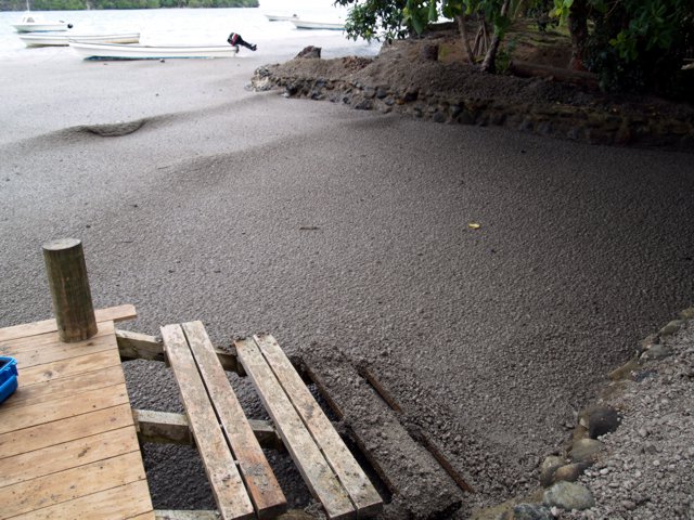 |
Figure 10. Pumice deposits seen at ebb tide near Matava Resort on the S shore of Kadavu, Fiji, 8 October 2006. Some of the pumice has been used as fill behind the sea wall. Deposits can be seen on the steps into the water, and waves propagating through the pumice could still break. Courtesy of Roger Matthews. |
A 31 October story in the Fiji Times described transportation difficulties between Daviqele Village, on the W end of Kadavu, and other parts of the island due to pumice that a resident said had "covered [Naluvea Bay] for over two months now." Similar problems were reported by Adrian Watt at Matava Resort on the S shore of Kadavu. In an email relayed by Roberta Davis, Watt noted that by 2 November the pumice had mostly stopped coming in, with "... just a few strands of small pieces being blown along wind lines here and there." The pieces were generally 5-10 mm in diameter, but several were bigger, and one was larger than 30 cm across. Large bays on Kadavu's SE side were pumice choked, hampering boat travel, and clogged cooling systems damaged or destroyed many outboard engines.
Reference. Thiel, M., and Gutow, L., 2005, The ecology of rafting in the marine environment. II. The rafting organisms and community: Oceanography and Marine Biology: An Annual Review, 2005, v. 43, p. 279-418.
Geological Summary. Home Reef, a submarine volcano midway between Metis Shoal and Late Island in the central Tonga islands, was first reported active in the mid-19th century, when an ephemeral island formed. An eruption in 1984 produced a 12-km-high eruption plume, large amounts of floating pumice, and an ephemeral 500 x 1,500 m island, with cliffs 30-50 m high that enclosed a water-filled crater. In 2006 an island-forming eruption produced widespread dacitic pumice rafts that drifted as far as Australia. Another island was built during a September-October 2022 eruption.
Information Contacts: Fredrik Fransson and Håkan Larsson, Yacht Maiken, 32 Macrossan St., Unit 70, Brisbane 4000, Australia (URL: http://yacht-maiken.blogspot.com/); Paul and Nancy Horst, Encore II (URL: http://www.encorevoyages.com/); KB1LSY Crew (URL: http://www.pangolin.co.nz/yotreps/tracker.php?ident=KB1LSY); Matangi Tonga Online, Vava'u Press Ltd., PO Box 958, Nuku'alofa, Tonga (URL: http://www.matangitonga.to/); Roger Matthews, Private Bag 93500, Takapuna, North Shore City 1332, New Zealand; Ken Tani, R/V Yokosuka; David Forsythe, Naitauba Island, Fiji; David Cothran, 1211 Colestin Rd., Ashland, OR 97520, USA; Bob McDavitt's Weathergram (URL: http://www.pangolin.co.nz/yotreps/list_manager.php##Bob McDavitt's Pacific Weathergrams); Nick Sambrook, Tall Ship Soren Larsen, P.O.Box 60-660 Titirangi Auckland 0642, New Zealand (URL: http://www.sorenlarsen.co.nz/2006/V237_Tonga-Fiji/V237_Tonga-Fiji_Nick.htm, http://www.sorenlarsen.co.nz/Voylog_Track.htm); Windbird Crew (URL: http://handleysail.com/logs/?cat=1&paged=2); NAI'A Liveaboard Scuba Diving, Lautoka, Fiji (URL: http://www.naia.com.fj/); Roberta Davis, Makaira by the Sea, Taveuni, Fiji (URL: http://www.fijibeachfrontatmakaira.com/); Adrian Watt, Matava Resort, Kadavu, Fiji (URL: http://www.matava.com/); Sara Berman and Jean Philippe Chabot (URL: http://zayasail.blogspot.com/2006/09/east.html).