Report on Northern EPR at 9.8°N (Undersea Features) — November 2006
Bulletin of the Global Volcanism Network, vol. 31, no. 11 (November 2006)
Managing Editor: Richard Wunderman.
Northern EPR at 9.8°N (Undersea Features) Lava erupted along at least 18 km of ridge axis
Please cite this report as:
Global Volcanism Program, 2006. Report on Northern EPR at 9.8°N (Undersea Features) (Wunderman, R., ed.). Bulletin of the Global Volcanism Network, 31:11. Smithsonian Institution. https://doi.org/10.5479/si.GVP.BGVN200611-334050
Northern EPR at 9.8°N
Undersea Features
9.83°N, 104.3°W; summit elev. -2500 m
All times are local (unless otherwise noted)
According to the RIDGE 2000 Program website, a new eruption on the East Pacific rise (EPR) was first suspected during a visit to the site by the research vessel RV Knorr in April 2006. Since October 2003 an array of up to 12 ocean-bottom seismometers (OBSs) had been deployed in an area ~ 4 x 4 km located between 9°49' N and 9°51' N (the EPR Integrated Study Site, ISS) as part of a continuing microseismicity monitoring project being led by Maya Tolstoy and Felix Waldhauser.
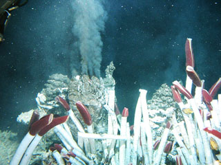
Investigators attempted to recover 12 OBSs on 25 April 2006, but only four were recovered. Tolstoy and others (2006), Chadwick (2006), and the Ridge 2000 Program (2006) reported that eight OBS were stuck in the new lava on the sea floor (see figure 5) from an eruption that had occurred since the last OBS servicing in May 2005. Water column measurements were also made by the RV Knorr, yielding light-scattering measurements indicative of extensive particulates in the water column, and corroborating the evidence for a recent eruption (BGVN 31:06).
 |
Figure 5. Sea floor photo from the TowCam taken on the EPR during the June 2006 RV Atlantis cruise showing an ocean-bottom seismometer caught in a new lava flow. Taken from Chadwick (2006). |
The TowCam images suggested that the new lavas erupted from fissures within the axial summit trough (AST), which reestablished quickly after the event by drain-back and collapse. Comparison of TowCam bathymetry with pre-eruption Alvin mapping suggested that after the eruption the axial summit trough became 10-15 m narrower and a few meters shallower at 9°50.4' N. Lava flow morphologies indicate that the highest effusion rates were near 9°50' N.
Radiometric dating of 10 rocks collected from the young terrain is under way, using 210Po. Preliminary 210Po results in Tolstoy and others (2006) indicate that nine of the rocks were erupted within a year before their collection, with dates ranging from late summer 2005 to January 2006.
According to Tolstoy and others (2006), based on the sea-floor images, the extent of water column anomalies, the preliminary lava ages, and the distribution of OBSs that failed to return, they estimated that the flow extended intermittently for at least 18 km along the ridge axis. This zone extends from 9°46' N to 9°55.7' N, with off-axis extent ranging from 0 to 1 km. The eruption occurred on the same segment (segment B) as the 1991-1992 eruption, with a similar length scale.
The loss of some seismometers did not preclude the capture of important data associated with the eruption, including precursory activity. Tolstoy and others (2006) found a gradual ramp-up in seismicity since monitoring began at this site in October 2003. The pattern of seismicity culminated in an intense but brief (6-hour) inferred diking event on 22 January 2006, followed by rapid tapering to markedly decreased levels of seismicity.
Two follow-up cruises proceeded to the eruption site, the RV New Horizon in April-May 2006, and the RV Atlantis in June 2006. They assessed the extent of the new eruption and its effect on the biological communities, ecosystems, and chemistry at the EPR ISS. More work on the event was recently reported at the Fall 2006 meeting of the American Geophysical Union (Eg., session V13 C).
Background. The East Pacific Rise (EPR) near 9°50' N spreads at a full rate of ~ 110 mm per year and is one of the better-studied mid-ocean ridge (MOR) segments in the world. Ever since an eruption was documented in 1991, scientists have regularly returned to document ecosystem progression, to study changes in vent-fluid chemistry and temperature, and to conduct detailed geological mapping. Anomalies in water-column measurements of temperature and light scattering indicated vigorous discharge of high-temperature hydrothermal fluids. Radiometric dating of rocks collected from the young terrain, using 210Po, indicated that many of the rocks were erupted within a year before their collection. Sea-floor images give further evidence of the recency of surface lava flows.
References. Tolstoy, M., Cowen, J.P., Baker, E.T., Fornari, D.J., Rubin, K.H., Shank, T.M., Waldhauser, F., Bohnenstiehl, D.R., Forsyth, D.W., Holmes, R.C., Love, B., Perfit, M.R., Weekly, R.T., Soule, S.A., and Glazer, B., 2006, A sea-floor spreading event captured by seismometers, Science, v. 314, no. 5807, p. 1920-1922.
Hinds, J.S., Perfit, M.R., Soule, S.A., Fornari, D.J., and Ridley, W.I., 2005, Discriminating lava flows from the EPR ISS (9°25'-9°55' N) using lava morphology, petrography, and geochemistry: American Geophysical Union, Fall Meeting 2005, abstract ##T31A-0496 (2005AGUFM.T31A0496H).
Chadwick, W.W., Jr., 2006, A submarine volcano is caught in the act: Science, v. 314, no. 5807, p. 1887-1888.
Ridge 2000 Program, 2006, News: Ridge 2000 research discover/document seafloor eruption: Ridge 2000 Program web site, URL: http://www.ridge2000.org/science/tcs/epr_2006_science_supp_material.php.
Geological Summary. A series of dives with the submersible Alvin in 1991 on the East Pacific Rise at about 9°50'N detected evidence for a very recent, possibly ongoing, eruption. Hot-vent animal communities documented during November-December 1989 had been buried by fresh basaltic lava flows, and the scorched soft tissues of partially buried biota had not yet attracted bottom scavengers. Fresh black smoker chimneys and new lava flows were present. This site is south of the Clipperton Fracture Zone at a depth of about 2,500 m, and about 1,000 km SW of Acapulco, México; the south end of the Lamont Seamount chain is about 10 km NW. This is also the location where lava flows previously estimated as being less than roughly 50 years old had been found. Later dating using very short half-life radionuclides from dredged samples confirmed the young age of the eruption and indicated that another eruptive event had taken place in late 1991 and early 1992. An eruption in 2005-2006 produced lava flows that entrapped previously emplaced seismometers.
Information Contacts: Ridge 2000 Program, Ridge 2000 Program Office, Institute of Geophysics and Planetology (IGPP), University of California San Diego, Scripps Institution of Oceanography, La Jolla, CA 92093-0225, USA (URL: http://www.ridge2000.org/).