Report on Erebus (Antarctica) — December 2006

Bulletin of the Global Volcanism Network, vol. 31, no. 12 (December 2006)
Managing Editor: Richard Wunderman.
Erebus (Antarctica) Large eruptions stop in June 2006
Please cite this report as:
Global Volcanism Program, 2006. Report on Erebus (Antarctica) (Wunderman, R., ed.). Bulletin of the Global Volcanism Network, 31:12. Smithsonian Institution. https://doi.org/10.5479/si.GVP.BGVN200612-390020
Erebus
Antarctica
77.53°S, 167.17°E; summit elev. 3794 m
All times are local (unless otherwise noted)
The Mt. Erebus Volcano Observatory (MEVO) website contains a graph showing activity measured at the volcano since 1992 (figure 10). The most substantial peaks in the number of eruptions recorded appeared in 1995, 1997, 1998, 2000, and a broad peak beginning in late 2005 that continued into late 2006. It is important to note that the graph reports events of all sizes, including periods of extremely frequent and small (
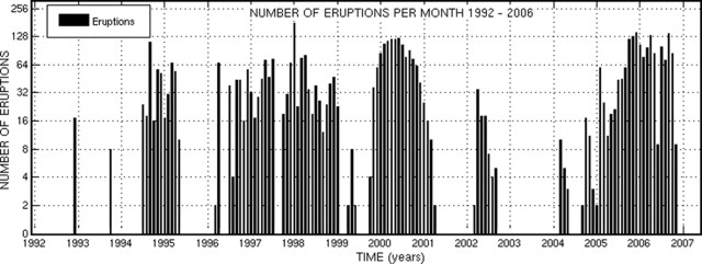 |
Figure 10. Collective vent and lava lake eruptions per month from January 1992 to September 2006 at Erebus (plotted on a vertical log scale). Note that significant incompleteness may exist due to variable reporting criteria and/or instrumentation outages. Quantitative assessment of eruption sizes using infrasonic recordings started in 2006. Courtesy of MEVO web site ("Current Erebus Activity Plot"). |
The older records are based on interpretation of short-period seismographs, and many of the events could have been icequakes (seismic events related to the stick and slip nature of glacial ice movement) and not eruptions. In recent years the use of a video camera, infrasound, and broadband seismic records have allowed better recognition of eruptions. Because of extreme weather, the seismic network is subject to power loss during the darkness of winter.
The MEVO activity log gives information on each eruption measured and shows daily activity that usually includes several eruptions. Erebus eruption sizes are based on the infrasonic overpressure at Station E1S.IS1, measured in pascals (Pa) (see references articles on infrasound measurements). This eruption index scale is divided into small (0-19), medium (20-39), large (40-59), and very large (>=60) events. Although the total number of eruptions remained high during most months of 2006, large or very large events were rarely recorded after 1 June (table 1). The largest event had an index of 116.6 on 26 February.
Table 1. Large and very large eruptions recorded at Erebus, January-November 2006. Data courtesy of MEVO.
| Month | Large Eruptions | Very Large Eruptions |
| Jan 2006 | 22 | 0 |
| Feb 2006 | 18 | 5 |
| Mar 2006 | 13 | 7 |
| Apr 2006 | 11 | 9 |
| May 2006 | 12 | 3 |
| Jun 2006 | 1 | 0 |
| Jul 2006 | 0 | 0 |
| Aug 2006 | 0 | 1 |
| Sep 2006 | 1 | 0 |
| Oct 2006 | 1 | 0 |
| Nov 2006 | 0 | 0 |
General References. Wilson, C.R., J.V. Olson, D.L. Oborne, and A. Le Pichon, 2003 (December), Infrasound from Erebus Volcano at 155US in Antarctica, Inframatics-The Newsletter of Subaudible Sound, no. 04, p.1-8.
Johnson, J.B., and Aster, R.C., 2005, Relative partitioning of acoustic and seismic energy during Strombolian eruptions: Journal of Volcanology and Geothermal Research, v. 148, p. 334-354.
Johnson, J.B., Aster, R.C., and Kyle, P.R., 2004, Volcanic eruptions observed with infrasound: Geophysics Research Letters, v. 31, no. L14604, 4 p.
Johnson, J.B., Aster, R.C., Ruiz, M.C., Malone, S.D., McChesney, P.J., Lee, J.M., and Kyle, P.R., 2003, Interpretation and utility of infrasonic records from erupting volcanoes: Journal of Volcanology and Geothermal Research, v. 121, p. 15-63.
Geological Summary. Mount Erebus, the world's southernmost historically active volcano, overlooks the McMurdo research station on Ross Island. It is the largest of three major volcanoes forming the crudely triangular Ross Island. The summit of the dominantly phonolitic volcano has been modified by one or two generations of caldera formation. A summit plateau at about 3,200 m elevation marks the rim of the youngest caldera, which formed during the late-Pleistocene and within which the modern cone was constructed. An elliptical 500 x 600 m wide, 110-m-deep crater truncates the summit and contains an active lava lake within a 250-m-wide, 100-m-deep inner crater; other lava lakes are sometimes present. The glacier-covered volcano was erupting when first sighted by Captain James Ross in 1841. Continuous lava-lake activity with minor explosions, punctuated by occasional larger Strombolian explosions that eject bombs onto the crater rim, has been documented since 1972, but has probably been occurring for much of the volcano's recent history.
Information Contacts: Philip R. Kyle and Kyle Jones, Mt. Erebus Volcano Observatory, New Mexico Institute of Mining and Technology, Socorro, NM 87801, USA (URL: https://nmtearth.com/); Hawai'i Institute of Geophysics and Planetology (HIGP) MODIS Thermal Alerts, School of Ocean and Earth Science and Technology (SOEST), Univ of Hawai'i, 2525 Correa Road, Honolulu, HI 96822, USA (URL: http://modis.higp.hawaii.edu/).