Report on Ol Doinyo Lengai (Tanzania) — February 2007

Bulletin of the Global Volcanism Network, vol. 32, no. 2 (February 2007)
Managing Editor: Richard Wunderman.
Ol Doinyo Lengai (Tanzania) March-April 2006 eruption sends lava down flanks
Please cite this report as:
Global Volcanism Program, 2007. Report on Ol Doinyo Lengai (Tanzania) (Wunderman, R., ed.). Bulletin of the Global Volcanism Network, 32:2. Smithsonian Institution. https://doi.org/10.5479/si.GVP.BGVN200702-222120
Ol Doinyo Lengai
Tanzania
2.764°S, 35.914°E; summit elev. 2962 m
All times are local (unless otherwise noted)
The previous Bulletin report (BGVN 31:03) discussed an unusually vigorous eruption during late March and early April 2006. This report revisits the March 2006 eruption and continues to the beginning of 2007, thanks in large part to the reports of many observers posted by Frederick Belton on his website.
March-April 2006 eruption. The March 2006 eruption was initially characterized in the Arusha Times as being more massive than the one in 1966. However, Celia Nyamweru noted that subsequent information indicated that the 2006-2007 event was smaller than the 1966-1967 event. During the March-April 2006 event, the volcano was reported to have emitted "red-hot rivers of molten rock and scalding fumes." Ibrahim Ole Sakay, a resident of Ngaresero (-1.3 km from the volcano) reported that the eruption began on the night of 24 March 2006, continuing the following day, and marked by "rumbling and spitting lava for more than a week."
Several news sources, including CNN, reported that on 30 March 2006 the eruption led to the evacuation of up to 3,000 people from several villages, some quite distant from the volcano. As of 5 April, there was a great deal of contradictory information about this eruption. Belton noted that news media and people distant from the volcano reported explosions, but that people living and working nearby reported a "smoke column" followed by a very large lava flow down the W flank, but no explosions or ash. All evidence now indicates that there was no explosive activity and that this was only a very large eruption of lava.
Visitor observations. Belton posted reports from a number of persons who observed the volcano before and shortly after the March 2006 eruption. One observer, Christoph Weber, drew a new map of the crater in February 2006 (figure 91). Belton visited the volcano in August 2006 and provided (figure 92) an update to Weber's February map as well as a photo of the recent changes (figure 93). The following text and table 11 were taken from observations by visitors, as reported by Belton on his website.
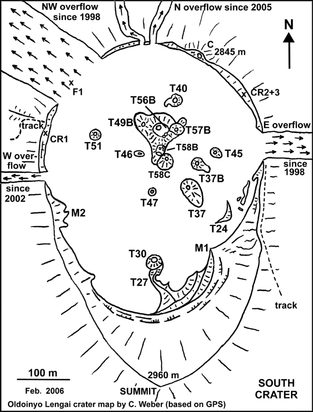 |
Figure 91. Sketch map showing features in Ol Doinyo Lengai's active crater as of February 2006 (i.e., before the March-April 2006 eruption). Courtesy of Christoph Weber. |
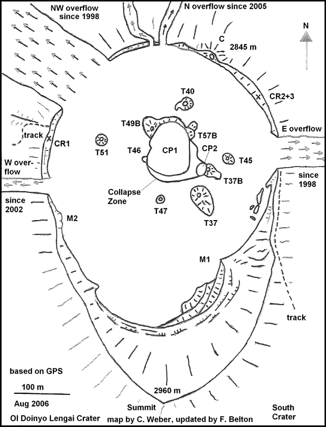 |
Figure 92. Sketch map showing features in Ol Doinyo Lengai's active crater as of August 2006 (i.e., after the March-April 2006 eruption). Courtesy of Frederick Belton, based on update of the map by Christoph Weber. |
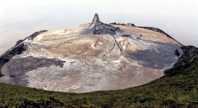 |
Figure 93. Photo of Ol Doinyo Lengai's active crater as seen 7 August 2006, looking N from the S rim. To elucidate recent changes in the crater, see maps in figures 91 and 92 [and earlier maps and photos from BGVN 31:03 (March 2006), 30:10 (October 2005), and 30:04 (April 2005)]. The tall cone is T49B. Slightly to its front and to the right, note the large collapse zone that grew in the spot where cones T56B, T58B, and T58C once stood. The dark lava on the right (E side of crater) was believed to have erupted around 20 June 2006 from T37B. The dark lava to the lower left probably dates from early April 2006. Although it appears dark and fresh here, it had already been highly weathered and easily crumbled into powder if touched. Courtesy of Frederick Belton. |
Table 11. Summary of visitors to Ol Doinyo Lengai and their brief observations (from a climb, crater overflight photos, or from the flank) from January 2006 to February 2007 (see figures 91 and 92 for crater features). Detailed observations prior to March 2006 were reported in BGVN 31:03; most of the later observations were detailed in the text. Courtesy of Frederick Belton.
| Date | Reporting Visitor(s) | Brief Observations |
| 04 Jan-06 Jan 2006 | Bernard Donth | Climb, 1100 hours, 4 Jan: lava from hornito T49B; spatter and little flows in all directions with eruption every 30 minutes; 1 larger flow reached NW Overflow. At 1500 hours activity decreased; no more flows during rest of stay. |
| 10 Jan 2006 | Christian Mann and family | Climb: no activity except some degassing from hornito T47. During previous weeks lava filled large open vent of T56B and flowed from there to possibly other locations onto NE part of crater floor. |
| 02 Feb-07 Feb 2006 | Christoph Weber with film team | Climb: see BGVN 31:03. |
| 13 Feb 2006 | Christoph Weber | Overflight: new lava flows from T58B and T56B vents. Crater rim overflow widths unchanged since Aug 2005. |
| 25 Feb-26 Feb 2006 | Chris DeVries with McGill Univ. students | Climb: see BGVN 31:03. |
| 11 Mar 2006 | Cristine Mentzel | Overflight: numerous small lava flows extending in all directions in the crater from the central cone cluster. |
| 13 Mar 2006 | Rick and Heidi Rosen | Overflight. |
| 14 Mar 2006 | Serge and Sandrine Magnier | Overflight: fresh lava on crater floor. Photos of lava show thin, fine textured aa flows, very black, originating from unidentifiable source in central cone cluster. |
| 29 Mar 2006 | Locals reporting to Amos Bupunga | Flank: lava flowed within 2 km of village, but no one vacated. |
| 01 Apr 2006 | Dean Polley | Overflight: photos of crater documenting partial collapse of T56B and T58B and possible existence of a lava lake there. |
| 01 Apr 2006 | Matt Jones | Climb. |
| 04 Apr 2006 | Michael Dalton-Smith | Overflight. |
| 05 Apr 2006 | Michael Dalton-Smith | Flank. |
| 07 or 08 Apr 2006 | Amos Bupunga | Climb: lava still being emitted only within the new lake. |
| 06 May-11 May 2006 | Jean Perrin | Climb: absence of lava lake activity; a thick ash layer was seen in the crater. |
| 12 May-13 May 2006 | Tobias Fischer | Climb. |
| 21 May-28 May 2006 | Matthieu Kervyn | Climb. |
| 13 Jul-15 Jul 2006 | Steve Beresford, Michelle Carey, Mark and Rene Tait | Climb. |
| 31 Jul-05 Aug 2006 | Daniela Szczepanski, Andreas Ramsler, Norbert Fischer | Climb: no activity other than smoking cones and rockfalls in the collapse zone. |
| 04 Aug-08 Aug 2006 | Fred Belton, Peter and Jennifer Elliston | Climb. |
| 20 Aug 2006 | Ram Weinberger, Majura Songo | Climb: no significant changes in crater since 8 Aug. |
| 22 Aug 2006 | Helene Frume | Climb: no eruptive activity and no visible change since 20 Aug. |
| 22 Sep 2006 | Magda Kozbial | Climb: no activity since the previous reported visit on 20 and 22 Aug; only noticeable change since early Aug was some additional collapse of CP1 on its W edge, which appeared to have destroyed all but a tiny remnant of T46. Smoke arose from the cracks in the ground near the crater (CP1) behind the biggest cone, mostly at the location of T46, and smell of sulfur quite strong. |
| 31 Jan-02 Feb 2007 | Tom Pfeiffer | Climb. |
When Rick and Heidi Rosen flew over on 13 March 2006, there appeared to be no activity and many lava flows had turned white. Several flows still contained dark areas, their surface color indicating that they were then only a few days old. Narrow flows extended in all directions from the central cone mound, and a small flow originating on the upper part of T49B extended across the NW crater rim overflow and a short distance down that flank. Lava also appeared to have reached the E crater rim overflow. Most of the flows appeared to have been subject to the same amount of weathering, except for the flow down the NW flank, which looked more recent.
After a 1 April 2006 climb, Matt Jones reported that there was a fairly large lava flow down the W flank. Residents in nearby Ngaresero village and the Ngorongoro District Commissioner said that activity started on 27 March 2006. At the summit in the dark, Jones noted no glowing from lava emissions. The new eruption left a big hole to the left of the climbing path to the crater that emitted a plume of steam. On the following day, abundant steam came from the hornitos and from fissures all around the rim. Two central hornito's had been blown open relatively recently.
According to people interviewed by Amos Bupunga, who visited later, lava had flowed out on 29 (30?) March 2006 and extended to ~ 2 km from a Maasai family village (boma) at Ol Doinyo Lengai's foot. Bupunga heard that residents did not vacate their village. In the crater, lava of unstated ages covered almost all of the NW to SE regions of the crater to a depth of 2 m. At its outlet over the crater's W rim, one or more lava flows was 2.5 m deep and 3 m wide.
On 4 April 2006, Michael Dalton-Smith flew over and observed a very large lava flow that traveled over 1 km down the mountain and into a gorge. He reported that a bush pilot observed a 30 March eruption consisting of a fountain and lava flow, without an ash cloud. Local pilots also noted that on 4 April the eruption stopped. No steam was seen, nor any evidence that the large lava flow was still hot or moving.
On 5 April, Dalton-Smith drove to the foot of the volcano and saw a huge lava fountain coming from one of the summit hornitos. The fountain stopped before he could photograph it, but from the previous overall structure of the hornitos, it appeared that a new one had been building. All hornitos emitted black plumes, and there appeared to be a lake at the summit about the size of the large hornito.
Amos Bupunga visited the crater on 7 or 8 April 2006, and, in addition to the above-mentioned information he gathered relevant to 29 or 30 March, he saw that the fresh lava coming to the surface remained inside the new lava lake.
Table 12 summarizes annual measurements from 2000 to 2006 of widths of lava flows leaving the crater at various rim overflows. The number and size of the overflows have generally grown, although the width of the NW overflow has remained 135 m since 2002.
Table 12. Annual crater rim overflow measurements taken during 2000 to 2006. Stated values are the width of the crater outflow area at the crater rim. Courtesy of Frederick Belton.
| Date | NW overflow width | E overflow width | W overflow width | N overflow width |
| Jul 2000 | 60 m | 38 m | -- | -- |
| 23 Jul 2001 | 106 m | 38 m | -- | -- |
| 05 Aug 2002 | 135 m | 39 m | 12 m | -- |
| 02 Aug 2003 | 135 m | 44 m | 17 m | -- |
| 16 Jul 2004 | 135 m | 47 m | 17 m | -- |
| 07 Aug 2005 | 135 m | 72 m | 20 m | 1 m at three locations |
| 07 Aug 2006 | 135 m | 73 m | 23 m | 1 m at three locations |
Aerial photos made on 1 April by Dean Polley showed that there had been a huge collapse of the upper parts of hornitos T56B and T58B, which merged together and probably contained a lava lake (figure 94); as noted earlier, photos by Rick Rosen showed that the collapse had not occurred by 13 March 2006.
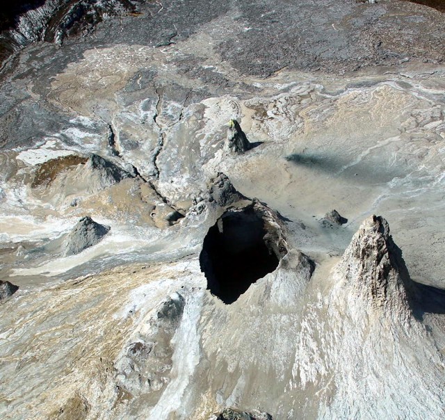 |
Figure 94. Aerial photo of Ol Doinyo Lengai, taken 1 April 2006, viewing the central crater looking toward the S. The very recent collapse of hornitos T56B and T58B, which appear to have merged together, is evidenced by the depressions sharp edges. Courtesy of Dean Polley. |
Polley's 1 April photos show that at the SE base of T58C (just behind the collapse pit) there appeared to be a new vent with prominent lava channels leading away to the SE. Lava from this vent seemingly filled up the low lying areas in the S crater, spilled across the W overflow and down the flank. A similar eruption probably occurred again on 3 April. It was likely that a large amount of the lava was flowing through buried tubes, typical during an eruption of long duration.
From 6-11 May 2006, Jean Perrin and four others from Reunion Island visited ol Doinyo Lengai and reported an absence of active lava flows but small gaseous emissions at some hornitos and plausible rare explosions (which may have also been the sound of rocks collapsing). Due to the very large collapse mentioned above, hornitos T56B, T58B, T58C, and T57B no longer existed. No lava lake activity was seen or heard in the collapsed area. The crater floor was covered with a thick ash layer and looked considerably different than before.
On 12-13 May 2006, Tobias Fischer reported seeing no activity, but the crater was filled with old lava much higher than what was seen the previous year. A very large collapsed cone with sharp rugged edges was noticed in the T58B area. Sulfur dioxide (SO2) flux was measured using a differential optical absorption spectrometer (mini-DOAS), but the fluxes measured were low, the same as in 2005. Sampled lava were later analyzed and their carbonatite compositions were identical to 2005 lavas. Some possible carbonatite tephra was also sampled. Coming from deep inside the volcano there were discrete rumblings lasting for several seconds and up to 10 seconds; these repeated up to 15 times per hour.
Matthieu Kervyn reported that during his visit to the volcano, 21-28 May 2006, he noted no eruptive activity at all except for fumaroles from cracks in the rim and from most of the hornitos (especially in the afternoons). The collapse pit in the middle was enlarging through rim collapse. Visual inspection showed that the collapse pit might soon cause instability of the very high T49B cone. Maasai guides were also expecting T49B to collapse soon. There were some tremors felt several times per hour within the N crater, as if rocks were collapsing beneath the crater.
During 13-15 July 2006, Steve Beresford, Michelle Carey, and Mark and Rene Tait visited the active crater. Activity at that time was limited to abundant fumarolic degassing from the crater rim and central hornitos. They noted a recent (several days old) major lava flow in the SE part of the N crater, its path emanating from the S end of the lava lake at the crater dominating the central N crater. The pre-March 2006 morphology of the N crater had been the scene of a prominent central hornito cluster (figure 91). During 13-15 July the group found much of that cluster destroyed, with the dominant feature on 13 July being a wide (120 x 120 m) crater hosting a recently active lava lake. The hosting crater's S margin was very unstable and periodic collapse of the crater walls was common over the two days of observation. The crater's N margin was marked by a steep collapse scarp in the T49B hornito. Talus breccia from this scarp partially infilled the N part of the lava lake. Numerous scarp collapses (associated with abundant seismic activity) highlighted the ephemeral nature of the current crater/lava lake outline. Marks around the lava lake recorded former high-stands of lava during recent months. SE- and S-draining tubes were present, both testifying to the lateral draining of lava.
The above group saw the S tubes that emanated from the central lava lake appeared to connect to the T37B hornito. The majority of the lava flow of the March-April eruption appeared to have come from this hornito. The reduction in lava lake level and southerly flow direction suggested that the lava lake dramatically drained to the S and may have provided the lava that escaped in the T37B eruption. Pyroclastics surrounding T37B suggested that early mild Strombolian/Hawaiian style activity preceded or accompanied effusion, as was typical of recent N crater volcanism. The lava flow itself was dominantly slabby to spiny pahoehoe with many aa and frothy pahoehoe breakouts along the E margin. This flow appeared similar to an inflated slabby pahoehoe flow field. Very small toothpaste pahoehoe flows emanated from the slabby pahoehoe flow front.
August 2006 map and its interpretation. During 4-8 August 2006, Fred Belton and Peter and Jennifer Elliston camped on the volcano. The visitors found degassing cones and fumaroles; no lava erupted. Occasional rockfalls occurred in the collapse zone.
To explain the August map and field relationships (figure 21), Belton and the visitors provided the following synopsis of the most recent activity and collateral observations. Some of the following revisits observations already discussed, but other points are new to this report and convey the significance of this stage where substantial lava flows descend out of the summit crater.
Prior to their arrival, lava had flowed from T37B and CP2 and spread over the SE part of the crater floor. Thermal anomaly satellite sensing data from MODIS, analyzed by Matthieu Kervyn, indicated that the eruption probably occurred on 20 June (UTC). An Aster image from June 29 shows new dark lava in the SE part of the crater. During the eruption, lava lakes existed in CP1 and CP2 and lava flowed from CP2 and T37B and covered most of the crater floor lying between T45, T37B, T37, and the crater rim. Lava also flowed across the E overflow and down the flank. The flow was composed of at least two distinct, differently weathered lavas that may have occurred within days or hours of one another. The first eruption phase produced a fine-textured aa no more than 40 cm thick and was the more extensive of the two flows, covering a large area of the crater floor and crossing the E rim overflow. The second phase produced a less extensive but much thicker flow, nearly 2 m deep in places, that stopped before reaching the crater rim or the E overflow. It consisted of broken, ropy pahoehoe slabs. Lava from this eruption and possibly from prior activity completely covered cone T24, which was no longer visible. The collapse of the E half of T46 has revealed an interior cave containing long thin stalactites.
Since March 2006, ~ 8,000 m2 of the central crater floor had collapsed. Photographs by several observers indicated that the collapse began just prior to or during the eruption of late March through early April 2006 and continued as an ongoing process. The current collapse zone consisted of two collapse pits, designated CP1 and CP2 in figure 92, plus a fractured area between the two pits and S of CP1 where large sections of terrain had broken away from the crater floor proper and subsided by 1-3 m. The displaced sections had tilted at various angles and were separated from one another and the crater floor by 1- to 2-m-wide fissures. The fissures contain numerous large boulders composed of lavas that were altered by weathering and then lithified.
Cones T58C, T56B, and T58B had collapsed into CP1 and were completely gone. Further enlargement of CP1 claimed the SW half of T57B, the SE base of T49B, and the E half of T46. The SW half of T37B had collapsed into CP2. Tall cone T49B, visible from the Rift Valley floor, appeared likely to collapse in the near future. Failure of its SE base resulted in a talus slope that spilled out onto the floor of CP1. CP1 and CP2 were each ~ 10 m deep with respect to the lowest point on their rims. CP2's floor and E side were talus-covered, but CP1 had a bi-level floor of slabby pahoehoe lava, the surface of a frozen lava lake. A wide lava channel exited CP2 to the SE, near the base of T37B, indicating that it contained a lava lake, which had overflowed onto the crater floor during the March-April eruption. From the lowest point of CP2, a tunnel sloped upward to CP1, connecting the pits. The floor of the tunnel was covered by talus from its unstable walls and roof.
A prominent open lava channel, with a smaller channel diverging from it, led SSE from CP1 past T37 and then wound W and NW to the W overflow, recording the route of the lava that flowed from T58C to Ol Doinyo Lengai's base during the exceptionally strong discharges of roughly 25 March-5 April 2006. Near CP1 the channel's path had thermally eroded to a depth of ~ 3 m, and remained nearly closed at the top. An overhanging ledge contained stalactites. The channel became indistinct in the S part of the crater, but regained prominence near the W overflow, where in places it attained a width of ~ 5 m and depth of ~ 2.5 m. A large chasm just below the W overflow carved by thermal erosion extended ~ 20 m down the flank, with a depth of 5 m and a width of ~ 12 m. Its sides appeared unstable and prone to collapse. Immediately downslope of the chasm, the lava entered an existing gully and could not be easily seen again until the slope moderated near the base of the volcano, at which place the lava chilled only a few meters from the climbing track. From there its path continued into an aa field at its terminus, ~3 km from the summit.
The terminus of the flow lies within 1 km of a Masai boma on the flank, the only habitation evacuated as a result of the eruption. The lava channel near the climbing track was ~ 3 m high and at one point formed a tumulus ~ 5 m in height (tumulus, an elliptical, domed structure formed on the surface of a pahoehoe flow on flat or gentle slopes, created when the upward pressure of slow-moving molten lava within a flow swells or pushes the overlying crust upward). A video of this segment of the lava flow (made during the eruption viewed from the escarpment to the W) showed a rapid, turbulent flow with blobs of lava becoming airborne. The lava near the base of Ol Doinyo Lengai had a dark gray-black coloration and appeared less weathered than might be expected based on its age of 4 months.
Lava flows from the same eruption also covered much of the S part of the crater floor to a depth of at least 2 m. Based on the indistinctness of the main lava channel in the S part of the crater, it appeared likely that the low areas of the S part of the crater were filled by lava prior to spilling over the W crater rim overflow and down the flank. Hornitos T27 and T30, formed in 1993, were completely covered by this flow.
Satellite IR data for 2006 (MODIS and MODLEN). Remote thermal monitoring by satellite using an algorithm called MODLEN was analyzed by Matthieu Kervyn. The analysis suggested an increase in volcanism around 11-13 March 2006. MODLEN is the name of a semi-automated algorithm using MODIS night-time imagery to record thermal activity and detect abnormally high-intensity eruptive events. It is built upon MODVOLC, an algorithm developed by the University of Hawaii, which provides a fully-automated global-coverage hot-spot-detection system. MODLEN was specifically tailored to Ol Doinyo Lengai's low-temperature and small scale eruptive activity (Kervyn and others, 2006a and 2006b).
Table 13 shows the MODIS/MODVOLC thermal anomalies for the year 2006. MODIS thermal alerts on 25, 27, and 29 March 2006 indicated a small but intense area of activity, possibly in the form of a large lava lake. A thermal alert at about 2255 on 29 March was consistent with eye-witness reports and air photos by Polley (mentioned above). A thermal alert for a large area of the flank on 3 April probably indicated a second lava flow to the base of the volcano.
Table 13. MODIS thermal anomalies detected at Ol Doinyo Lengai during 2006. Courtesy of Hawai'i Institute of Geophysics and Planetology.
| Date | Time (UTC) | Number of pixels | Satellite |
| 23 Mar 2006 | 2325 | 1 | Aqua |
| 25 Mar 2006 | 2020 | 5 | Terra |
| 25 Mar 2006 | 2315 | 2 | Aqua |
| 27 Mar 2006 | 2005 | 1 | Terra |
| 27 Mar 2006 | 2300 | 2 | Aqua |
| 29 Mar 2006 | 1955 | 1 | Terra |
| 03 Apr 2006 | 0750 | 2 | Terra |
| 03 Apr 2006 | 2010 | 3 | Terra |
| 03 Apr 2006 | 2310 | 6 | Aqua |
| 04 Apr 2006 | 1130 | 1 | Aqua |
| 20 Jun 2006 | 2025 | 1 | Terra |
| 20 Jun 2006 | 2320 | 1 | Aqua |
Kervyn reported that the MODIS algorithm indicated a strong thermal anomaly in the crater on 20 June 2006 (table 13). He interpreted this anomaly as likely thermal signatures from new lava in the SE part of the crater and the lava lakes that later observers reported. No thermal alerts were detected through the remainder of 2006.
Early 2007 observations. Tom Pfeiffer reported that during a visit from 31 January-2 February 2007, no lava erupted from the summit vents. According to local Masai guides, the form of the central area of the crater with the large collapse pit near the tall hornito T49b appeared unchanged since the summer of 2006. From an open vent in the NE corner at the bottom of the pit at the base of the hornito, continuous sounds of loud sloshing suggested mobile lava in some caverns just beneath that area, an assumption confirmed by the glow of lava visible at night from a second, smaller vent located about 30 m S of the large vent in the base of the collapse pit. One guide confirmed he had seen spattering of lava from this vent some two weeks earlier. In addition to the loud sound of moving lava underground, a constant, deep rumbling could be heard from the ground, resembling the sounds of very distant thundering. It was strongest in the NW area of the crater between the collapse pit and the fissure vents of the March 2006 lava flow.
References. Kervyn, M., Harris, A.J.L., Mbede, E., Jacobs, P., and Ernst, G.G.J., 2006a, MODIS thermal remote sensing monitoring of low-intensity anomalies at volcanoes: Oldoinyo Lengai (Tanzania) and the MODLEN algorithm: Geophysical Research Abstracts, v. 8, p. 03887.
Kervyn, M., Harris, A.J.L., Mbede, E., Jacobs, P., and Ernst, G.G.J., 2006b, MODLEN: A semi-automated algorithm for monitoring small-scale thermal activity at Oldoinyo Lengai Volcano, Tanzania: International Association for Mathematical Geology XIth International Congress, Université de Liège, Belgium, 3-8 September 2006, paper SO9-15.
Geological Summary. The symmetrical Ol Doinyo Lengai is the only volcano known to have erupted carbonatite tephras and lavas in historical time. The prominent stratovolcano, known to the Maasai as "The Mountain of God," rises abruptly above the broad plain south of Lake Natron in the Gregory Rift Valley. The cone-building stage ended about 15,000 years ago and was followed by periodic ejection of natrocarbonatitic and nephelinite tephra during the Holocene. Historical eruptions have consisted of smaller tephra ejections and emission of numerous natrocarbonatitic lava flows on the floor of the summit crater and occasionally down the upper flanks. The depth and morphology of the northern crater have changed dramatically during the course of historical eruptions, ranging from steep crater walls about 200 m deep in the mid-20th century to shallow platforms mostly filling the crater. Long-term lava effusion in the summit crater beginning in 1983 had by the turn of the century mostly filled the northern crater; by late 1998 lava had begun overflowing the crater rim.
Information Contacts: Frederick Belton, Developmental Studies Department, PO Box 16, Middle Tennessee State University, Murfreesboro, TN 37132, USA (URL: http://oldoinyolengai.pbworks.com/); Christoph Weber, Volcano Expeditions International, Muehlweg 11, 74199 Untergruppenbach, Germany (URL: http://www.v-e-i.de/); Celia Nyamweru, Department of Anthropology, St. Lawrence University, Canton, NY 13617, USA (URL: http://blogs.stlawu.edu/lengai/); Matthieu Kervyn, University of Ghent, Geology Department, Ghent, Belgium (URL: http://homepages.vub.ac.be/~makervyn/); Arusha Times, Arusha, Tanzania (URL: http://www.arushatimes.co.tz/); Tom Pfeiffer, Volcano Discovery (URL: http://www.volcanodiscovery.com/); Hawai'i Institute of Geophysics and Planetology (HIGP) Thermal Alerts System, School of Ocean and Earth Science and Technology (SOEST), Univ. of Hawai'i, 2525 Correa Road, Honolulu, HI 96822, USA (URL: http://modis.higp.hawaii.edu/).