Report on Sulu Range (Papua New Guinea) — April 2007
Bulletin of the Global Volcanism Network, vol. 32, no. 4 (April 2007)
Managing Editor: Richard Wunderman.
Sulu Range (Papua New Guinea) Non-eruptive, but geysers and indications of a shallow dike intrusion
Please cite this report as:
Global Volcanism Program, 2007. Report on Sulu Range (Papua New Guinea) (Wunderman, R., ed.). Bulletin of the Global Volcanism Network, 32:4. Smithsonian Institution. https://doi.org/10.5479/si.GVP.BGVN200704-252090
Sulu Range
Papua New Guinea
5.5°S, 150.942°E; summit elev. 610 m
All times are local (unless otherwise noted)
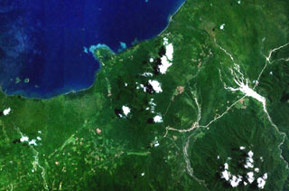
New and revised information has emerged regarding the behavior of the Sulu Range (Johnson, 1971), a volcanic field adjacent to and immediately E of Walo hot springs along the coast in the N-central part of New Britain Island (BGVN 31:07 and 31:09; figure 3). Initial Rabaul Volcanological Observatory (RVO) reports mentioned apparent steam and ash emission during mid-July 2006, but although weak-to-moderate vapor emission occured, and a later section of this report discusses heightened hot spring activity, the reported "forceful dark emissions" have been instead linked to dust during mass wasting.
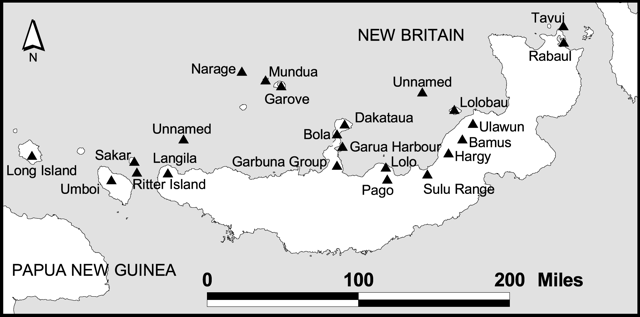 |
Figure 3. A sketch map of New Britain island showing a small portion of the main island of Papua New Guinea (lower left) and New Ireland (upper right). Volcanoes on or adjacent New Britain are labeled. Volcanoes active and erupting frequently in the last decade include (from the SW) Langila, Ulawun, and Rabaul. Volcanoes that have erupted or undergone anomalous unrest in the past few years include (from the SW) Ritter Island, the Garbuna group, Pago, Sulu Range, and Bamus. |
In a 12 April Email message, Steve Saunders clarified the latest RVO views on Sulu's behavior. He noted that ". . . Sulu did not erupt! It was purely a series of seismic cris[es]. The 'emissions' which were reported before we got there turned out to be dust from landslides."
Unusually vigorous hot springs, declining seismicity. Following the first two weeks of unrest during mid-July at Sulu Range, an RVO report discussing 31 July to 2 August activity stated that area hot springs such as those at Walo were undergoing unusually strong activity. This included expelled mud, the emergence of geysers, and abnormal quantities of steam.
RVO noted waning seismicity in late July. Seismicity had declined to relatively low levels, although small volcano-tectonic events continued to be recorded. The small earthquakes were centered around the settlements of Silanga, Sege, and Sale (figure 4; respectively, from Mt.Ruckenberg's summit, located 12.7 km to the SW; 7.2 km SW, and 5.5 km S). The 31 July to 2 August earthquakes were described as more irregular and less frequent than those in preceeding weeks.
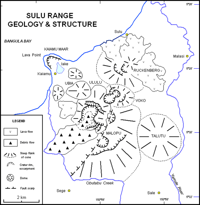 |
Figure 4. Geological map showing the cluster of overlapping cones of the Sulu Range. Walo village lies just off the map near the coast within a few kilometers of the map 's W margin. The thermal area by the same name lies ~ 5 km SW of Lava Point. The prominent cone on the N edge of the Range is called Mount Ruckenberg or Mount Karai. The initial "vent location" was 2 km SW of Mount Karai between Ubia and Ululu volcanoes. Part of that area is crossed by two parallel, closely spaced faults. The narrow zone between those faults was down-thrown. A SW-directed debris flow was also mapped near this area. Three centers in the N, Ruckenberg (Karai), Kaiamu maar, and Voku, are specifically mentioned in the text as areas with recently documented Holocene activity. Modified from a map by Chris McKee, RVO. |
The pattern of located earthquakes defined an irregular ellipse, with major axis 9 km E-W. Two earthquakes represented a 1-2 km extension N from the ellipse under Bangula Bay. There were also two earthquakes offshore about 4-5 km due N of Cape Reilnitz, a broad promontory the most extreme point of which lies 18 km to the W of Mt. Ruckenberg's summit. As of the end of July an area devoid of earthquakes remained; it was 2-3 km in diameter and centered on Walo village.
The RVO estimated that the top of the underlying magma body was 10-15 km deep when volcano-tectonic earthquakes began on 6 July 2006. They judged that volatiles or heat escaping from the magma were responsible for onset of the mud and water ejections at the once quiet hot springs.
Postulated intrusion. Randy White (US Geological Survey) analyzed the July seismic crisis, which in his interpretation did not follow the pattern of a tectonic earthquake with a main shock and associated aftershocks, but did follow behavior of many earthquakes accompanying the onset of volcanic unrest. He attributed the seismicity to a dike intruded to shallow depth (and confined to the subsurface). According to White, the epicenters well outboard of, but surrounding the area of intrusion, occurred in a pattern similar to those accompanying many shallow intrusions.
The elevated seismicity began after a volcano-tectonic earthquake, M ~ 6 on 19 July (BGVN 31:07). It was located on the N side of New Britain, slightly offshore, and a few ten's of kilometers from the Sulu Range. The focal depth was thought to be in the 10-20 km range. White noted that soon after the 19 July earthquake, Australia provided portable seismometers. Once those arrived and began recording data, computed moment tensors indicated that subsequent earthquakes were very shallow. Epicenters occurred slightly W of the Sulu Range.
Short level-lines installed by RVO in August 2006 showed, by November, ~ 2 cm of deflation of the Kaiamu area in relation to a datum ~ 1 km E on the Kaiamu-Sulu track. By April 2006 the measured levels had returned to approximately the August datum line.
To the W of the area at Lasibu a similar pattern existed, with over 2.5 cm of deflation locally measured by November and an approximate return to the datum-line by April 2006. The center of the area delimited by seismicity is swamp and difficult to access. Google satellite images show an interesting series of raised shorelines W of Kaiamu.
Upon prompting from White, Chuck Wicks acquired satellite radar (L-band imagery) from Japanese collaborators for the Sulu Range. The radar data were taken weeks before and weeks after the July seismicity. When processed to obtain radar interferometry, the data indicated over 80 cm of vertical surface deformation. The deformation was centered in a region W of the Sulu Range along an area along the coast ~ 5 km W of Lava Point (Lara Point on some maps). It trends ENE. The data were interpreted as a shallow dike intrusion on the order of ~ 8 m wide trending out beneath Bangula Bay.
Wick's preliminary analysis suggests the intrusion's volume may be on the order of one cubic kilometer. White's qualitative estimate of the volume, from the intensity, style, and duration of the seismicity, were consistent with that analysis. In addition, the strike-slip focal mechanisms seen in the seismic data suggested the dike-intrusion episode caused movement along a nearby strike-slip fault.
Geological investigations conducted in the past several months by Herman Patia and Chris McKee indicated that Sulu Range has been quite active 'recently.' The latest eruptive phase at Kaiamu maar was radiocarbon-dated at 1,300 BP. Since that time at least seven eruptions have taken place at other vents, notably Voko, involving phreatomagmatic eruptions. Ruckenberg (Karai) appears to be the source of the most recent activity. Within the last 200 years it produced lava flows.
Reference. Johnson, RW., 1971, Bamus volcano, Lake Hargay area, and Sulu Range, New Britain: Volcanic geology and petrology: Australia Department of National Development, Bureau of Mineral Resources, Geology and Geophysics, Record 1971/55.
Geological Summary. The Sulu Range consists of a cluster of partially overlapping small stratovolcanoes and lava domes in north-central New Britain off Bangula Bay. The 610-m Mount Malopu at the southern end forms the high point of the basaltic-to-rhyolitic complex. Kaiamu maar forms a peninsula with a small lake extending about 1 km into Bangula Bay at the NW side of the Sulu Range. The Walo hydrothermal area, consisting of solfataras and mud pots, lies on the coastal plain west of the SW base of the Sulu Range. No historical eruptions are known from the Sulu Range, although some of the cones display a relatively undissected morphology. A vigorous new fumarolic vent opened in 2006, preceded by vegetation die-off, seismicity, and dust-producing landslides.
Information Contacts: Steve Saunders, Herman Patia, and Chris McKee, Rabaul Volcanological Observatory (RVO), Department of Mining, Private Mail Bag, Port Moresby Post Office, National Capitol District, Papua New Guinea; USGS Earthquakes Hazard Program (URL: http://earthquakes.usgs.gov/); Randy White and Chuck Wicks, US Geological Survey, 345 Middlefield Rd., MS 977, Menlo Park, CA 94025, USA; United Nations Office for the Coordination of Humanitarian Affairs (URL: https://reliefweb.int/).