Report on Barren Island (India) — July 2007

Bulletin of the Global Volcanism Network, vol. 32, no. 7 (July 2007)
Managing Editor: Richard Wunderman.
Barren Island (India) Aviation reports and thermal hot spots suggest eruptions into September 2007
Please cite this report as:
Global Volcanism Program, 2007. Report on Barren Island (India) (Wunderman, R., ed.). Bulletin of the Global Volcanism Network, 32:7. Smithsonian Institution. https://doi.org/10.5479/si.GVP.BGVN200707-260010
Barren Island
India
12.278°N, 93.858°E; summit elev. 354 m
All times are local (unless otherwise noted)
According to news reports of Indian Coast Guard statements, the eruptive activity that began in late May 2005 (BGVN 30:05) at Barren Island had diminished by late September 2006 (BGVN 31:09). Since then, based upon pilot and satellite data, the Darwin Volcanic Ash Advisory Centre (VAAC) reported multiple ash-and-steam plumes. The plumes reached an altitude of 1.5 km (drifting WNW) on 19 and 20 October 2006, 3 km (drifting SW and W) on 8 November 2006, an unreported altitude and direction on 27 November 2006, 3 km (drifting SW) on 8 February 2007, and 2.1 km (drifting S) on 3 March 2007. The Darwin VAAC had not issued further advisories on Barren Island activity through August 2007.
A compilation of MODIS thermal anomaly data from the Aqua and Terra satellites (figure 13) shows that the eruption began on 26 May 2005 (BGVN 31:01) and has continued through at least 1 September 2007. The level of lava emissions remained high between May 2005 and mid-March 2006. On 17 March 2006 the MODVOLC system identified nine hot pixels in Aqua MODIS data. After that time detectable lava activity decreased and became intermittent, though explosive activity may have been present. More frequent anomalies were detected during April 2006, October-November 2006, and May 2007.
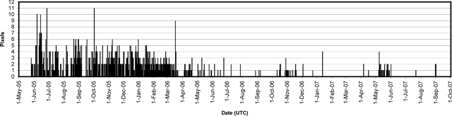 |
Figure 13. Daily thermal anomalies at Barren Island from the MODIS/MODVOLC satellite observations, May 2005 to early September 2007. Vertical scale indicates the daily number of alert pixels detected n a specific thermal image, generally a reflection of the extent of hot lava flows. Anomalies are from both the Aqua and Terra satellites and were accessed for this report in early September 2007. Courtesy of the HIGP MODIS Thermal Alert System. |
Geological Summary. Barren Island, a possession of India in the Andaman Sea about 135 km NE of Port Blair in the Andaman Islands, is the only historically active volcano along the N-S volcanic arc extending between Sumatra and Burma (Myanmar). It is the emergent summit of a volcano that rises from a depth of about 2250 m. The small, uninhabited 3-km-wide island contains a roughly 2-km-wide caldera with walls 250-350 m high. The caldera, which is open to the sea on the west, was created during a major explosive eruption in the late Pleistocene that produced pyroclastic-flow and -surge deposits. Historical eruptions have changed the morphology of the pyroclastic cone in the center of the caldera, and lava flows that fill much of the caldera floor have reached the sea along the western coast.
Information Contacts: HIGP MODIS Thermal Alert System, Hawai'i Institute of Geophysics and Planetology (HIGP), University of Hawaii and Manoa, 168 East-West Road, Post 602, Honolulu, HI 96822, USA (URL: http://modis.higp.hawaii.edu/); Darwin Volcanic Ash Advisory Centre, Bureau of Meteorology, Northern Territory Regional Office, PO Box 40050, Casuarina, Northern Territory 0811, Australia (URL: http://www.bom.gov.au/info/vaac/).