Report on Ol Doinyo Lengai (Tanzania) — November 2007

Bulletin of the Global Volcanism Network, vol. 32, no. 11 (November 2007)
Managing Editor: Richard Wunderman.
Ol Doinyo Lengai (Tanzania) New lava linked to Plinian eruptions of August-September 2007
Please cite this report as:
Global Volcanism Program, 2007. Report on Ol Doinyo Lengai (Tanzania) (Wunderman, R., ed.). Bulletin of the Global Volcanism Network, 32:11. Smithsonian Institution. https://doi.org/10.5479/si.GVP.BGVN200711-222120
Ol Doinyo Lengai
Tanzania
2.764°S, 35.914°E; summit elev. 2962 m
All times are local (unless otherwise noted)
Following explosive eruptions beginning on 1 January 1983, Ol Doinyo Lengai (hereafter called 'Lengai') entered a stage consisting chiefly of the effusion of numerous small fluid, carbonatitic lava flows in its active N summit crater. During March 1983 to early 2007, reports focused almost exclusively on the summit crater, the scene of numerous, often-changing hornitos (or spatter cones) and carbonatitic lava flows that slowly filled the crater. Lava began overflowing the crater, first to the W around 14 June 1993 (BGVN 18:07), then onto the NW flank (beginning in late October 1998, BGVN 24:02), E flank (beginning in early November 1998, BGVN 24:02), W flank (beginning in February 2002, BGVN 27:10), and N flank (beginning in January 2005, BGVN 30:04), making it important to chronicle changes on the flanks. Observations of activity throughout 2007 are summarized in table 14.
Table 14. Summary of visitors to Ol Doinyo Lengai and their brief observations (from a climb, aerial overflight, flank, or satellite) during 2007. Observations for 2006 were reported in BGVN 32:02. Much of this list is courtesy of Frederick Belton; see Belton's website for most of the contributor's contact information.
| Date | Observer | Observation Location | Brief Observations |
| 31 Jan-02 Feb 2007 | Tom Pfeiffer | Climb | See BGVN 32:02. |
| 03 Mar 2007 | Annette Loettrup | Climb | No activity; no significant changes to crater. |
| 04 Mar 2007 | Janet Davis | Aerial | No activity; no significant changes to crater. |
| 24 Mar 2007 | Unnamed | Climb | No activity; no significant changes to crater. |
| 17 Jun-20 Jun 2007 | Rohit Nandedkar, Hannes Mattsson, Barbara Tripoli | Climb | High but variable activity of the inner crater (see text). |
| 22-23 Jul 2007 | Lindsay McHenry | Climb | Activity in inner crater (see text). |
| 03 Aug-05 Aug 2007 | Julie Machault and the group "Aventure et Volcans" | Climb, Aerial | Small lava flows and an open vent cradling lava (see text). |
| 15 Aug-16 Aug 2007 | Gaston Gonnet | Climb | Mild strombolian activity from 3 cones. |
| 23 Aug 2007 | Gwynne Morson | Aerial | |
| 21, 23 Aug 2007 | Christoph Weber | Climb | Active eruption with lava flows (see text). |
| 01 Sep-02 Sep 2007 | Chiara Montaldo | Climb | Eruption (see text). |
| 03 Sep 2007 | Gwynne Morson | Aerial | Newly formed and erupting cinder cone (see text). |
| 04 Sep 2007 | Sian Brown (pilot) | Aerial | Large ash plume above Lengai. |
| 04 Sep 2007 | NASA satellite | Satellite | ASTER image on NASA's Terra Satellite (see text). |
| 06 Sep 2007 | Gwynne Morson | Aerial | -- |
| 10 Sep 2007 | Jens Fissenebert, Sandra Kliegalhoefer | Flank | High ash plume photographed from Lake Natron Camp. |
| 11 Sep-13 Sep 2007 | Leander Ward | Flank | Eruption (see text). |
| 13 Sep 2007 | Gwynne Morson | Aerial | Heavy ash plumes. |
| 19 Sep-21 Sep 2007 | Jelle Schouten, Stan Brouwer | Aerial | Plumes flowing from Lengai. |
| 22-23 Sep 2007 | Roger Mitchell, Barry Dawson | Aerial | Continuous activity (see text). |
| 24 Sep 2007 | Jen Schoemburg | Flank | Continuous activity (see text). |
| 23 Sep-30 Sep 2007 | Roger Mitchell, Barry Dawson | Flank | Continuous activity (see text). |
| 27 Sep 2007 | Jen Schoemburg | Aerial | Continuous activity (see text). |
| 1st week Oct 2007 | Unnamed pilot | Aerial | Ash plumes rising to 3 km above summit. |
| 05 Oct 2007 | Message forwarded from Louise Leakey | Flank | Ash plume to 3 km. |
| 12 Oct 2007 | Colin Church | Flank | Ash falls on W side of Lengai. |
| mid-Oct 2007 | L. Dudley | Aerial | Heavy ash plume blowing to NW. |
| 09 Oct-16 Oct 2007 | Graham Wickenden | Flank | Ash plumes viewed from Lake Natron Camp. |
| 16 Oct 2007 | Leander Ward | Flank camp N of Lengai on lower slopes of Gelai | Lightning in ash clouds. |
| 16 Oct 2007 | Unnamed | Aerial | Ash cone now dominates entire active crater. |
| 19 Oct 2007 | Kathy Moore (pilot) | Aerial | Eruption at 0830, plumes of smoke and ash to altitude above 7.6 km. |
| 21 Oct 2007 | Leander Ward | Flank | Dark and light ash clouds being erupted from the ash cone. |
| 23 Oct 2007 | Gwynne Morson | Aerial | Dark ash clouds; cone (possibly T49B) still exists. |
| 25 Oct 2007 | Benoit Wilhelmi | Aerial | "extremely aggressive" activity. |
| 29 Oct 2007 | Gwynne Morson | Aerial | Pause in eruption. |
| 31 Oct 2007 | Gwynne Morson | Aerial | Dark ash clouds. |
| 04 Nov 2007 | Tim Leach | Flank Lake Natron Camp | Daily ash eruptions, some lava eruptions at night. |
| 07 Nov 2007 | Toulouse VAAC | Satellite | Lengai remained active, but ash not identified on satellite imagery. |
| 10 Nov 2007 | Michael Dalton-Smith | Flank | Activity continues, constant 'smoke' rising 300-600 m above summit, drifting WSW toward Gol Mountains. |
| 11 Nov 2007 | Tim Leach | Flank Lake Natron Camp | Activity seems to have decreased. |
| 21 Nov 2007 | Toulouse VAAC | Satellite | Lengai remained active, but ash not identified on satellite imagery. |
| 27 Nov 2007 | Tim Leach | Flank Lake Natron Camp | Activity "off and on"; heard report of large "lava eruption" about a week ago. |
As this report goes to press, contradictory reports exist concerning impacts of eruptions on the volcano's flanks, with the key question concerning the amount of impact on those flanks by fires, lava flows, ashfall, or conceivably, volcanic bombs large enough to start fires on impact with the ground surface-or perhaps some combination of these and other processes.
Observations during 17-20 June 2007. A report posted on Frederick Belton's Ol Doinyo Lengai website described a visit by Rohit Nandedkar, Hannes B. Mattsson, and Barbara Tripoli during 17-20 June. They observed generally high, but variable, activity of the inner crater. A lot of sulfuric gasses escaped, mainly at fractures in the outer crater, but also from the big hornito on the SW side. Three spatter cones situated on the S and W side of the inner crater discharged spatter that splashed up to 15-20 m high at intervals of 20 minutes, with 30 minute breaks. All three cones were never active at the same time. The group saw three active interconnected lava ponds (mainly on the E side of the inner crater). The molten material was eroding the E side and destabilizing the adjacent cliff. The ponds were always active, but more vigorous activity lasted for intervals of several hours. On 19 June the crust of the inner crater burst near a big, half-collapsed hornito, sending a lava flow E.
Activity on 19 July 2007. On 20 July 2007 the Associated Press (AP) reported that "Lengai was believed to be the source of a series of shallow earthquakes experienced in the region over the past week" according to Alfred Mutua, the Kenyan government spokesman. On 19 July BBC News reported that hundreds of villagers fled their homes on the slopes in response to the above-mentioned seismic swarm, fearing an imminent eruption. A BBC correspondent reported that lava flowing down a flank was causing panic among villagers. The East African Standard indicated that products of the 19 July eruption had entered inhabited areas, stating that " . . . . more than 1,500 people, most of them Maasai families, vacated their homes in Ngaresero, Orbalal and Nayobi villages following the tremors that triggered the volcanic eruption . . . . Villagers are reported to have heard roaring . . . . before the volcano started discharging ash and lava." There were also reports of a damaged school and two injuries, but no deaths. Subsequent inquiries about the incident have cast doubt on these earlier claims.
Volcanologist Gerald Ernst contacted aviators, guides, scientists, and local inhabitants in the region; they had seen no dramatic eruptive events at the mountain during late July 2007. Overall, the compiled comments indicated that the summit crater was intact and eruptions were confined to the summit area. Keith Roberts was reported to have observed that a landslide kicked up a lot of dust, which could have been confused from a distance with ash from a large flank eruption.
Greg Vaughan of the Jet Propulsion Labs subsequently took a preliminary look at some ASTER satellite imagery and concluded that in mid-June through late July the summit crater was likely to have continued to emit lava. The 20 July thermal emissions supported summit lava eruptions but failed to document any lava that had spilled over the crater rim. In addition, no thermal anomalies were measured by MODIS instruments as reported by the Hawai'i Institute of Geophysics and Planetology (HIGP) Thermal Alerts System from 7 July through 22 August (UTC).
Belton's website contained a report by Lindsay McHenry, who had climbed Lengai on 22-23 July 2007. She reported: "There were frequent minor earthquakes in the days preceding the climb. There were two active spatter cones, one on the far eastern side of the crater and a small one just to the east of the central spire. Both were throwing small blocks ? locally, and occasionally raining ash over the entire crater. Our guides directed us to an aa flow on the northern side of the crater that they claimed was only 4 days old. The interior was still warm and showed no signs of alteration. The flow was confined to the crater."
MODIS (MODVOLC) measurements. Data from MODIS satellites and analyzed with the MODVOLC algorithm revealed no thermal anomalies for the period 7 July-22 August 2007. Instead, multiple thermal anomalies were measured at and around the crater particularly during 23 August-3 September and 10-20 September 2007 (table 15). It is plausible that a brief ash-bearing eruption like the alleged 19 July event could have been missed by the MODIS satellites or not detected by the MODVOLC algorithm.
Table 15. MODIS/MODVOLC thermal anomalies measured at Ol Doinyo Lengai during 2007. No anomalies were detected during 1 January-1 June, 7 July-22 August, 21 September-16 October, 18-30 October, and 1 November-29 December 2007. Anomalies measured by MODIS during 2006 were reported in BGVN 32:02. Courtesy of the Hawai'i Institute of Geophysics and Planetology (HIGP) Thermal Alerts System.
| Date | Time (UTC) | Number of pixels | Satellite |
| 02 Jun 2007 | 0745 | 1 | Terra |
| 23 Jun 2007 | 2025 | 3 | Terra |
| 23 Jun 2007 | 2320 | 1 | Aqua |
| 25 Jun 2007 | 2015 | 1 | Terra |
| 29 Jun 2007 | 1950 | 1 | Terra |
| 29 Jun 2007 | 2245 | 1 | Aqua |
| 30 Jun 2007 | 2030 | 1 | Terra |
| 30 Jun 2007 | 2330 | 1 | Aqua |
| 02 Jul 2007 | 2315 | 1 | Aqua |
| 06 Jul 2007 | 1955 | 1 | Terra |
| 06 Jul 2007 | 2250 | 1 | Aqua |
| 23 Aug 2007 | 1955 | 1 | Terra |
| 23 Aug 2007 | 2250 | 1 | Aqua |
| 25 Aug 2007 | 1940 | 2 | Terra |
| 26 Aug 2007 | 2320 | 1 | Aqua |
| 28 Aug 2007 | 2310 | 1 | Aqua |
| 30 Aug 2007 | 2000 | 2 | Terra |
| 30 Aug 2007 | 2300 | 1 | Aqua |
| 31 Aug 2007 | 0825 | 2 | Terra |
| 31 Aug 2007 | 1120 | 2 | Aqua |
| 31 Aug 2007 | 2045 | 2 | Terra |
| 31 Aug 2007 | 2340 | 2 | Aqua |
| 01 Sep 2007 | 1950 | 10 | Terra |
| 01 Sep 2007 | 2245 | 2 | Aqua |
| 02 Sep 2007 | 0810 | 2 | Terra |
| 02 Sep 2007 | 1105 | 2 | Aqua |
| 03 Sep 2007 | 1935 | 2 | Terra |
| 10 Sep 2007 | 1940 | 1 | Terra |
| 10 Sep 2007 | 2240 | 2 | Aqua |
| 19 Sep 2007 | 2235 | 1 | Aqua |
| 20 Sep 2007 | 0800 | 4 | Terra |
| 17 Oct 2007 | 2000 | 2 | Terra |
| 31 Oct 2007 | 2310 | 1 | Aqua |
| 30 Dec 2007 | 0815 | 1 | Terra |
Observations during early August 2007. The European Association of Volcanologists (LAVE), a group that visits many volcanoes and publishes an informative and colorful newsletter, ascended and camped in the active crater on 3-5 August 2007 (Machault, 2008). Machault (2008) discussed a crater still strewn with multiple hornitos. Many of their observations concerned the emissions at these hornitos and abundant still fresh lava flows of small volume seen spreading over the crater floor. They departed the crater at 0700 on 5 August at which point they saw no activity.
In more detail, one vent at a hornito was particularly active on 3-4 August. The active vent was open and cradling molten lava. It was located well up on the cone of a hornito to the near E of T49B. This vent emitted lapilli on 4 August and the next day it emitted lava. On 4 August the same vent E of T49B discharged a lava flow on the crater floor, 100 m long with several arms. The afternoon of 4 August the same vent issued black "smoke" and clouds. A 'black geyser' rose above the hornitos in the center of the crater but the exact source vent was uncertain.
Eruptions of late August and September 2007. Matthieu Kervyn analyzed MODIS data with the MODLEN algorithm (tailored to the lower temperature lavas at Lengai) and recorded multiple and repeated thermal anomalies at and around the crater after 21 August 2007. This indicated a new eruptive event during 21-23 August, with a peak on 23 August (MODVOLC data in table 15 show anomalies starting 23 August). Anomalies at that time seemed to be restricted to the crater, but moved out to the flanks on 31 August and 1 September. On 23 August, pilot Gwynne Morson photographed the recent lava flows (figure 95), which, when freshly cooled are black in color (later altering to white due to weathering).
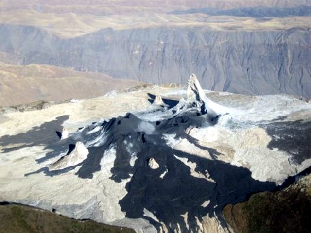 |
Figure 95. Photo showing the Ol Doinyo Lengai crater with recent lava flows (black) on the morning of 23 August 2007. Note the lava overflow (possibly the E overflow) of the crater's rim in the foreground. Courtesy of Gwynne Morson. |
Ashley Davies reported that thermal emissions were detected on 27 August 2007 from the NASA Earth Observing-1 (EO-1) spacecraft, which combined both the Hyperion hyperspectral imager and the ALI multispectral imager, yielding coverage of both visible and short-wavelength infrared (SWIR). Hyperion data (30 m/pixel resolution) showed two very bright sources in the summit crater with spectra consistent with erupting lava. There was also an indication of a short lava flow to the NW. Based on a preliminary analysis of the Hyperion data, effusion rate was estimated at ~ 0.5 m3/s. [Note: As part of the JPL Volcano Sensor Web, the EO-1 observation was triggered autonomously by an alert from the MODVOLC system. This in turn triggered a series of data transmissions and rapid processing at JPL. Notification was received at JPL within 2 hours of data acquisition. JPL processed the Hyperion data within 36 hours of acquisition.]
Chiara Montaldo and her husband climbed Lengai on the night of 1-2 September. Lava started to come out of the crater on the afternoon of 1 September and flowed down the flank all night (figure 96). At 0500 on 2 September, the crater was erupting; the noise and smell was very strong. From time to time there was an explosion sound (like fireworks) and a column of ash and lapilli could be seen. The column was not continuous, and it was incandescent with black smoke and ash. They felt very strong earthquakes on the top. A few hours after they climbed down on 2 September, the column and the noise were higher and the wind changed direction, blowing the ash toward them. On the following night (2-3 September) another group tried to climb the volcano, but retreated about halfway up because the eruption was getting more intense.
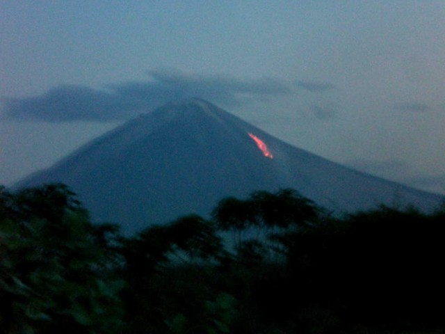 |
Figure 96. Incandescence on the W flank of Ol Doinyo Lengai sometime during 1-3 September 2007. Courtesy of Chiara Montaldo. |
According to Burra Gadiye, a mountain guide, an ash eruption began during the night of 3-4 September 2007. On 3 September pilot Gywnne Morson observed a new erupting cone in the central to E side of the crater. Thomas Holden relayed a pilot's account of a large ash plume on 4 September. The ash plume and strong thermal activity in the crater and probably lava flows to the W and NW may have spawned fires that burned large areas of the W and NW flank, as can be seen in a 4 September 2007 ASTER image (figure 97). Kervyn observed that the volcano erupted on 4 September, first at midnight and then at 0500, causing significant ash clouds. Ash fallout was observed at Engare Sero village, 18 km N of the summit. Ashfall lasted for over 12 hours. The ash cloud was imaged by ASTER on the morning of 4 September drifting SSW. Roger Mitchell attributed the large burned areas on figure 97 as due to fires ignited after the ash eruption of 3-4 September.
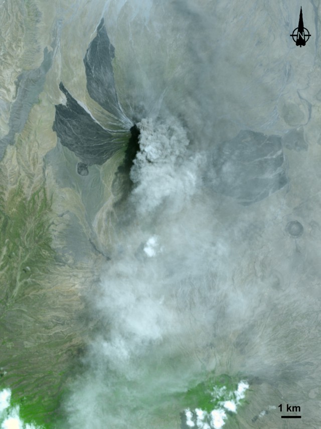 |
Figure 97. ASTER image of Ol Doinyo Lengai taken 4 September 2007 at 0422 UTC (0722 local time) showing a plume of ash and steam blowing S. This eruption sent ash downwind at least 18 km. The large dark lobes on the NW, W, and E flanks extend to inhabited areas. The lobes are not lava flows, but areas burned by fire. The gray volcanic plume appears distinct near the summit, and more diffuse to the S. Image created by Jesse Allen, using data provided courtesy of National Aeronautics and Space Administration/Goddard Space Flight Center/Japan's Ministry of Economy, Trade, and Industry/Japan's Earth Remote Sensing Data Analysis Center/Japan Resources Observation System Organization (NASA/GSFC/METI/ERSDAC/ JAROS) and the U.S./Japan ASTER Science Team. |
Chris Weber reported that during the night of 3-4 September, lapilli- and ash-bearing eruptions rose about 3 km above the vent. Pictures taken from a plane on 5 September indicated that the hornitos and other crater morphology remained without dramatic change. Satellite images around this time showed vast areas of burned vegetation on the S, W, and NW slopes. The charred area at the S was caused by a bush fire that started before 20 August (observed by Weber), while he attributed such areas to the W and NW as caused by lava flows. A sketch of the inner crater was drawn on 23 August by Weber (figure 98).
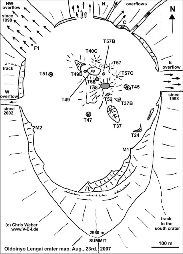 |
Figure 98. Sketch map of the crater of Ol Doinyo Lengai as of 23 August 2007. Note lava overflows and trail to S crater. Courtesy of Chris Weber. |
At about 1100 on 24 September, Jen Schoemburg reported seeing ash rising to an altitude of ~ 4 km, drifting NW. A local safari vehicle driver said that there had often been a 'mirage' visible above the volcano (from gases), but that for the previous two weeks or so the volcano had been emitting ash. He also said that people in surrounding villages had reported skin rashes on themselves and their animals. Additionally, 2-3 weeks prior, there had been earthquakes felt in the region. Near noon on 27 September, Schoemburg flew over going N, with the volcano passing on the W side of the plane (figure 99). The pilot said that in recent weeks ash rose to 6 km altitude; during the fly-over, it was rising to about 4.6 km, still drifting NW.
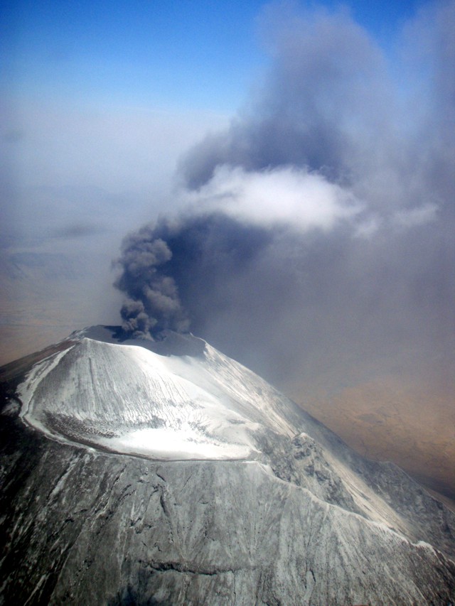 |
Figure 99. Aerial photo of Ol Doinyo Lengai looking W on 27 September 2007. S crater is shown in the foreground. Courtesy of Jen Schoemburg. |
Observations during late September and ash petrology. Barry Dawson and Roger Mitchell reported on activity during 22-30 September 2007 and their petrologic investigations. During an overflight on 22 September, Dawson observed that there had been a complete collapse of the area around former T49 hornito/ash cone area, with the formation of an ash pit surrounded by new black ejecta. A large hornito (T40) between the pit and the N wall of the crater was still in existence. Small emissions of ash, probably less than 100 m high, were drifting N. There was much new whitened ash around the whole summit area, but with most to the S where the S crater and the higher parts of the S slopes were most thickly blanketed, possibly from the plume recorded on the ASTER image (figure 97) of 4 September 2007.
As observed from the foot of the volcano on 23 September and on the early morning of 24 September, there were small, intermittent ash eruptions. At about 0900 on 24 September a strong eruption started, giving rise to a black eruption column that quickly built up to a height estimated to be ~ 6 km (figure 100), where it spread out into a typical Plinian-type cloud. From the lower W slopes, explosions were distinctly heard. This strong eruptive phase lasted till around 1300 with the ash cloud drifting NW and lapilli falling on the NW slopes; lapilli were gathered for a comparative study with lapilli from the 1966 eruption (Dawson and others, 1992). Smaller, intermittent lapilli-bearing eruptions continued until nightfall (around 1830).
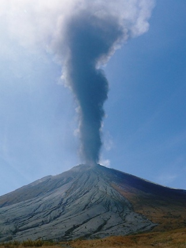 |
Figure 100. Eruption of Ol Doinyo Lengai at 1100 on 24 September 2007, viewed from the lower W slopes. Courtesy of Barry Dawson. |
On 25 September there was minor activity until about 1300, when new eruptions ejected white material. A lapilli cone could be seen from the lower S slopes, and subsequently fountaining took place from two distinct centers within the crater. Activity continued for about four hours. On 26 September there was only minor activity with fine ash drifting to the NW, but in the late afternoon an ash column with a whitened head rose ~ 3 km. In the evening, the atmospheric dust resulted in the sun having a halo, being red in color. The moon that night also had a halo.
On 27 September, the volcano was quiet, but at 0900 on 28 September it erupted again, though no plume developed. There was fountaining from three centers over the next hour, with regular migration of the fountains from N to S; black lapilli was ejected to ~ 200 m above the vent. Activity recommenced at 1330 and lasted all afternoon, with an eruption column up to 2 km high. After this event, the prominent hornito near the N rim of the crater that was previously visible from the lower slopes was no longer visible.
There was no sign of activity on 29 September until 1200, when large eruptions sent material up to 3 km above the volcano. Initially black, the billowing top of the eruption column became white at and above the level of the surrounding atmospheric clouds. This could be interpreted as due to either (1) a higher albedo of finer material at the top of the eruption column, (2) dust forming nucleation sites for condensing atmospheric water, or (3) a combination of the two. In the late afternoon and early evening, dark material from the eruption plume, now much reduced in height, continued to spill down the NW slopes rather like a density flow. On 30 September, when last observed by Dawson, there were only minor ash eruptions that drifted NW.
Dawson noted that up to 30 September, the volume of material erupted and the height of the eruption column appeared smaller than the last major phase of ash eruptions in 1966-67, when plume heights of ~ 10,000 m were estimated, and ash distribution was as far as Seronera (130 km to the W) and Loliondo (72 km to the NW) (Dawson and others, 1968). For comparison, on 27 September 2007 when Dawson visited Sale (a Wasonjo settlement 45 km NW of Lengai), there were no signs of ashfall; during the July 1967 eruption, there was ashfall at Arusha (110 km SE) and at Wilson airfield, Nairobi (190 km NE) (Dawson and others, 1995). Natrocarbonatite lava in the gully immediately S of the climbing track (the overflow from the crater extruded roughly 25 March-5 April 2006, BGVN 32:02) was of two types; (a) a pahoehoe flow containing entrained blocks of wollastonite nephelinite, that was overlain and mainly buried beneath (b) a later aa flow that extended 3 km from the crater. On the upper SE slopes, ~ 200-300 m below the rim of the S crater, there had been extrusion of a short, thin, then-whitened natrocarbonatite flow; flank eruptions are unusual at Lengai.
Mitchell and Dawson collected ash samples on 24 September and subsequently described them as follows. "The lapilli contain nuclei of nepheline, clinopyroxene, Ti-melanite and wollastonite, collectively wollastonite ijolite, probably xenocrystic. Wollastonite and clinopyroxene are replaced by combeite. However the mantling ash consists of nepheline, melilite, combeite (Na2Ca2Si3O9), a Na-Ca carbonate-phosphate, Mn magnetite, and a K-Fe sulphide in a volumetrically-insignificant (less than 5%) sodium carbonate matrix. In lacking clinopyroxene the mantling ash is not nephelinite or melilitite, and is unlike any other magma type previously recorded from the volcano. The mantling ash is interpreted as a hybrid magma formed when nephelinite interacted with natrocarbonatite magma, forming combeite and melilite at the expense of clinopyroxene. The resulting decarbonation reaction released the CO2 that drove the eruption." Mitchell added that the ash seemed to be an extreme variant of the 1996 ash.
Activity during October-November 2007. On his website, Belton reported that Leander Ward saw lightning in some of the ash clouds in the early morning of 16 October 2007. Ward observed that the ash cone then dominated the entire active crater and appeared to have grown significantly in diameter; no other cones were visible. Charter pilot Kathy Moore reported an eruption on 19 October around 0830, sending plumes of smoke and ash into the atmosphere to an altitude of ~ 7.6 km. The plume was visible for ~ 160 km, but the eruption (one large blast followed by a smaller one) lasted only for a few minutes. Within half an hour the large cloud of ash had dispersed and only smaller clouds remained close to the mountain.
Tim Leach, owner of Lake Natron Camp on the S shore of Lake Natron, reported on 4 November that the ash eruption continued on a daily basis. His crew had occasionally seen night-time "lava eruptions." Leach advised against climbing the active crater and stated that they were working on developing safer routes terminating in the inactive S Crater. One difficult route that has been climbed twice from the Kerimasi side was vegetated in September, but by the end of October it was ash covered.
Michael Dalton-Smith reported that as of 10 November activity continued. From a distance he saw constant "smoke" rising 300-600 m above the summit. At one point it appeared that a light colored but strong ash cloud formed a column, but it was difficult to tell for sure due to clouds. Jean-Claude Tanguy sent an aerial photograph (figure 101) taken by Maxime Le Goff on 23 November 2007 that showed pronounced changes in the active crater. A large crater had clearly developed in the center of the N crater and the complex array of hornitos nearly all buried in ash were not in evidence.
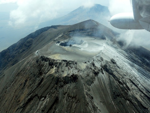 |
Figure 101. Aerial photograph of Ol Doinyo Lengai looking S toward the volcano's summit. A new crater sits amid the tephra-mantled N crater. Gone are the array of hornitos present for years. Taken 23 November 2007 by Maxime Le Goff. Provided by Jean-Claude Tanguy. |
References. Dawson, J. B., Bowden, P., and Clark, G. C., 1968, Activity of the carbonatite volcano Oldoinyo Lengai, 1966, International Journal of Earth Sciences (Geologische Rundshau), v. 57, no. 3, p. 865-879.
Dawson, J. B., Smith, J. V., and Steele, I. M., 1992, 1966 ash eruption of t he carbonatite volcano Oldoinyo Lengai: mineralogy of lapilli and mixing of silicate and carbonate magmas, Mineralogical Magazine, v. 56, p. 1-16.
Dawson, J. B., Keller, J., and Nyamweru, C., 1995, Historic and recent eruptive activity of Oldoinyo Lengai, p. 4-22 in Bell, K., and Keller, J. (eds), Carbonatite Volcanism, Oldoinyo Lengai and the Petrogenesis of Natrocarbonatites, Springer-Verlag, Berlin, p. 4-22.
Machault, J., 2007, Lengai du 3 au 5 ao?t 2007, LAVE, Revue de L'Association Volcanologique Européene, no. 129, p. 29-32, November 2007, 7 rue de la Guadeloupe, 75018 Paris, France (http://www.lave-volcans.com) ISSN 0982-9601.
Geological Summary. The symmetrical Ol Doinyo Lengai is the only volcano known to have erupted carbonatite tephras and lavas in historical time. The prominent stratovolcano, known to the Maasai as "The Mountain of God," rises abruptly above the broad plain south of Lake Natron in the Gregory Rift Valley. The cone-building stage ended about 15,000 years ago and was followed by periodic ejection of natrocarbonatitic and nephelinite tephra during the Holocene. Historical eruptions have consisted of smaller tephra ejections and emission of numerous natrocarbonatitic lava flows on the floor of the summit crater and occasionally down the upper flanks. The depth and morphology of the northern crater have changed dramatically during the course of historical eruptions, ranging from steep crater walls about 200 m deep in the mid-20th century to shallow platforms mostly filling the crater. Long-term lava effusion in the summit crater beginning in 1983 had by the turn of the century mostly filled the northern crater; by late 1998 lava had begun overflowing the crater rim.
Information Contacts: Gerald Ernst, Centre for Environmental & Geophysical Flows, Department of Earth Sciences, University of Bristol, Wills Memorial Building, Queens Road, Bristol BS8 1RJ, United Kingdom; Greg Vaughan, Jet Propulsion Laboratory, Mail Stop 183-501, 4800 Oak. Grove Dr., Pasadena, CA 91109, USA; Frederick Belton, Developmental Studies Department, PO Box 16, Middle Tennessee State University, Murfreesboro, TN 37132, USA (URL: http://oldoinyolengai.pbworks.com/); Hawai'i Institute of Geophysics and Planetology (HIGP) Thermal Alerts System, School of Ocean and Earth Science and Technology (SOEST), Univ. of Hawai'i, 2525 Correa Road, Honolulu, HI 96822, USA (URL: http://modis.higp.hawaii.edu/); Matthieu Kervyn, University of Ghent, Geology Department, Ghent, Belgium (URL: http://homepages.vub.ac.be/~makervyn/); Ashley Davies, NMP-ST6 Autonomous Sciencecraft Experiment Asteroids, Comets and Satellites Group (3224), ms 183-501, Jet Propulsion Laboratory, 4800 Oak Grove Dr., Pasadena, CA 91109-8099, USA; Christoph Weber, Volcano Expeditions International, Muehlweg 11, 74199 Untergruppenbach, Germany (URL: http://www.v-e-i.de/); J. Barry Dawson, Grant Institute of Earth Science, University of Edinburgh, King's Building, Edinburgh EH9 3JW, United Kingdom; Roger Mitchell, Lakehead University, 955 Oliver Road, Thunder Bay, ON P7B 5EI, Canada; Jennifer Fela Schoemburg, Cologne, Germany; Lake Natron Camp, Tim Leach (URL: http://www.ngare-sero-lodge.com/Natron_camp.htm); Kathy Moore; Celia Nyamweru, Department of Anthropology, St. Lawrence University, Canton, NY 13617, USA (URL: http://blogs.stlawu.edu/lengai/); Michael Dalton-Smith (URL: http://digitalcrossing.ca/); Jean-Claude Tanguy, Centre National de la Recherche Scientifique-Institut de Physique du Globe (CNRS-IPGP), Observatoire de Saint-Maur, 4, avenue de Neptune, 94107 Saint-Maur des Fossés Cedex, France; Julie Machault, LAVE "Aventure et Volcans" (sponsored by L'Association Volcanologique Européene, 7 rue de la Guadeloupe, 75018 Paris, France (URL: http://www.lave-volcans.com); USGS National Earthquake Information Center (URL: http://earthquakes.usgs.gov/).