Report on El Chichon (Mexico) — December 2007
Bulletin of the Global Volcanism Network, vol. 32, no. 12 (December 2007)
Managing Editor: Richard Wunderman.
El Chichon (Mexico) Stable with tremor; hot spring; significant crater-lake-volume variations
Please cite this report as:
Global Volcanism Program, 2007. Report on El Chichon (Mexico) (Wunderman, R., ed.). Bulletin of the Global Volcanism Network, 32:12. Smithsonian Institution. https://doi.org/10.5479/si.GVP.BGVN200712-341120
El Chichon
Mexico
17.3602°N, 93.2297°W; summit elev. 1150 m
All times are local (unless otherwise noted)
On 4 November 2007, at midnight, a landslide along the Grijalva river buried a settlement (Juan de Grijalva, Municipio de Ostuacán, Chiapas) located ~ 25 km WSW from the 1982 crater. The event, the subject of a report in the newspaper La Jornada, was reported to have buried 40-60 dwellings and killed at least 10, but more likely 200-300 residents.
Concern arose as to whether the event was triggered by El Chichón volcano. The scientists authoring this report, which included those from the Instituto de Geofísica of the Universidad Nacional Autónoma de México (UNAM), noted that low-frequency rumbling (presumably tremor) can clearly be felt inside the active crater. They associated these perturbations with the hydrothermal system.
The authors considered the perturbations too small to cause the distant landslide. According to the authors, the landslide at the Grijalva river was probably the result of morphological instability after heavy rainfall, rather than associated with El Chichón behavior.
However, in the aftermath of the 1982 eruption, El Chichón's nearby flanks still contain abundant unstable slopes, and the new vegetation fails to keep up with the erosion rate. Also, intracrater avalanches still occur, particularly after heavy rainfall. According to co-author Dmitri Rouwet, the rumbling beneath the crater often triggers small intracrater avalanches.
El Chichón was the scene of large Plinian eruptions in 1982, and the crater hosts a shallow crater lake that has drastically varied in size since January 2001. Figure 8 shows the lake in 2005, the smallest volume at this crater lake yet observed. In March 2007 (figure 9) the lake contained the largest volume yet observed (~ 6 x 10⁵ m3).
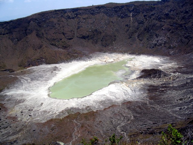 |
Figure 8. The crater lake at El Chichón when it contained the smallest water volume ever recorded here (5 June 2005). The crater diameter is ~ 1 km. Courtesy of L. Rosales. |
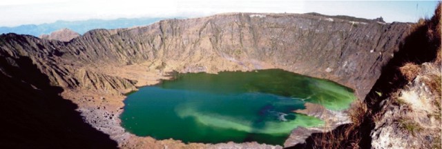 |
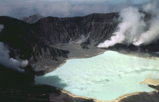
Figure 9. The crater lake at El Chichón when it contained the largest water volume ever recorded here (26 March 2007). Courtesy M. Jutzeler. |
Boiling springs.The changes in lake volume stem largely from variable discharges at a boiling spring, rather than merely reflecting direct input from rainfall and evaporation.
During 2001, 2004 and 2007 a large-volume lake was associated with a high discharge (over 10 kg/s) into the lake. Saline, near-neutral pH water pours from a boiling geyser-like spring on the lake's N coast. This took place in months such as January, only a few months after the end of the June-October rainy season. The salinity was greater when the lake had higher volume. This observation implies that the direct input of rainwater is not a major contributor to lake volume. Instead, rainwater is thought to infiltrate into the crater floor and then discharge into the lake through the boiling springs.
These springs alternate between periods of high- and low-water discharge feeding the lake. The periods of high discharge at the springs correspond to periods when the lake grows. The periods of low discharge at the springs correspond to vapor discharge there, intervals when the lake shrinks.
In general, ongoing measurements suggest decreasing concentrations for the boiling spring and crater lake waters with time. This suggest an absence of new magmatic input since 1982. After the 2007 rainy season the lake volume decreased, coinciding with a change to pure vapor emission from the geyser-like spring since August 2007 (figure 10).
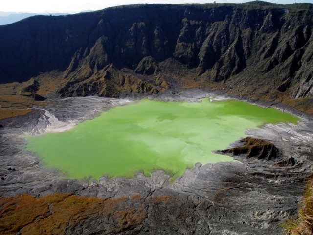 |
Figure 10. The crater lake at El Chichón crater lake as seen on 20 December 2007. Courtesy A. Mazot. |
Tremor, gas fluxes, inferences, and ongoing monitoring.The authors of this report inferred that the low-frequency tremor and rumbling beneath the crater floor stemmed from fluid migrations inside the boiling aquifer, sometimes causing small intra-aquifer phreatic explosions. Nevertheless, crater floor inspection during December 2007 found it unbroken (without evidence of rupture or breaching). The crater morphology, notably the distribution of fumarolic fields, has on the whole remained stable since shortly after the 1982 eruptions.
The CO2 gas fluxes from the crater lake's surface and floor were recently sampled using a floating accumulation chamber to measure the output. The calculated mean emission rate at the lake's surface in March 2007 was 1,500 g/(m2/day), and in December 2007 a preliminary estimate was 860 g/(m2/day). A preliminary flux rate from the crater floor in October 2007 was 1,930 g/(m2/day).
In addition, infrared camera images proved useful to quantify the thermal output. A good correlation appeared between gas flux and ground temperature. This may offer potential for future monitoring.
The authors inferred that future El Chichón volcanism might take the form of intracrater dome growth. Such growth could follow changes in chemistry, temperature and dynamics of the crater lake, the degassing regime, seismicity, geomagnetism, crater morphology, or other unrest such as the onset of phreatic explosions. Such processes can occur very rapidly, as recently shown by the dome growth at Kelud, Indonesia, in November 2007. However, the authors' investigation found no evidence to support current dome growth.
Geological Summary. El Chichón is a small trachyandesitic tuff cone and lava dome complex in an isolated part of the Chiapas region in SE México. Prior to 1982, this relatively unknown volcano was heavily forested and of no greater height than adjacent non-volcanic peaks. The largest dome, the former summit of the volcano, was constructed within a 1.6 x 2 km summit crater created about 220,000 years ago. Two other large craters are located on the SW and SE flanks; a lava dome fills the SW crater, and an older dome is located on the NW flank. More than ten large explosive eruptions have occurred since the mid-Holocene. The powerful 1982 explosive eruptions of high-sulfur, anhydrite-bearing magma destroyed the summit lava dome and were accompanied by pyroclastic flows and surges that devastated an area extending about 8 km around the volcano. The eruptions created a new 1-km-wide, 300-m-deep crater that now contains an acidic crater lake.
Information Contacts: Dmitri Rouwet, Istituto Nazionale di Geofisica e Vulcanologia (INGV-Palermo), Sezione di Palermo, Via Ugo La Malfa 153, CAP 90146, Palermo, Italy (URL: http://www.pa.ingv.it/); Agnes Mazot, Loic Peiffer, and Yuri Taran, Instituto de Geofisica, Universidad Nacional Autonoma de Mexico, Ciudad Universitaria, Circuito Exterior s/n, Col. Copilco, Del. Coyoacan, CP 04510, Mexico DF, Mexico (URL: http://www.geofisica.unam.mx/vulcanologia/spanish/personal.html); Nick Varley, Centre of Exchange and Research in Volcanology, Faculty of Science, University of Colima, Av. 25 de Julio ##965, Col. Villas San Sebastián, C.P. 28045 Colima, Colima, México (URL: http://www.ucol.mx/ciiv/nick/personal_en.htm); Martin Jutzeler, Centre for Ore Deposit Research (CODES), University of Tasmania, Australia; Laura Rosales Lagarde, Earth and Environmental Science Department, New Mexico Tech, Socorro, NM, USA; La Jornada (URL: http://www.jornada.unam.mx/).