Report on Ol Doinyo Lengai (Tanzania) — August 2008

Bulletin of the Global Volcanism Network, vol. 33, no. 8 (August 2008)
Managing Editor: Richard Wunderman.
Ol Doinyo Lengai (Tanzania) Observers see continued eruptions in early to mid-2008
Please cite this report as:
Global Volcanism Program, 2008. Report on Ol Doinyo Lengai (Tanzania) (Wunderman, R., ed.). Bulletin of the Global Volcanism Network, 33:8. Smithsonian Institution. https://doi.org/10.5479/si.GVP.BGVN200808-222120
Ol Doinyo Lengai
Tanzania
2.764°S, 35.914°E; summit elev. 2962 m
All times are local (unless otherwise noted)
Several climbing groups and aviators made observations of the changes at the summit of Ol Doinyo Lengai after the 2007-early 2008 eruptions. The following report presents relevant comments from observers between early April and 1 September 2008. Other observations from May and June were previously reported (BGVN 33:06).
Several observers made detailed reports through Belton's website (table 21). We have noted information concerning the volcano; information on climbing routes and other observations may be found on the website.
Table 21. Summary of selected observations of Ol Doinyo Lengai (from a climb, aerial overflight, flank, or satellite) from July through September 2008. Most of this list is courtesy of Frederick Belton.
| Date | Observer | Observation Location | Brief Observations |
| 03, 14 Jul 2008 | Ben Wilhelmi (pilot) | Aerial | No changes; no activity or light smoking of crater. |
| 18 Jul 2008 | Ben Wilhelmi (pilot) | Aerial | No changes; white smoke emerging from small area on NE part of former crater rim. |
| 23, 25 Jul 2008 | Ben Wilhelmi (pilot) | Aerial | No changes; no activity or light smoking of crater. |
| 27 Jul 2008 | Thomas Holden | Flank | Guide witnessed a "small eruption" (no details). |
| 03 Aug 2008 | Remi Kahane (via Wilhelmi) | Climb | See text. |
| 08 Aug 2008 | Ben Wilhelmi (pilot) | Aerial | Mountain quiet; unknown climbers on the rim. |
| 23 Aug 2008 | Ben Wilhelmi (pilot) | Aerial | No activity. |
| 01 Sep 2008 | Herve Loubieres, Francoise Vignes | Climb | See text. |
| 03 Sep 2008 | Ben Wilhelmi | Aerial | No plume visible. |
| 01 Oct 2008 | Jens Fissenebert | Flank | From Lake Natron Tented Camp and Campsite observed a small eruption beginning at 1345 (details not yet reported). |
Activity during 5-8 April 2008. Maarten de Moor observed Ol Doinyo Lengai from 5-8 April 2008 during the onset of explosive eruptive activity after an approximately two-week quiescent period. He made measurements of sulfur dioxide (SO2) flux and analyzed the volatile chemistry of the deposits. He also has a sample suite available to other researchers.
The 5 April climb along the southern route was abandoned due to unstable steep terrain and bad visibility (with thick clouds above 2,800 m elevation, rain, and equipment failure). At 1530 the summit became visible, revealing weak and diffuse pulses of dark ash emanating from the crater with rhythmic periodicity every 15-60 seconds. The height of the ash cloud varied from barely clearing the crater rim to ~ 100 m above it. Observations from Engare Sero (Lake Natron Tent Camp and Campsite) at 1630 revealed a stronger, more consistent, and denser ash plume (though still relatively weak) drifting NW. Discrete pulses were still discernable, at intervals of 45-120 seconds. Explosive pulses sent ash 150-200 m above the crater rim. Rain caused ash to be washed out of the plume, mostly within 1 km of the vent. A strong, constant ash plume traveled NW with a strong wind, as observed at 1740. The plume was light gray and distinctly different from earlier material. The highest ash plume rose ~ 400 m above the crater rim.
On 6 April clouds obscured the morning view with a ceiling at ~ 2,000 m. By afternoon, cloud cover cleared to reveal that eruptive activity had waned significantly, to lower energy "Strombolian" type activity (similar to that of the early afternoon of 5 April) with pulses of dark gray ash reaching 150-200 m above the crater rim. Periodicity of pulses increased with time, from ~ 1 pulse/2 minutes at around 1330 to 1 pulse/10 minutes at around 1530. Obvious activity ceased by nightfall. Mini-Differential Optical Absorption Spectrometer (DOAS) measurements were conducted to determine if SO2 was detectable and if so, to estimate SO2 flux (figure 114).
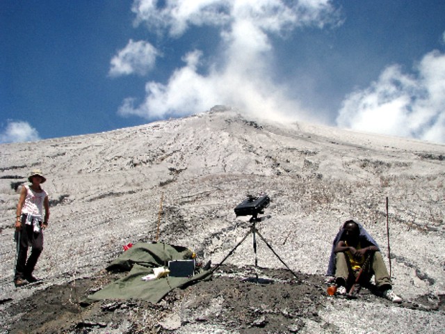 |
Figure 114. Mini-DOAS scan setup on 6 April 2008 on the W ascent route to Ol Doinyo Lengai. Courtesy of Maarten de Moor. |
On 7 April, observers saw no ash plume during their ascent, but detected an occasional faint sulfur odor. Mini-DOAS measurements were conducted about half-way up the volcano, while the volcano produced a faint, ash-free gas plume. Eight distinct ash layers were identified, described, and sampled ~ 600 m from the crater rim at an elevation of 2,428 m; the layers were sampled from a 51-cm-deep section through the ash deposits (figure 115). The thin, uppermost light gray ash layer was probably deposited from the light gray ash plume on 5 April 2008.
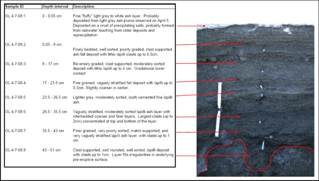 |
Figure 115. Photograph and description of eight distinct ash layers collected ~600 m from the Ol Dointo Lengai crater rim. (Sample location: 2.75664°S, 35.90729°E; at 2,428 m elevation). Courtesy of Maarten de Moor. |
At 1130 on 8 April 2008 activity was first noticed along the road from Lake Natron back to Engare Sero. Ash-rich explosions sent a plume ~ 500 m above the crater rim. Ash color was light to medium gray (lighter colored than ash from 6 April). Occasional ash clouds rose over the crater edge and flowed downslope (figure 116). Eruptions were quite consistent, with occasional 1-5 minute lulls. The ash plume drifted WNW. By 1600 the eruptive activity had decreased to longer lulls and less forceful explosions. Mini-DOAS measurements were conducted in the afternoon from the access road to the W ascent route.
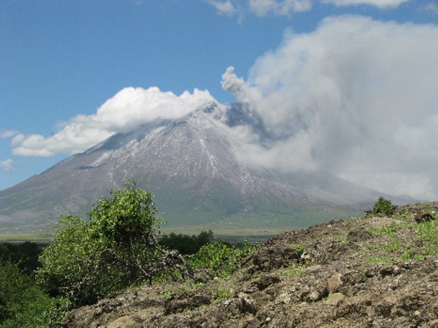 |
Figure 116. Pyroclastic flow with rising ash cloud at Ol Doinyo Lengai on 8 April 2008. Courtesy of Maarten de Moor. |
Activity during 3 August 2008. Ben Wilhelmi provided the following information from Remi Kahane about a climb on this day. Severin Polreich and Remi Kahane (of Arusha, Tanzania), and guides Godson (Arusha) and Juma (Maasai from Lake Natron village office), went on the old NE route to the summit. They spent 15 minutes at the rim of the crater at about 1000 and clearly heard strong constant rumbling, but saw no emissions. Fumaroles were present on the external rim and there was a strong sulfur odor.
Activity during 1 September 2008. Hervé Loubieres and Fran?oise Vignes of Toulouse climbed through the NW route with Shiro, their Maasai guide. They reported that this route on ash deposits was hard and long (7 hours), but without any difficulties. They reached the crater summit at 0700. While climbing they heard the roar of the volcanic activity before passing through the Pearly Gates. There were white fumaroles on the external rim of the crater, but with no smell of sulfur. Inside the crater on the S rim were also fumaroles, and on the crater floor there were two active vents erupting lava, one of them was bigger with a diameter around 10 m and permanently active. They descended at 0810 by the same route.
General References. Gilbert, C.D., and Williams-Jones, A.E., 2008, Vapour transport of rare earth elements (REE) in volcanic gas: Evidence from encrustations at Oldoinyo Lengai: Journal of Volcanology and Geothermal Research, v. 176, p. 519-528 (doi: 10.1016/j.volgeores.2008.05.003).
Teague, A.J., Seward, T.M., and Harrison, D., 2008, Mantle source for Oldoinyo Lengai carbonatites: Evidence from helium isotopes in fumarole gases: Journal of Volcanology and Geothermal Research, v. 175, p. 386-390 (doi: 10.1016/j.volgeores.2008.04.001).
Vaughan, R.G., Kervyn, M., Realmuto, V., Abrams, M., and Hook, S.J., 2008, Satellite measurements of recent volcanic activity at Oldoinyo Lengai, Tanzania: Journal of Volcanology and Geothermal Research, v. 173, p. 196-206 (doi: 10.1016/j.volgeores.2008.01.028).
Geological Summary. The symmetrical Ol Doinyo Lengai is the only volcano known to have erupted carbonatite tephras and lavas in historical time. The prominent stratovolcano, known to the Maasai as "The Mountain of God," rises abruptly above the broad plain south of Lake Natron in the Gregory Rift Valley. The cone-building stage ended about 15,000 years ago and was followed by periodic ejection of natrocarbonatitic and nephelinite tephra during the Holocene. Historical eruptions have consisted of smaller tephra ejections and emission of numerous natrocarbonatitic lava flows on the floor of the summit crater and occasionally down the upper flanks. The depth and morphology of the northern crater have changed dramatically during the course of historical eruptions, ranging from steep crater walls about 200 m deep in the mid-20th century to shallow platforms mostly filling the crater. Long-term lava effusion in the summit crater beginning in 1983 had by the turn of the century mostly filled the northern crater; by late 1998 lava had begun overflowing the crater rim.
Information Contacts: Frederick Belton, Developmental Studies Department, PO Box 16, Middle Tennessee State University, Murfreesboro, TN 37132, USA (URL: http://oldoinyolengai.pbworks.com/); Maarten de Moor, Department of Earth and Planetary Sciences, University of New Mexico, Albuquerque, NM 87131, USA; Hawai'i Institute of Geophysics and Planetology (HIGP) Thermal Alerts System, School of Ocean and Earth Science and Technology (SOEST), University of Hawai'i, 2525 Correa Road, Honolulu, HI 96822, USA (URL: http://modis.higp.hawaii.edu/); Jens Fissenebert, Molvaro-Lake Natron Tented Camp and Campsite, PO Box 425, Arusha, Tanzania (URL: http://www.ngare-sero-lodge.com/).