Report on Pacaya (Guatemala) — August 2008

Bulletin of the Global Volcanism Network, vol. 33, no. 8 (August 2008)
Managing Editor: Richard Wunderman.
Pacaya (Guatemala) During 2005 lava overtopped the collapse scarp to the inhabited N slopes
Please cite this report as:
Global Volcanism Program, 2008. Report on Pacaya (Guatemala) (Wunderman, R., ed.). Bulletin of the Global Volcanism Network, 33:8. Smithsonian Institution. https://doi.org/10.5479/si.GVP.BGVN200808-342110
Pacaya
Guatemala
14.382°N, 90.601°W; summit elev. 2569 m
All times are local (unless otherwise noted)
Our last Bulletin report discussed events at Pacaya as late as September 2005 (BGVN 30:10). Starting in 2005, lava flows from the active cone (MacKenney cone) substantially altered the local morphology and the consequent risks. The larger Pacaya complex's SW side is marked by an arcuate collapse scarp with relief up to 200 m. In 2005, for the first time, lavas accumulated in sufficient thickness to cross the NE portion of this barrier. If lavas advance substantially N from this point, they would descend steep slopes and could endanger hikers and residents.
Gustavo Chigna, of the Instituto Nacional de Sismologia, Vulcanologia, Meteorología, e Hidrologia (INSIVUMEH), mapped the substantial lava field N of the summit in 2008. In places, the flows that accumulated during 2005-08 reached 100-150 m thick (figure 35). The flows chiefly emerged from a new fissure on the upper NNE flank, constructing a protrusion from the MacKenney cone. As the lavas advanced they curved W, many ultimately reaching the N to NW sides of the active cone. Material venting within that crater sometimes formed small ephemeral cones that reached above the high point on the enclosing crater rim, but they always collapsed later.
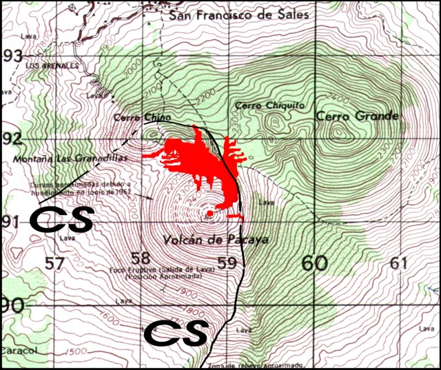 |
Figure 35. A topographic map of the Pacaya area from 1970 annotated to show lava flows emitted during 2005 through mid-2008. From a new fissure on the upper NNE flank, flows curved W, many reaching the N to NW sides of the active MacKenney cone (labeled "Pacaya"). Lava accumulated in the depression between the MacKenney cone to the S, the Cerro Chiquito and Cerro Grande cones to the N and NE, and the Cerro Chino cone to the NW. Between the latter three cones lies a comparatively flat area informally called la meseta; lava flows had crossed substantial portions of this area by 2006. Eruptions also deposited some lava on the cone's E side and in MacKenney crater. The upper margin of the collapse scarp (CS) is also indicated (light line). Ruled squares are 1 km to a side; heavy contours are 100 m. Courtesy of Gustavo Chigna. |
About 1,100 years ago Pacaya's SW side underwent a sector collapse, an event where a major part of the edifice collapsed, forming a debris avalanche that reached the Pacific coastal plain (Siebert and others, 2006). The edifice still bears an enormous scarp from this event. Within the horseshoe curve of this scarp, the MacKenney cone subsequently grew. It eventually rose to sufficient height to form the summit of the multi-peaked complex.
Although thick, rough-surfaced lava has emerged for years from the MacKenney cone to flow in various directions downslope, those during 2005-06 advanced in a new and unexpected way. In a manner similar to previous episodes, some of the N-flowing lavas descended into the depression and were confined to curve around the moat. In contrast, other lavas cooled and accumulated sufficiently to fill this portion of depression. The lavas ultimately overtopped the collapse scarp, and flowed onto the ancestral cone (figures 35 and 36).
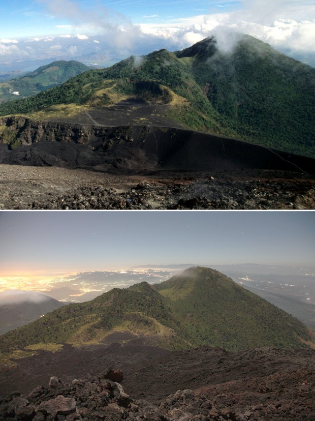 |
Figure 36. (top) A view in 2005 from Pacaya's summit (on the MacKenney cone) looking to the N with Cerro Grande the largest peak in view. Heavy tephra fall deposits covered the landscape in the field of view, the result of many years of Strombolian activity. At this stage the collapse scarp (steep ridge across the bottom third of the photo) still formed a significant topographic boundary. Activity during the photographer's visit was only fumarolic. (bottom) Night image of the same scene in December 2007; here the collapse scarp is absent, owing to inundation of the area by viscous rubbly lava. The narrow fingers of lava at distance reside on the meseta. Photos courtesy of Richard Roscoe (www.photovolcanic.com). |
Since restarting after about 76 years in 1961, the volcano has erupted lavas with only occasional breaks of months to a few years. The latest eruptive pulse began in 2004. The summit elevation of the MacKenney cone has varied due to the cone's repetitive growth and construction.
MODIS thermal alerts from the MODVOLC website were issued frequently for Pacaya during the reporting interval. The only months without alerts took place during the six-month interval of September 2005-February 2006, and December 2006. More precisely, these gaps in alerts spanned 29 August 2005-10 March 2006 and 29 November 2006-23 January 2007 (all local dates).
Pacaya resides just outside the southern topographic rim of Amatitlán caldera and ~ 30 km S of central Guatemala City (Lima and others, 2000). Maps of the setting and volcano appeared here most recently in BGVN 24:02 and 25:01. The National Park that includes Pacaya was created in July 1963 and it is a popular tourist destination (Bohnenberger, 1967). The trail along and to the meseta was crossed by lava flows during 2006 and later, hampering access and leading to risk concerns (figures 37-39).
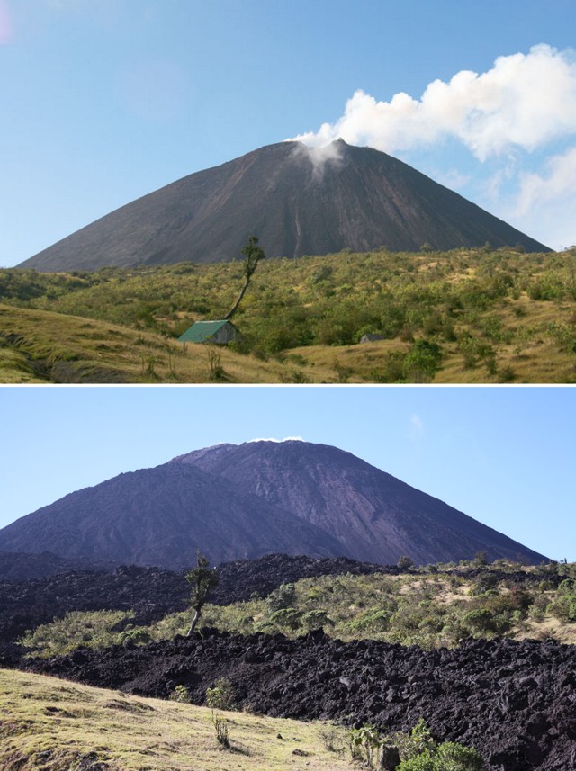 |
Figure 37. (top) Steaming MacKenney cone at Pacaya as viewed looking S from the main trail in 2005 from an area just below and S of the meseta. Note bending tree and structure(s) along depression in foreground. (bottom) Very similar view taken in December 2007. A large lava cone had formed on the N flank of MacKenney and lava flows had reached the trail during 2006 and 2007. The beleaguered tree still stands. Photos courtesy of Richard Roscoe (www.photovolcanic.com). |
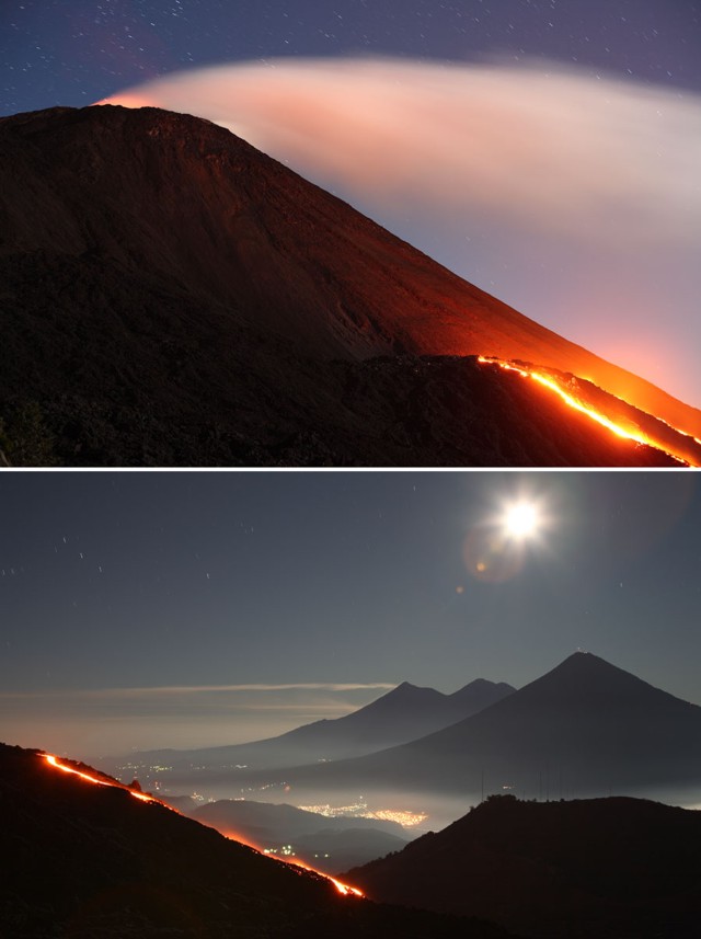 |
Figure 38. Nighttime (time-lapse) views of Pacaya's MacKenney cone as seen looking W in December 2007. (top) Summit incandescence and lava flows emerging from the cone's N flank. The latter constructed a lava cone that supported additional lava flows. (bottom) Flat-topped, antenna-laden Cerro Chino of the Pacaya complex is at lower right, and at distance in background from right to left reside Agua, Acatenango, and Fuego stratovolcanoes. Photos courtesy of Richard Roscoe (www.photovolcanic.com). |
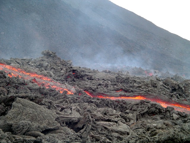 |
Figure 39. Daytime view of Pacaya's descending lava flows heading N on the shield area, 4 June 2006. The ribbon of lava trends remained linear, despite the flow field's surface irregularity. The margins appear partly contained by levees. Numerous other zones of glowing lava reside in the distance at lower elevation. Photo by AnaLu de MacVean. |
INSIVUMEH reports. Gustavo Chigna (INSIVUMEH) sent a report summarizing activity during 2005 through May 2008. He noted Strombolian activity during 1961-2000, typically with two to three paroxysmal eruptions each year. Those eruptions included falls of both ash and ballistic blocks, production of lava flows, and abundant gases escaping at the vent in the MacKenney cone's central crater. Pyroclastic flows were also mentioned, but without details. This eruptive pattern changed in the year 2000. The paroxysmal eruptions of January 2000, and 29 February 2000, and those continuing until September 2008 all chiefly consisted of steam-rich and ash-poor explosions.
During January-March 2005 a new phase of activity developed where the active cone emitted small batches of lava. This phase accompanied the repeated building and destruction of intracrater cones.
Observers in March-April 2005 saw the growth of N-S oriented cracks on the MacKenney crater, reaching 100-150 m in length and sometimes longer. Many of the cracks were 30-70 cm wide at the surface, and inspection revealed their open portions penetrated downwards about 1-8 m. Associated with these cracks, a depression became established on MacKenney cone's N side.
A new vent began emissions during a few days in mid-March and on 1 April 2005. Lava emerged from cracks on the cone's ENE side. In just a few days, the flow field from this vent grew to ~ 800 m long (figure 35). It curved to the W following the moat or valley floor (a comparatively flat area also called los llanos). By about 1 August 2005 this venting had sent many lava flows into the adjacent parts of the depression on the MacKenney cone's N flank. The rapid rate of lava accumulation during August filled up much of this part of the depression and eventually overtopped the scarp.
As the flows began to advance over the collapse scarp, alarm spread among residents of San Francisco de Sales, the town 1 km N of the flow front. The flows soon returned to advancing more to the W in the area confined by the collapse scarp and in the depression along los llanos.
The following year, after the 29 August 2005 and 10 March 2006 interval without thermal alerts, lava advanced onto a higher part of the meseta adjacent to a monument. This event is documented in two photos taken 27 July and 3 August (figure 40). Photos taken in August 2006 of the meseta show that the trail largely flow-covered (figure 41).
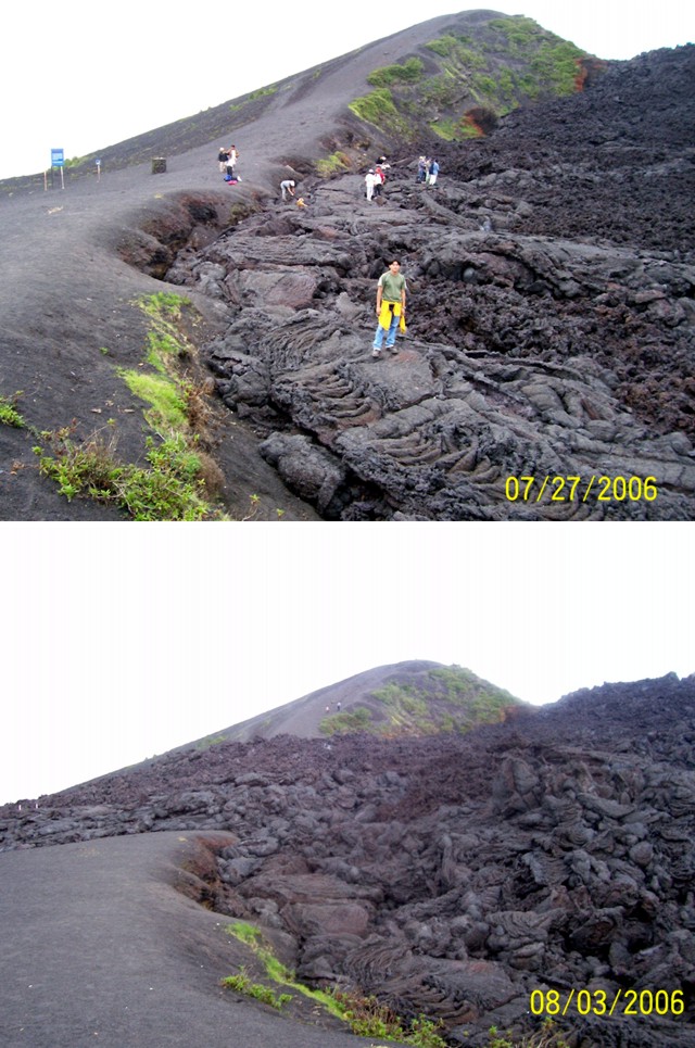 |
Figure 40. Cooled lava flows from Pacaya as seen looking along the collapse scarp to the S on (top) 27 July 2006 and (bottom) 3 August 2006. The MacKenney cone is out of the picture to the right. The flows on 27 July had nearly completely filled the depression N and NE of the meseta. By 3 August a flow crossed onto the meseta. Courtesy of Gustavo Chigna. |
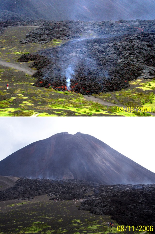 |
Figure 41. Two photos of Pacaya looking SE showing lava flows advancing across the meseta. (top) A flow lobe lay across the main trail on 8 August 2006. (bottom) Visitors confronting a new scene on 11 August 2006 at the meseta where the former trail was largely covered by rough-surfaced lava flows. Courtesy of Gustavo Chigna. |
The lava amassed between the MacKenney cone and meseta represented a rapid and remarkable morphologic change. Meseta historically provided an elevated viewpoint from which observations of Pacaya could be made. As a result of the new morphology, and assuming similar ongoing eruptions, hazards now confront N-flank villages and the main trail access route. INSIVUMEH plans to review hazard maps and strategies for this area.
References. Bohnenberger, O.H., 1967, Road log, Panajachel-Pacaya volcano, in Bonis, S. (ed.), Excursion Guidebook for Guatemala, Annual meeting Geol. Soc. Amer., IGN Guatemala, p. 25-30.
INSIVUMEH, 1970, Amatitlán, Guatemala map sheet, 1:50,000, HOJA 205911.
Lima Lobato, E.M., Fujino, T., and Palma Ayala J.C., 2000, Amatitlán geothermal field in Guatemala: Bull Geotherm Resour Council, v. 29, p. 215-220.
Momita, M., Fujino, T., Lima Lobato, E.M., and Palma, J., 2002, Conceptual model of Amatitlán, Guatemala: Chinetsu, v. 39, p. 11-32.
Siebert, L., Alvarado, G.E., Vallance, J.W., and van Wyk de Vries, B., 2006, Large-volume volcanic edifice failures in Central America and associated hazards, in Rose, W.I., Bluth, G.J.S., Carr, M.J., Ewert, J.W., Patino, L.C., and Vallance, J.W. (eds.), Volcanic hazards in Central America, Geol Soc Soc Amer Spec Pap, v. 412, p. 1-26.
Geological Summary. Eruptions from Pacaya are frequently visible from Guatemala City, the nation's capital. This complex basaltic volcano was constructed just outside the southern topographic rim of the 14 x 16 km Pleistocene Amatitlán caldera. A cluster of dacitic lava domes occupies the southern caldera floor. The post-caldera Pacaya massif includes the older Pacaya Viejo and Cerro Grande stratovolcanoes and the currently active Mackenney stratovolcano. Collapse of Pacaya Viejo between 600 and 1,500 years ago produced a debris-avalanche deposit that extends 25 km onto the Pacific coastal plain and left an arcuate scarp inside which the modern Pacaya volcano (Mackenney cone) grew. The NW-flank Cerro Chino crater was last active in the 19th century. During the past several decades, activity has consisted of frequent Strombolian eruptions with intermittent lava flow extrusion that has partially filled in the caldera moat and covered the flanks of Mackenney cone, punctuated by occasional larger explosive eruptions that partially destroy the summit.
Information Contacts: Gustavo Chigna, Instituto Nacional de Sismologia, Vulcanologia, Meteorologia e Hydrologia (INSIVUMEH), 7a Avenida 14-57, Zona 13, Guatemala City, Guatemala (URL: http://www.insivumeh.gob.gt/); Richard Roscoe (URL: http://www.photovolcanica.com); AnaLu de MacVean, Herbarium UVAL, Institute of Research, Universidad del Valle de Guatemala, 18 avenida 11-95 zona 15 V.H. III, Guatemala City, Guatemala (URL: http://herbario.uvg.edu.gt/).