Report on Kuchinoerabujima (Japan) — September 2008

Bulletin of the Global Volcanism Network, vol. 33, no. 9 (September 2008)
Managing Editor: Richard Wunderman.
Kuchinoerabujima (Japan) A rise in hazard status owing to 2008 seismicity and GPS-measured inflation
Please cite this report as:
Global Volcanism Program, 2008. Report on Kuchinoerabujima (Japan) (Wunderman, R., ed.). Bulletin of the Global Volcanism Network, 33:9. Smithsonian Institution. https://doi.org/10.5479/si.GVP.BGVN200809-282050
Kuchinoerabujima
Japan
30.443°N, 130.217°E; summit elev. 657 m
All times are local (unless otherwise noted)
Anomalous seismicity and inflation was noted at Kuchinoerabu-jima in late 2008. Seismic unrest was also reported during mid-1999 (BGVN 24:08). The island of the same name is home to ~ 140 residents and lies ~ 130 km S of the city of Kagoshima (Kyushu Island, Japan). The 19-km-diameter Kikai caldera, which is mainly submarine, sits a few tens of kilometers to the N, and is renowned for its massive eruption ~ 6,300 years ago. Kuchinoerabu Island contains a composite elongate cone made up of three closely spaced Holocene volcanoes supporting the island's S-central zone (figure 3; Geshi and Nakano, 2007; Geshi and Kobayashi, 2007).
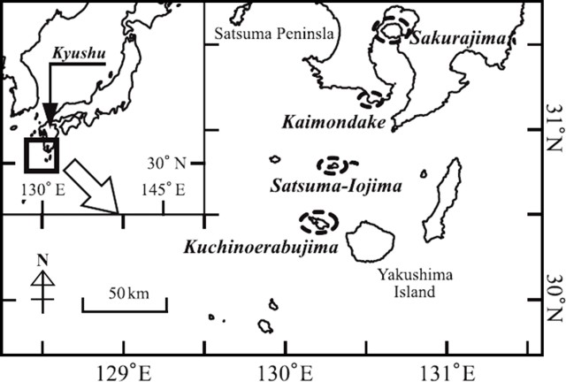 |
Figure 3. Map showing the location and geography of Kuchinoerabu-jima Island (Ryukyu Islands) south of Kyushu, Japan. The island is located ~ 15 km W of the larger circular Yaku-shima Island. The map also indicates recently active volcanoes of the region. Modified from Matsumoto and others (2007). |
Increased seismicity prompted the Japan Meteorological Agency (JMA) to raise the Alert Level from 1 to 2 (on a scale of 1-5) on 4 September 2008, and to level 3 on 27 October 2008. According to JMA, GPS measurements indicated inflation just below the summit crater that had started in September was continuing in October. Fumarolic activity near the summit had also increased.
Reference. Matsumoto, T., Ueno, H., and Kobayashi, T., 2007, A new secular variation curve for South Kyushu, Japan, and its application to the dating of some lava flows: Rep. Fac. Sci., Kagoshima Univ., no. 40, p. 35-49.
Geological Summary. A group of young stratovolcanoes forms the eastern end of the irregularly shaped island of Kuchinoerabujima in the northern Ryukyu Islands, 15 km W of Yakushima. The Furudake, Shindake, and Noikeyama cones were erupted from south to north, respectively, forming a composite cone with multiple craters. All historical eruptions have occurred from Shindake, although a lava flow from the S flank of Furudake that reached the coast has a very fresh morphology. Frequent explosive eruptions have taken place from Shindake since 1840; the largest of these was in December 1933. Several villages on the 4 x 12 km island are located within a few kilometers of the active crater and have suffered damage from eruptions.
Information Contacts: Volcanological Division, Seismological and Volcanological Department, Japan Meteorological Agency (JMA), 1-3-4 Ote-machi, Chiyoda-ku, Tokyo 100 Japan; Volcano Research Center (VRC-ERI), Earthquake Research Institute, University of Tokyo , Yayoi 1-1-1, Bunkyo-ku, Tokyo 113, Japan (URL: http://www.eri.u-tokyo.ac.jp/VRC/index_E.html).