Report on Long Valley (United States) — October 2008

Bulletin of the Global Volcanism Network, vol. 33, no. 10 (October 2008)
Managing Editor: Richard Wunderman.
Long Valley (United States) Comparative calm continues during 2006 into early 2008
Please cite this report as:
Global Volcanism Program, 2008. Report on Long Valley (United States) (Wunderman, R., ed.). Bulletin of the Global Volcanism Network, 33:10. Smithsonian Institution. https://doi.org/10.5479/si.GVP.BGVN200810-323822
Long Valley
United States
37.7°N, 118.87°W; summit elev. 3390 m
All times are local (unless otherwise noted)
The Long Valley Observatory (LVO) of the United States Geological Survey (USGS) monitors and studies earthquakes, ground deformation, degassing, and other types of geologic unrest in and around the Long Valley caldera. The LVO posts hazard status as a color code in one of four categories: green, yellow, orange, and red (the most serious response). The Long Valley caldera (figures 39 and 40) is located along the E side of the Sierra Nevada in east-central California. The hazard status remained at Green throughout 2007-2008.
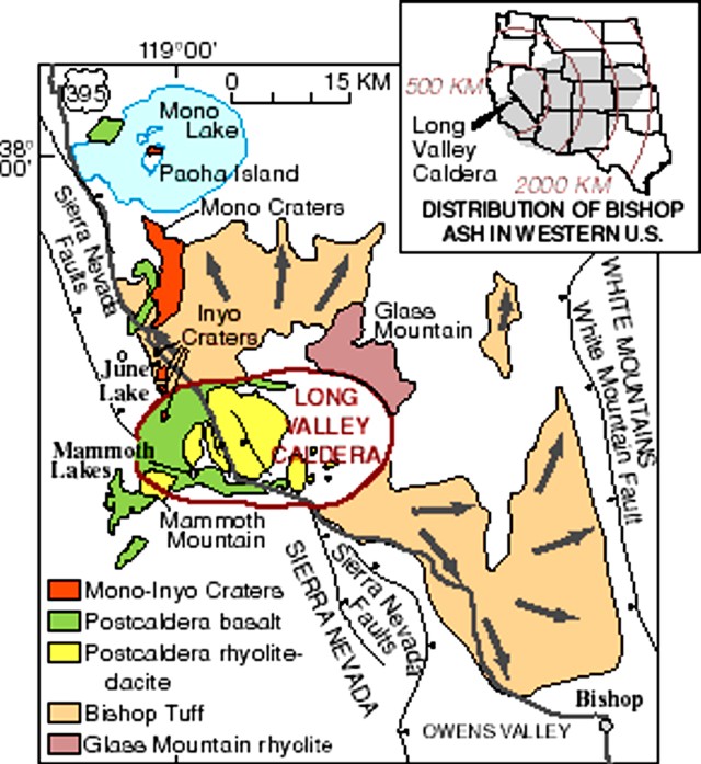 |
Figure 39. Map of Long Valley showing volcanic area just E of the Sierra Nevada mountain range. Courtesy of the USGS/LVO. |
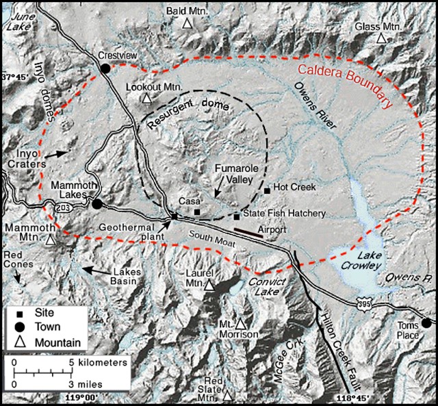 |
Figure 40. Map of Long Valley caldera showing internal resurgentdome location. Courtesy of the USGS/LVO. |
The broad resurgent dome in the caldera had essentially stopped inflating in early 1998, then slowly subsided so that by the end of 2006, the center of the resurgent dome was 75-80 cm higher than its height before the unrest in 1980. Seismic activity during 2006 within the caldera remained low with earthquakes less than than M < 2.0. The largest earthquake in the region was an M 4.3 event near Grinnell Lake in the Sierra Nevada 16 km S of the caldera. Brief sequences of small (M < 1.7), rapid-fire earthquakes (spasmodic bursts) beneath Mammoth Mountain occurred on 19 September and 23-24 November 2006.
During 2007, the Long Valley caldera remained comparatively quiet. Earthquake activity within the immediate confines of the caldera included minor swarms beneath Mammoth Mountain on 17-26 January and 13 March and a swarm beneath the SE margin of the resurgent dome (2.5 km WSW of Hot Creek) on 13-15 March . The largest of these swarm earthquakes was a M 2.1 event on 15 March located ~ 2.5 km WSW of Hot Creek. Earthquake activity in the Sierra Nevada S of the caldera was greater than activity within the caldera. The largest earthquake in the region was a M 4.6 event on 12 June near Lake Dorothy (1.5 km SSW of Mount Morrison 9 km SSE of the caldera's margin). Aftershocks to this earthquake persisted through the remainder of June and included ~ 27 earthquakes of M > 2. A cluster of small earthquakes occurred on 21 December 2007; the largest was recorded at M 1.7.
On 22 November 2008, three earthquakes large enough to be located by the automatic earthquake detection system broke the quiescence at Long Valley and the area south of the volcano. One, magnitude M 1.4, was located beneath the resurgent dome inside the caldera. The others, M 1.7 and M 1.3, were located to the S in the Sierra Nevada.
Between 25 November and 1 December 2008, 13 minor earthquakes occurred in the Long Valley area. All were below magnitude 2.0; one was located N of Round Valley and the rest were S of the caldera in the Sierra Nevada.
As of November 2008, the carbon dioxide (CO2) flux in the vicinity of Mammoth Mountain remained high but showed evidence of a gradual decline since 1995. The relatively high diffuse CO2 gas flux of 50-150 tons/day in the Horseshoe Lake tree-kill area (16.6 km SSE of Long Valley and 2.67 km SE of Mammoth mountain) has been relatively constant over the past several years. Sporadic episodes of geysering in Hot Creek that began May 2006 continued through December 2007, but at a declining rate.
Geological Summary. The large 17 x 32 km Long Valley caldera east of the central Sierra Nevada Range formed as a result of the voluminous Bishop Tuff eruption about 760,000 years ago. Resurgent doming in the central part of the caldera occurred shortly afterwards, followed by rhyolitic eruptions from the caldera moat and the eruption of rhyodacite from outer ring fracture vents, ending about 50,000 years ago. During early resurgent doming the caldera was filled with a large lake that left strandlines on the caldera walls and the resurgent dome island; the lake eventually drained through the Owens River Gorge. The caldera remains thermally active, with many hot springs and fumaroles, and has had significant deformation, seismicity, and other unrest in recent years. The late-Pleistocene to Holocene Inyo Craters cut the NW topographic rim of the caldera, and along with Mammoth Mountain on the SW topographic rim, are west of the structural caldera and are chemically and tectonically distinct from the Long Valley magmatic system.
Information Contacts: David Hill, Long Valley Observatory, U.S. Geological Survey, 345 Middlefield Rd., MS 977, Menlo Park, CA 94025, USA (URL: https://volcanoes.usgs.gov/observatories/calvo/).