Report on Sumbing (Indonesia) — November 2008
Bulletin of the Global Volcanism Network, vol. 33, no. 11 (November 2008)
Managing Editor: Richard Wunderman.
Sumbing (Indonesia) False report of an eruption plume in August 2008
Please cite this report as:
Global Volcanism Program, 2008. Report on Sumbing (Indonesia) (Wunderman, R., ed.). Bulletin of the Global Volcanism Network, 33:11. Smithsonian Institution. https://doi.org/10.5479/si.GVP.BGVN200811-263220
Sumbing
Indonesia
7.384°S, 110.07°E; summit elev. 3371 m
All times are local (unless otherwise noted)
The announcement of an eruption in the Smithsonian/USGS Weekly Volcanic Activity Report (30 July-5 August 2008) was later found to be false. The Darwin Volcanic Ash Advisory Center (VAAC) noted that a pilot reported an eruption plume from Sumbing on 1 August 2008. The plume allegedly rose to an altitude of 4.9 km and drifted W. However, ash was not identified on satellite imagery. Center of Volcanology and Geological Hazard Mitigation (CVGHM) observers at the local observatory saw only non-eruptive processes at the volcano, and they noted brush fires in September and October. A common problem in this active region occurs when drifting plumes become linked to the wrong volcano. After discussing the field observations, both Darwin VAAC and Indonesia's CVGHM concluded the report was in error. No thermal anomalies have been detected by the MODIS/MODVOLC satellite system for the volcano since 5 October 2006.
The area of Mt. Sumbing, close to Mt. Sundoro (also known as Sindoro) on Java (figure 1), was the subject of a recent study of people's perceptions and reactions to volcanic hazards (Lavignea and others, 2008). Note that there is another stratovolcano named Sumbing on Sumatra. In addition, one of the domes of Kelut (Java) is known as Sumbing.
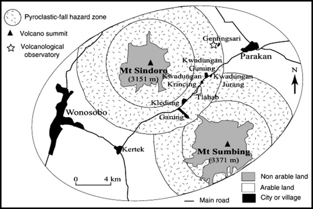 |
Figure 1. Area around the twin active volcanoes of Sumbing and Sundoro. Note the nearby volcanological observatory at Gentingsari. The circles around the volcano summits represent radii of ~4 and 6 km from the summit. From Lavignea and others (2008). |
Reference. Lavignea, F., De Costerb, B., Juvinb, N., Flohicb, F., Gaillardc, J-C., Texierd, P., Morine, J., and Sartohadif, J., 2008, People's behaviour in the face of volcanic hazards: Perspectives from Javanese communities, Indonesia: Journal of Volcanology and Geothermal Research, v. 172 (3-4), p. 273-287.
Geological Summary. Gunung Sumbing is a stratovolcano that is the SE-most edifice of a chain of volcanoes in central Java that includes Sundoro and the Dieng Complex. Prominent cones are located on the N and SE flanks. An 800-m-wide summit crater is breached to the NE, but is partially filled by a lava dome that fed a flow down to 2,400 m elevation. Emplacement of the dome followed the eruption of extensive pyroclastic flows down the NE flank. Activity reported in about 1730 CE may have produced the small phreatic craters found at the summit.
Information Contacts: Darwin Volcanic Ash Advisory Centre (VAAC), Bureau of Meteorology, Northern Territory Regional Office, PO Box 40050, Casuarina, NT 0811, Australia (URL: http://www.bom.gov.au/info/vaac/); Center of Volcanology and Geological Hazard Mitigation (CVGHM), Saut Simatupang, 57, Bandung 40122, Indonesia (URL: http://vsi.esdm.go.id/).