Report on Poas (Costa Rica) — January 2009
Bulletin of the Global Volcanism Network, vol. 34, no. 1 (January 2009)
Managing Editor: Richard Wunderman.
Poas (Costa Rica) Fatalities from a large nearby earthquake; slides and minor eruption in crater
Please cite this report as:
Global Volcanism Program, 2009. Report on Poas (Costa Rica) (Wunderman, R., ed.). Bulletin of the Global Volcanism Network, 34:1. Smithsonian Institution. https://doi.org/10.5479/si.GVP.BGVN200901-345040
Poas
Costa Rica
10.2°N, 84.233°W; summit elev. 2697 m
All times are local (unless otherwise noted)
On 8 January 2009, at 1321, the M 6.2 Chinchona earthquake shook Poás volcano, killing 23 people and injuring 100 in nearby communities. Another seven people were missing. A reported 1,087 houses were destroyed or damaged, with level VII damage on the Modified Mercalli intensity scale. The epicenter (figure 88) was on the Vara Blanca Fault at the village of Vara Blanca, 6-10 km E of Poás. Over 1,500 aftershocks were recorded during 8-9 January. Eruptive activity did not increase around that time, although a small phreatic eruption took place on 12 January. As of early March 2009, no thermal alerts had been detected by MODVOLC.
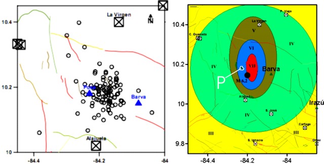 |
Figure 88. (left) Earthquake epicenters at Poás on 7-8 January 2009. (right) Mapping of the 8 January 2009 earthquake's Modified Mercalli intensity. Poás (P) was in region VI just W of the center of the intensity VII region and NW of the main-shock's epicenter (heavy dot). Both maps courtesy of the University of Costa Rica. |
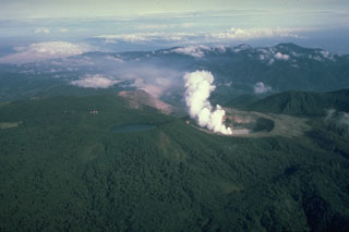
The morning before the earthquake volcanologists from the Observatorio Vulcanologico Sismologica de Costa Rica-Universidad Nacional (OVSICORI-UNA) and the University of New Mexico had entered the crater to sample fumaroles and the lake. The lake color at that time was a light blue-gray with yellow rings of sulfur 30-m wide that sank within minutes. The lake temperature was 52°C with a pH of 0. A 1-m-thick gas layer hovered over the lake surface. Fumarolic activity from an area S of the crater lake had increased, with a plume rising 150 m (figure 89).
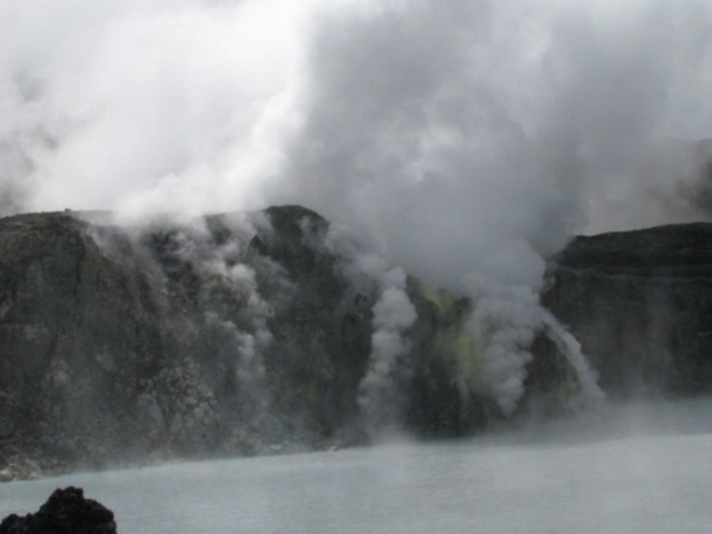 |
Figure 89. The acidic lake and degassing dome at Poás as seen on 8 January 2009. Courtesy of Univ. of Costa Rica and Univ. of New Mexico. |
The earthquake triggered significant landslides from the crater walls (figure 90), destroying part of the access trail to the bottom of the crater. There was a distinct shift in the color of the ground surface in many places where mass wasting had occurred. The older surface was commonly gray, whereas the freshly mobile material appeared in shades of brown to ochre. Rockslides carried blocks over a meter in size (figure 91) down the N and E crater walls. The volcanologists were able to escape the crater at the end of the day through the SSW wall ascending toward Botos lake.
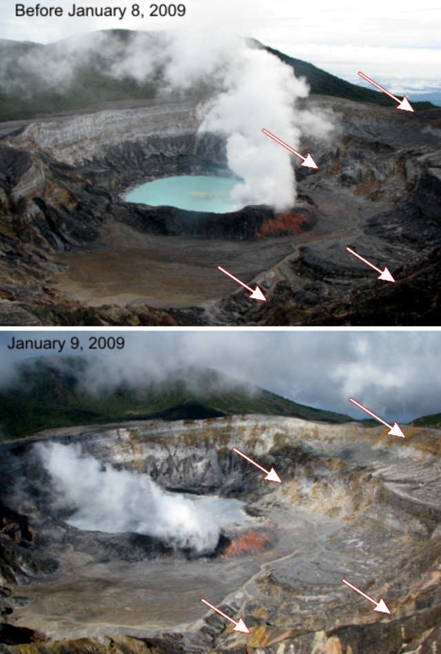 |
Figure 90. Poás crater before, and the day after, the earthquake of 8 January 2009. Arrows show zones where rockslides ultimately took place on the E crater walls. Courtesy of Univ. of Costa Rica and Univ. of New Mexico. |
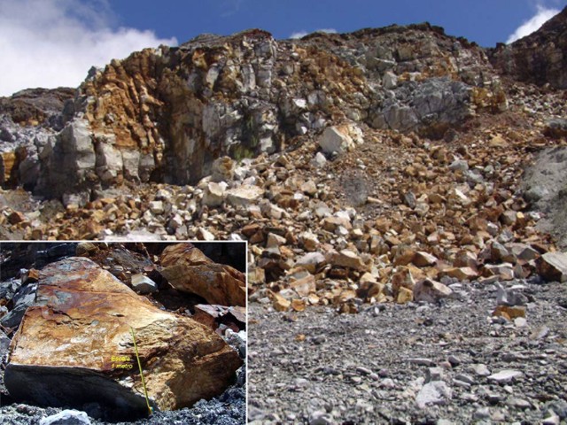 |
Figure 91. Photo of the east terrace that partially collapsed as the result of the 8 January 2009 earthquake. Many of these blocks were over a meter in diameter (inset) . Freshly exposed surfaces had ochre to brown to rust colors. Courtesy of OVSICRI-UNA. |
On 12 January 2009, scientists observed rising black sediment in the crater lake. A small phreatic eruption from a 50-m-diameter area at the center of the lake ejected sediment and water about 15 m high. Small phreatic eruptions had also been reported on 16 December 2006 and 13 January 2008 (BGVN 32:09 and 32:12).
On 11 February, a month after the earthquake, OVSICORI officials who visited the volcano saw abundant concentric-shaped landslides along the crater walls. According to Eliecer Duarte and others, the landslides numbered in the hundreds and ranged greatly in size. Gravitationally unstable areas were the most affected, but many other rockslides occurred along walls previously thought to be stable. A previously unstable area, E and near the lake, collapsed almost completely, burying a fumarolic area that had been active for about nine years. Vigorous degassing returned to the dome, and vapor covered the hot lake. Compared to recent years, fumarolic activity from the dome appeared stronger and more sustained.
Geological Summary. The broad vegetated edifice of Poás, one of the most active volcanoes of Costa Rica, contains three craters along a N-S line. The frequently visited multi-hued summit crater lakes of the basaltic-to-dacitic volcano are easily accessible by vehicle from the nearby capital city of San José. A N-S-trending fissure cutting the complex stratovolcano extends to the lower N flank, where it has produced the Congo stratovolcano and several lake-filled maars. The southernmost of the two summit crater lakes, Botos, last erupted about 7,500 years ago. The more prominent geothermally heated northern lake, Laguna Caliente, is one of the world's most acidic natural lakes, with a pH of near zero. It has been the site of frequent phreatic and phreatomagmatic eruptions since an eruption was reported in 1828. Eruptions often include geyser-like ejections of crater-lake water.
Information Contacts: E. Duarte, E. Fernández, T. Marino, R. Mora, and C. Ramirez, Observatorio Vulcanologico Sismologica de Costa Rica-Universidad Nacional (OVSICORI-UNA), Apartado 86-3000, Heredia, Costa Rica (URL: http://www.ovsicori.una.ac.cr/); Tobias Fischer, Maarten de Moor, Kareen Prade, Danielle Lord, and Jody Weikart, University of New Mexico, Department of Earth and Planetary Sciences, Northrop Hall, 200 Yale Blvd. NE, Albuquerque, NM 87131, USA.