Report on Hunga Tonga-Hunga Ha'apai (Tonga) — March 2009
Bulletin of the Global Volcanism Network, vol. 34, no. 3 (March 2009)
Managing Editor: Richard Wunderman.
Edited by Edward A. Venzke.
Hunga Tonga-Hunga Ha'apai (Tonga) Eruption ends on 21 March, leaving new land and steaming lakes
Please cite this report as:
Global Volcanism Program, 2009. Report on Hunga Tonga-Hunga Ha'apai (Tonga) (Venzke, E.A., and Wunderman, R., eds.). Bulletin of the Global Volcanism Network, 34:3. Smithsonian Institution. https://doi.org/10.5479/si.GVP.BGVN200903-243040
Hunga Tonga-Hunga Ha'apai
Tonga
20.5532°S, 175.3841°W; summit elev. 114 m
All times are local (unless otherwise noted)
The eruption from Hunga Tonga-Hunga Ha'apai (figure 6) that began from multiple vents at Hunga Ha'apai island on 17 March 2009 ended after five days of activity on 21 March. The eruption destroyed all vegetation on the island, one of two high points on a submarine caldera rim (figure 7). Strong Surtseyan activity was witnessed by passengers on a fishing boat on 18 March (BGVN 34:02). Satellite imagery acquired that day (figure 8) revealed a bright eruption plume, an extensive 10-km-radius zone of discolored water around the islands, and pumice rafts that had already drifted 20-25 km towards the NW. By the next day, scientists on the scene observed that the submarine vent offshore to the S (figure 9) had built new land that was connected to Hunga Ha'apai (BGVN 34:02).
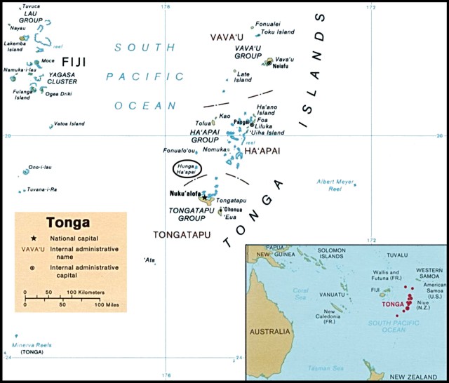 |
Figure 6. Political map of Tonga, 1989, showing the Vava'u, Ha'apai, and Tongatapu island groups. Hunga Ha'apai is in the oval about 55 km NNW of Tongatapu Island. Map courtesy of the University of Texas Libraries, The University of Texas at Austin. |
 |
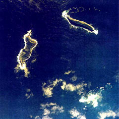
Figure 7. Aerial photo showing the vegetated islands of Hunga Tonga (right) and Hunga Ha'apai (left) before the eruption. Courtesy of Brad Scott, GNS Science. |
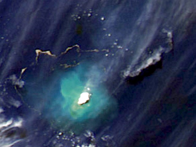 |
Figure 8. Aqua MODIS satellite image showing the eruption plume drifting NE and pumice rafts from Hunga Ha'apai on 18 March 2009. Hunga Tonga and Hunga Ha'apai are covered by the bright steam plume and surrounded by discolored water caused by suspended sediments reaching a maximum of about 10 km from the island. A detached older plume, possibly ash-bearing, is to the NE. Serpentine-shaped pumice rafts are drifting in the NW sector at a distance of 20-25 km from the island. Contrast has been enhanced. Courtesy of NASA Earth Observatory. |
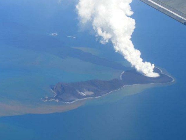 |
Figure 9. Aerial photo showing the island of Hunga Ha'apai with a steam plume rising from the vent in the newly created portion of the island. Emissions can also be seen in the vicinity of the small lake (left) marking the location of another vent active during this eruption. Discolored water surrounds the island, but a denser plume of material is originating from the shoreline near the small lake. View is looking SSE on an unknown date, March 2009. Courtesy of AusAID in Tonga. |
Based on inspection of an aerial photograph taken on 21 March (figure 10), the island had lengthened by ~ 1 km and the S crater was approximately 350 m in diameter on 21 March, assuming the island was 2 km long as previously described. Calculations using ASTER satellite imagery from 26 March result in similar dimensions for the island and S crater, and showed that the new extension was also about 1 km wide at that time.
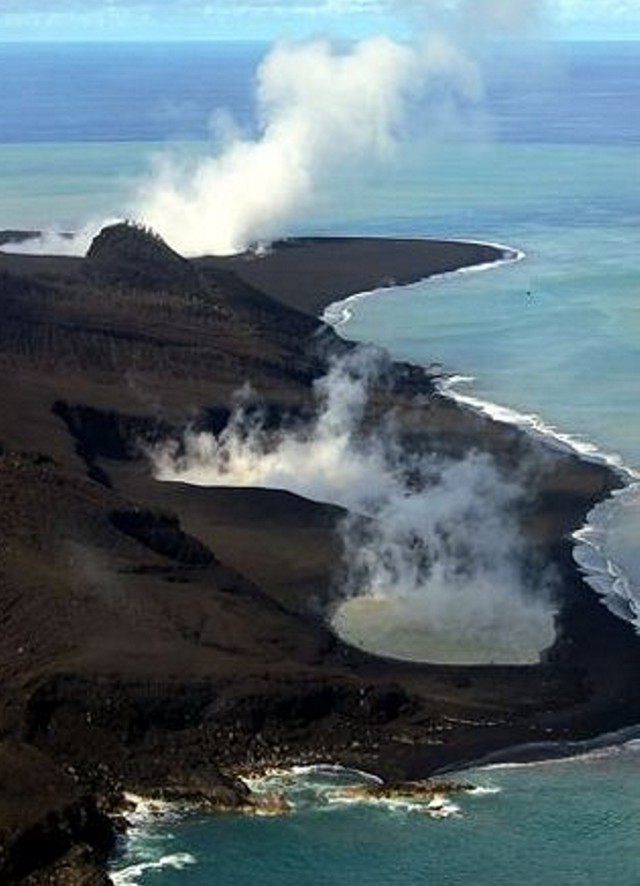 |
Figure 10. Aerial photo of the W side of Hunga Ha'apai island showing two steaming lakes in the NW vent area and a steam plume rising from the vent on the new southern part of the island. View is to the S on 21 March 2009. Courtesy of GP Orbassano and the Waterfront Lodge. |
Aerial photographs from 21 March showed no activity at the NW vent and a steam plume rising from the S vent. However, airport observers on Tongatapu saw new eruptive activity with ash plumes on the afternoon of 21 March (BGVN 34:02). A Matangi Tonga news article on 1 April reported the eruption as being on 17-21 March. Although Radio New Zealand International reported that residents of Nuku'alofa saw "glow on the horizon" on 22 March and stated that ash eruptions continued on the 23rd, those observations were not confirmed.
On 27 March a group of four people, organized by Gian Piero Orbassano of the Waterfront Lodge, landed on Hunga Ha'apai using an inflatable dinghy launched from a charter fishing boat. They landed on the newly built southern part of the island and walked to the rim of the crater which they described as filled with orange steaming water. They noted that landing on the "rocky black pumice" shore was difficult in rough seas. Large boulders (sizes not given) on the surface crumbled when touched. The ground was firm to walk on, but the crater rim was "fragile and cracked" (figure 11). Orbassano, in a 5 April news report, stated that people were visiting the island by boat but not landing, viewing the "smoking" vents and yellowish water around the island.
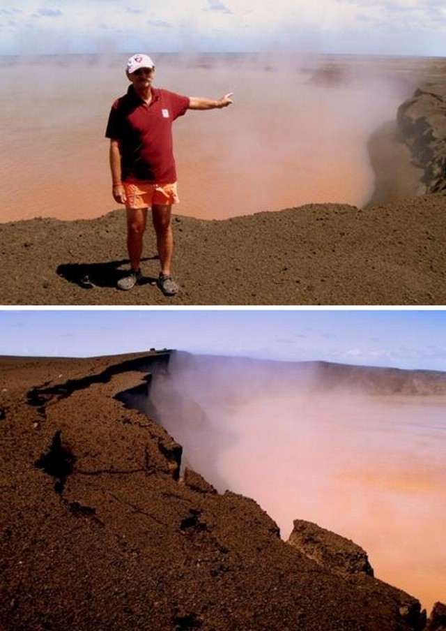 |
Figure 11. Photographs of the southern crater lake on newly formed land at Hunga Ha'apai, 27 March 2009. The steaming lake was colored orange-brown and the rim was unstable, as evidenced by the irregular rim, steep cliffs, and fractures. Courtesy of GP Orbassano and the Waterfront Lodge. |
Geological Summary. The small andesitic islands of Hunga Tonga and Hunga Ha'apai are part of the western and northern remnants of the rim (~6 km diameter) of a largely submarine caldera located about 30 km SSE of Falcon Island. The topmost sequence of welded and unwelded ignimbrite units from a caldera-forming eruption was 14C dated to 1040-1180 CE (Cronin et al., 2017; Brenna et al. 2022). At least two additional welded pumice-rich ignimbrite units and nonwelded pyroclastic flow deposits, below paleosols and other volcaniclastic deposits, indicated more very large previous eruptions (Cronin et al., 2017; Brenna et al. 2022). Several submarine eruptions have occurred at this caldera system since the first recorded eruption in 1912, including 1937 and S of the islands in 1988. A short eruption in 2009 added land to to Hunga Ha'apai. At that time the two islands were each about 2 km long, displaying inward-facing sea cliffs with lava and tephra layers dipping gently away from the caldera. An eruption during December 2014-January 2015 was centered between the islands, and combined them into one larger structure. Major explosive eruptions in late 2021 initially reshaped the central part of the combined island before stronger activity in mid-January 2022 removed most of the 2014-15 material; an even larger eruption the next day sent an eruption plume high into the stratosphere, triggered shock waves through the atmosphere and tsunami across the Pacific Ocean, and left only small remnants of the islands above the ocean surface.
Information Contacts: Brad Scott, GNS Science, Wairakei Research Centre, Private Bag 2000, Taupo 3352, New Zealand (URL: http://www.gns.cri.nz/); NASA Earth Observatory (URL: http://earthobservatory.nasa.gov/); GP Orbassano, Waterfront Lodge, Vuna Road, Ma'ufanga, PO Box 1001, Nuku'alofa, Tonga (URL: http://www.waterfront-lodge.com/); Radio New Zealand International, PO Box 123, Wellington, New Zealand (URL: http://www.rnzi.com/); Matongi Tonga Online, PO Box 958, Nuku'alofa, Tonga (URL: http://www.matangitonga.to/); Perry-Castañeda Library Map Collection, University of Texas Libraries, The University of Texas at Austin (URL: http://www.lib.utexas.edu/).