Report on Popocatepetl (Mexico) — March 2009

Bulletin of the Global Volcanism Network, vol. 34, no. 3 (March 2009)
Managing Editor: Richard Wunderman.
Popocatepetl (Mexico) Tremor, numerous earthquakes, and small ash plumes
Please cite this report as:
Global Volcanism Program, 2009. Report on Popocatepetl (Mexico) (Wunderman, R., ed.). Bulletin of the Global Volcanism Network, 34:3. Smithsonian Institution. https://doi.org/10.5479/si.GVP.BGVN200903-341090
Popocatepetl
Mexico
19.023°N, 98.622°W; summit elev. 5393 m
All times are local (unless otherwise noted)
Our most recent report on Popocatépetl (BGVN 32:04) described minor explosions, sporadic ash plumes, and lava dome growth during 2006 through April 2007. The current report discusses activity from April 2007 through April 2009, when many small ash plumes were noted.
From April 2007 through April 2009, the Centro Nacional de Prevencion de Desastres (CENAPRED) reported modest activity at Popocatépetl, consisting largely of numerous low intensity earthquakes and tremors (figures 54 and 55), and constant degassing of low intensity steam and gas, often accompanied by ash emissions of variable intensity. Based on information from the Mexico City Meteorological Watch Office (MWO), and the Washington Volcanic Ash Advisory Center (VAAC), there were 17 occasions when ash plumes rose at least 1 km above Popocatépetl's 5.4 km summit (table 19).
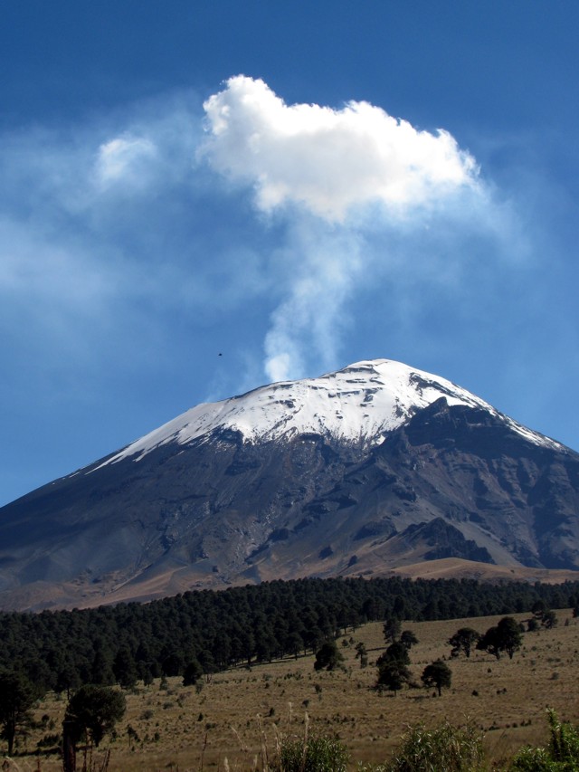 |
Figure 54. Popocatépetl upper flanks seen looking SSE in October 2008. During the reporting interval, steam plumes often hung over Popocatépetl's summit. The summit area is steep and glacial covered. The volcano's crater is deep and contains a growing dome of uncertain volume. Photo taken by Julie Roberge, UNAM. |
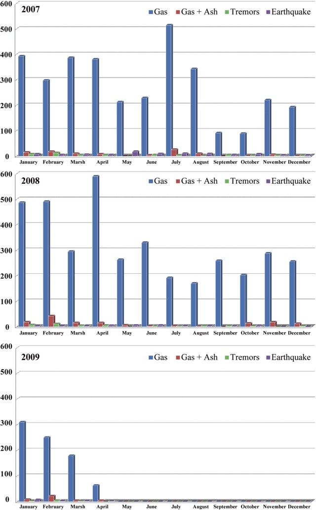 |
Figure 55. Histogram of selected annual activity at Popocatépetl. The number of earthquakes, tremors, gas, and gas + ash episodes per month between January 2007 and 1 April 2009. The amount of ash in the eruptions was modest, compared to total gas emissions. Courtesy of Julie Roberge. |
Table 19. Tabulation of ash plumes rising at least 1 km above Popocatépetl's summit between 1 April 2007 and 1 April 2009. Data provided by the Mexico City Meteorological Watch Office (MWO), and the Washington Volcanic Ash Advisory Center (VAAC) and a web camera operated by the Centro Nacional de Prevención de Desastres (CENAPRED).
| Date | Plume altitude (km) | Plume direction |
| 01 Apr 2007 | 7.6 | NE |
| 28 Jun 2007 | 6.4 | SSW |
| 28 Jul 2007 | 7 | WSW |
| 01 Dec 2007 | 7.4-9.1 | N, NE |
| 31 Dec 2007 | 7.4 | E, SE |
| 05 Jan 2008 | 7.3 | E, NE |
| 28 Jan 2008 | 8.6 | NW |
| 12 Feb 2008 | 7 | NE |
| 21-22 Feb 2008 | 7.4 | NE |
| 08-09 Mar 2008 | 6.4 | NE |
| 17 Mar 2008 | 7.4-7.9 | NE |
| 17 Nov 2008 | 6.1 | NW, WSW |
| 21 Jan 2009 | 7 | E, NE |
| 22 Jan 2009 | 7.4 | -- |
| 13 Feb 2009 | 7.2 | NE |
| 23 Mar 2009 | 6.7 | SE |
| 01 Apr 2009 | 6.4 | -- |
According to information provided by the Mexican National University geologist Julie Roberge, the tremors lasted from minutes to hours and varied in frequency and amplitude, but were mostly of low amplitude. The microearthquakes were also of low magnitude (M 2-3) with variable depths; epicenters were typically within 10 km of the crater. Plumes consisting of gas, and gas and ash, and seismicity consisting of earthquakes and tremor varied during 2007 through April 2009 (figure 55).
According to Roberge and others (2009), the deep degassing observed in the ongoing eruption of Popocatépetl may indicate an essentially intrusive event, rather than a convective process. The hypothesis of deep magma degassing beneath Popocatépetl is consistent with observations regarding degassing at the summit that suggest separation of magma and gas at depth beneath the volcano. According to additional information provided us by Roberge, the high gas flux is not associated with processes in the central conduit. The volcano has an elliptical crater (600 m by 800 m). Most of the lava that formed domes was extruded through the crater's major central vent (about 30 m wide). However, several other vents were formed in the crater during the explosive events of 1995. These vents are aligned N-S, and the largest has been the site of long term degassing but only rare extrusion of lava. The smaller secondary vents are ephemeral and their activities depend on the explosive events that reopen them. Often, the most vigorous release of gas occurs from the E vent, and thus much of the degassing seems unrelated to the central vent and conduit from which the lava domes form.
Between April 2007 and April 2009, thermal anomalies at Popocatépetl were detected every month by MODVOLC. The number of thermal anomalies per month ranged from three to seventeen, mostly one pixel, but occasionally two pixels, and once three pixels.
As reported in BGVN 32:04, a lava dome irregularly growing since July 2005 covered the floor of the internal crater. People studying the volcano have lacked an image of the dome and crater since 2007, leaving its later status and volume uncertain.
Reference. Roberge, J., Delgado-Granados, H., and Wallace, P. 2009. Mafic magma recharge supplies high CO2 and SO2 gas fluxes from Popocatépetl volcano, Mexico: Geology v. 37, no. 2, pp. 107-110.
Geological Summary. Volcán Popocatépetl, whose name is the Aztec word for smoking mountain, rises 70 km SE of Mexico City to form North America's 2nd-highest volcano. The glacier-clad stratovolcano contains a steep-walled, 400 x 600 m wide crater. The generally symmetrical volcano is modified by the sharp-peaked Ventorrillo on the NW, a remnant of an earlier volcano. At least three previous major cones were destroyed by gravitational failure during the Pleistocene, producing massive debris-avalanche deposits covering broad areas to the south. The modern volcano was constructed south of the late-Pleistocene to Holocene El Fraile cone. Three major Plinian eruptions, the most recent of which took place about 800 CE, have occurred since the mid-Holocene, accompanied by pyroclastic flows and voluminous lahars that swept basins below the volcano. Frequent historical eruptions, first recorded in Aztec codices, have occurred since Pre-Columbian time.
Information Contacts: Centro Nacional de Prevencion de Desastres (CENEPRED), Av. Delfín Madrigal No.665. Coyoacan, México D.F. 04360, México (URL: https://www.gob.mx/cenapred/); Washington Volcanic Ash Advisory Center (VAAC), Satellite Analysis Branch (SAB), NOAA/NESDIS E/SP23, NOAA Science Center Room 401, 5200 Auth Road, Camp Springs, MD 20746, USA (URL: http://www.ospo.noaa.gov/Products/atmosphere/vaac/); Julie Roberge, Instituto de Geología, Dept. Geoquimíca, Universidad Nacional Autonóma de México (UNAM), Ciudad Universitaria, Coyoacán D.F.(Federal District of Mexico City) 04510, Mexico.