Report on Sangeang Api (Indonesia) — July 2009
Bulletin of the Global Volcanism Network, vol. 34, no. 7 (July 2009)
Managing Editor: Richard Wunderman.
Sangeang Api (Indonesia) Increased seismicity, including explosion earthquakes, during May-June 2009
Please cite this report as:
Global Volcanism Program, 2009. Report on Sangeang Api (Indonesia) (Wunderman, R., ed.). Bulletin of the Global Volcanism Network, 34:7. Smithsonian Institution. https://doi.org/10.5479/si.GVP.BGVN200907-264050
Sangeang Api
Indonesia
8.2°S, 119.07°E; summit elev. 1912 m
All times are local (unless otherwise noted)
According to the Center of Volcanology and Geological Hazard Mitigation (CVGHM), restlessness began at Sangeang Api in May and June 2009. In early May 2009 white emissions reached heights of ~ 5-25 m. In addition, occasional explosion earthquakes and generally minor seismicity continued (table 3). In addition, an earthquake struck on 1-2 June 2009 that was felt at a Modified Mercali intensity of MM I.
Table 3. Summary of reported volcanic activity at Sangeang Api. Courtesy of the Center of Volcanology and Geological Hazard Mitigation (CVGHM).
| Date | Explosions | Tremor and amplitude | Deep volcanic earthquakes | Shallow volcanic earthquakes |
| 01-17 May 2009 | Avg. ~3/day | continuous, 3 mm | Avg. ~2/day | ~1/day |
| 18-31 May 2009 | ~13/day | continuous, 7 mm | ~4/day | ~2/day |
| 01-02 Jun 2009 | ~21/day | continuous, 5 mm | ~2/day | 1/day |
| 03 Jun 2009 | 11 | continuous, 6 mm | 7 | -- |
On 4 June the Alert Level was raised to 2 (on a scale of 1-4) due to the increases in the number of explosion earthquakes, tremor, and other local earthquakes. Residents and visitors were prohibited from climbing the volcano. No thermal anomalies have been seen in MODIS imagery between 1999 and August 2009.
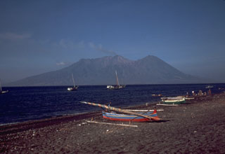
Geological Summary. Sangeang Api volcano, one of the most active in the Lesser Sunda Islands, forms a small 13-km-wide island off the NE coast of Sumbawa Island. Two large trachybasaltic-to-tranchyandesitic volcanic cones, Doro Api and Doro Mantoi, were constructed in the center and on the eastern rim, respectively, of an older, largely obscured caldera. Flank vents occur on the south side of Doro Mantoi and near the northern coast. Intermittent eruptions have been recorded since 1512, most of them during in the 20th century.
Information Contacts: Center of Volcanology and Geological Hazard Mitigation (CVGHM), Jalan Diponegoro 57, Bandung 40122, Indonesia (URL: http://vsi.esdm.go.id/).

