Ol Doinyo Lengai
Tanzania
2.764°S, 35.914°E; summit elev. 2962 m
All times are local (unless otherwise noted)
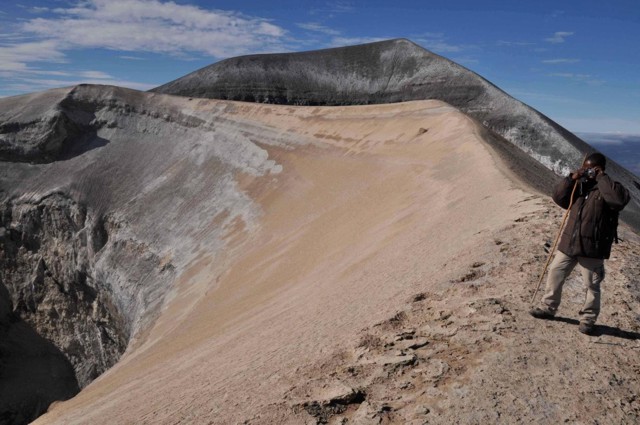
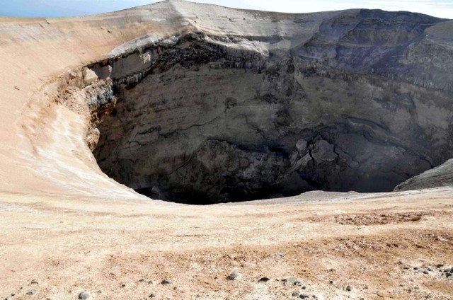
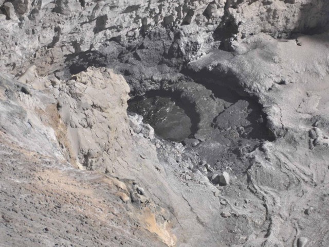
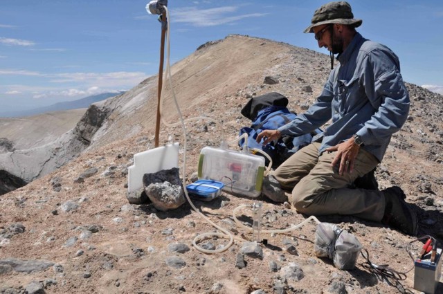
Our most recent report on Ol Doinyo Lengai discussed observations from several climbing groups and pilots during April 2008 through January 2009 (BGVN 34:05). This report reflects observations made during 11-12 June 2009 (figures 129-133) by a scientific team composed of Maarten deMoor (University of New Mexico), David Hilton and Peter Barry (Scripps Institution of Oceanography, UCSD), Fredrick Mangasini (University of Dar es Salaam), Carlos Ramirez (University of Costa Rica), and Tobias Fischer (University of New Mexico).
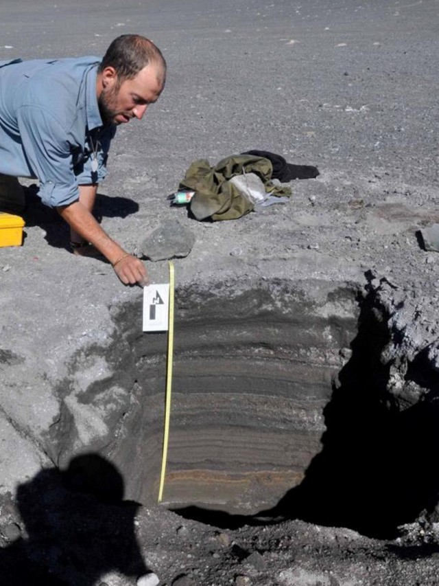
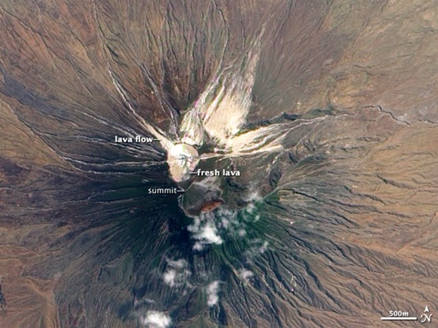
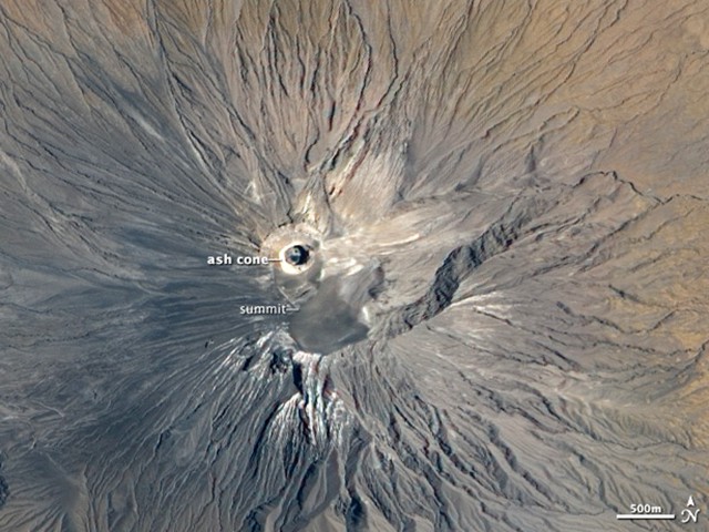
The team stated that on 11-12 June 2009, "carbonatite is currently erupting from hornitos and a lava lake [sits] at the bottom of the new (September 2007) crater" (figure 131). These conditions demonstrated both the establishment of a lava lake, less explosive activity, and more passive lava emissions on the crater floor. Comparison of satellite imagery from July 2004 (figure 134) and September 2009 (figure 135) provided by the NASA Earth Observatory website, showed the summit changes caused by the switch from generally effusive eruptions to a series of explosions beginning in 2007 (BGVN 32:11, 33:02). In September 2007, explosive eruptions began. sending ash thousands of meters into the air. Ash also covered the surrounding landscape, forcing local residents to flee with their livestock. Explosive eruptions continued into 2008, building a ring of fragmental material over 100 m high on the edge of the N crater. In satellite imagery acquired 12 September 2009 by the Advanced Land Imager (figure 135), the new cone and its deep concentric crater are clearly visible.
Reports on Fredrick Belton's website described the following visits during the summer of 2009. Table 23 is a continuation of the one in BGVN 35:05. A final statement on the website notes that, although activity appeared to have returned in August 2009 to the typical gentle eruptions of fluid natrocarbonatite lava, no samples of the new flows have been obtained for analysis due to their inaccessibility deep inside the steep-walled crater. Therefore, it remains uncertain how compositionally similar the new inaccessible lavas are compared to those produced prior to the 2007-2008 eruption.
Table 23. Summary of selected observations of Ol Doinyo Lengai (from a climb, aerial overflight, flank, or satellite) during June-August 2009. Courtesy of Frederick Belton.
| Date |
Observer |
Observation Location |
Brief Observations |
| 11-12 Jun 2009 |
Maarten deMoor, David Hilton, Peter Barry, Fredrick Mangasini, Carlos Ramirez, Tobias Fischer |
Climb |
See text above. |
| July 2009 |
David Gregson |
Climb |
No significant activity viewed, but heard sounds of activity at depth. |
| late Aug 2009 |
Thomas Holden |
Climb |
Viewed active lava flows. |
| 12 Sep 2009 |
Ben Wilhelmi |
Aerial |
See text below. |
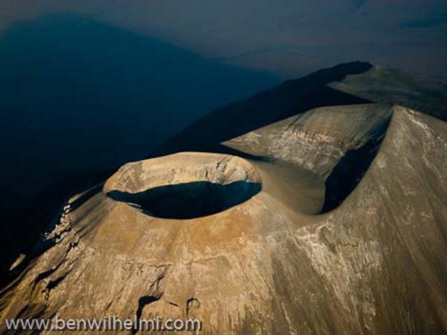
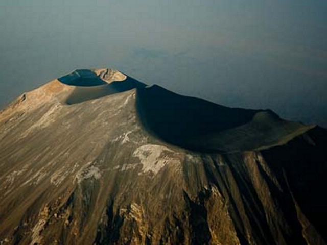
Ben Wilhelmi, a commercial pilot working in the region, sent us some recent aerial photographs taken on 12 September 2009. We present two of those photos featuring overviews of the summit complex (figures 136 and 137).
Geological Summary. The symmetrical Ol Doinyo Lengai is the only volcano known to have erupted carbonatite tephras and lavas in historical time. The prominent stratovolcano, known to the Maasai as "The Mountain of God," rises abruptly above the broad plain south of Lake Natron in the Gregory Rift Valley. The cone-building stage ended about 15,000 years ago and was followed by periodic ejection of natrocarbonatitic and nephelinite tephra during the Holocene. Historical eruptions have consisted of smaller tephra ejections and emission of numerous natrocarbonatitic lava flows on the floor of the summit crater and occasionally down the upper flanks. The depth and morphology of the northern crater have changed dramatically during the course of historical eruptions, ranging from steep crater walls about 200 m deep in the mid-20th century to shallow platforms mostly filling the crater. Long-term lava effusion in the summit crater beginning in 1983 had by the turn of the century mostly filled the northern crater; by late 1998 lava had begun overflowing the crater rim.
Information Contacts: Tobias Fischer, Department of Earth and Planetary Sciences, University of New Mexico, Albuquerque, NM 87131, USA; Frederick Belton, Developmental Studies Department, PO Box 16, Middle Tennessee State University, Murfreesboro, TN 37132, USA (URL: http://oldoinyolengai.pbworks.com/); NASA Earth Observatory (URL: http://earthobservatory.nasa.gov/); Ben Wilhelmi (URL: http://benwilhelmi.typepad.com/benwilhelmi/).