Report on Rinjani (Indonesia) — September 2009
Bulletin of the Global Volcanism Network, vol. 34, no. 9 (September 2009)
Managing Editor: Richard Wunderman.
Rinjani (Indonesia) More data relevant to eruptions during 2 May through at least 31 August 2009
Please cite this report as:
Global Volcanism Program, 2009. Report on Rinjani (Indonesia) (Wunderman, R., ed.). Bulletin of the Global Volcanism Network, 34:9. Smithsonian Institution. https://doi.org/10.5479/si.GVP.BGVN200909-264030
Rinjani
Indonesia
8.42°S, 116.47°E; summit elev. 3726 m
All times are local (unless otherwise noted)
A series of eruptions at Rinjani began on 2 May 2009 (BGVN 34:06). The current report, provided by Alain Bernard, presents additional data regarding these eruptions, which continued through 31 August 2009.
Studies of Rinjani volcanic lake are part of a cooperative agreement between Indonesia and Belgium, a collaboration funded by the Commission Universitaire pour le Développement (CUD, the main Belgian development cooperation agency for universities). Geochemical and physical studies of the Segara Anak lake started in the framework of this collaborative effort during the summer of 2006. During the summer of 2008, investigators installed a monitoring station for continuous measurements of the lake's level and temperature, and for meteorological parameters.
The scientific teams involved in this study were (Indonesia) Akhmad Solikhin, Devy Syabahna and Syegi Kunrat of the Center of Volcanology and Geological Hazards Mitigation (CVGHM); (Belgium) Alain Bernard, Benjamin Barbier, Robin Campion, and Corentin Caudron of the Université Libre de Bruxelles (ULB), and Vincent Hallet and David Lemadec of the Facultés Universitaires Notre Dame de la Paix (FUNDP).
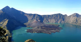
Segara Anak lake. The majestic Segara Anak lake filling the caldera of Rinjani covers an area of 11 km2. Prior to the 2009 eruption, the lake's volume was 1.02 km3. The lake-surface elevation is ~ 2 km (figures 11 and 12).
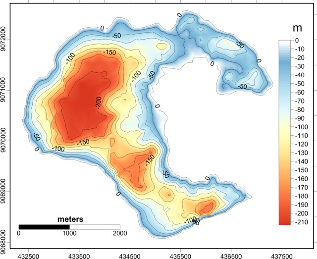 |
Figure 11. Bathymetric map of Rinjani's Segara Anak lake made from 65 km of echo-sounder surveys conducted in 2007 and 2008. Maximum depth of the lake is 205 m. Courtesy of the CVGHM, ULB, and FUNDP study team. |
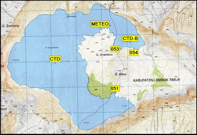 |
Figure 12. Topographic map of Rinjani caldera from Bakosurtanal-Indonesia (National Coordinator for Survey and Mapping Agency, Indonesia). Margins defining squares are 1 km long. "CTD" and "CTD-B" are locations of conductivity-temperature-depth profiles. "Meteo" is the site of the meteorological station monitoring air temperature, humidity, wind velocity, and net solar flux. The labels 51-54 are locations of hot springs discussed below. Courtesy of the CVGHM, ULB, and FUNDP study team. |
The lake is neutral (pH: 7-8) and its chemistry dominated by chlorides and sulfates with a relatively high concentration of total-dissolved solids (TDS: 2,640 mg/L). This unusually high TDS value and lake surface temperatures (20-22°C), well above ambient temperatures (14-15°C) for this altitude, reflects a strong input of hydrothermal fluids. Numerous hot springs are located along the shore at the foot of the Barujari cone. Bathymetric profiles showed several areas with columns of gas bubbles escaping from the lake's floor.
Precursory signals of the May 2009 eruption. Changes in Segara Anak lake and the hot springs before the first 2 May 2009 eruption included significant anomalies in the temperature and chemistry of the hot springs.
During field work 10-14 April 2009, the researchers noted an increase in temperature and acidity of hot springs 53 and 54 (figures 13-14) compared to July. This increasing acidity was confirmed in the lab as the consequence of an increase in sulfate levels not observed during studies since 2004.
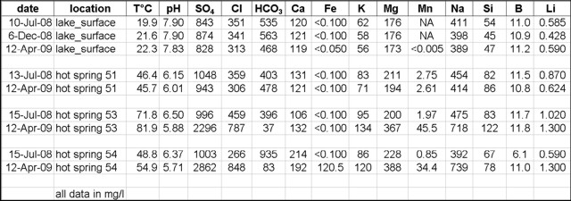 |
Figure 13. Geochemistry of Rinjani's Segara Anak lake (from CTD locations, figure 12) and hot springs. NA signifies not analyzed. Courtesy of the CVGHM, ULB, and FUNDP study team. |
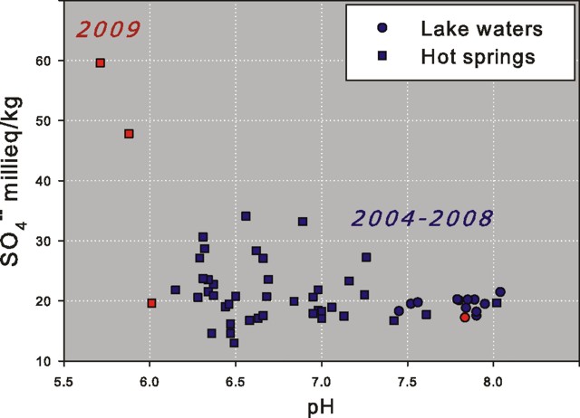 |
Figure 14. A plot of 2004 to 2009 sulfate (SO42-) ion concentration versus pH. Note the April 2009 increase in the acidity and sulfate contents of Rinjani's hot springs 53 and 54 (upper left). Courtesy of the CVGHM, ULB, and FUNDP study team. |
The Fe-ion concentrations in spring 54, usually below detection limits, peaked at 120 mg/L. This change in chemistry produced a yellowish-brown coloration of the lake waters because of the precipitation of ferric hydroxide, Fe(OH)3 (figures 15-16). An ASTER image from 21 August 2009, processed to enhance the Fe(OH)3 precipitates, revealed a chemical plume close to where hot springs 53 and 54 injected water into the lake.
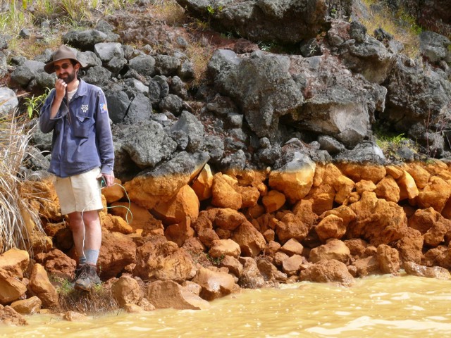 |
Figure 15. The Rinjani lake shoreline seen at a point close to the hot spring 54 on 12 April 2009. The water has a brown color and the coating on the rocks is an amorphous ferric hydroxide that precipitated when hydrothermal fluids oxidized by mixing with the lake waters (yellow-brown in color). Rock discoloration reaches the height of the mans lower hand. Changes in lake level were a consequence of the rainy season. Photo by A. Bernard. |
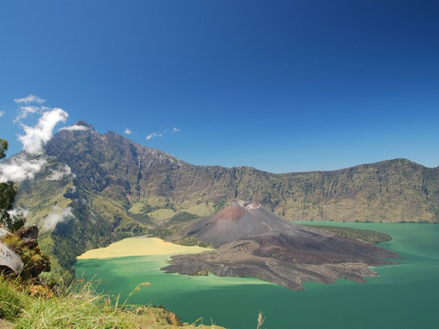 |
Figure 16. A photo of Rinjani and Segara Anak Lake thought to have been taken on 26 April 2009 but certainly before the start of the eruption. A spectacular yellow-brown chemical precipitate floated on the lake's surface (at left). Copyrighted photo by Jim Chow. |
A chemical plume of low pH and dissolved oxygen was observed at the lake surface extending up to several hundred meters away from hot spring 54. pH profiles as a function of depth recorded at several locations showed a clear acidification of Segara Anak lake especially at shallow depths (15-20 m) (figure 17). Rainfall in April 2009 caused a shallow zone of higher pH.
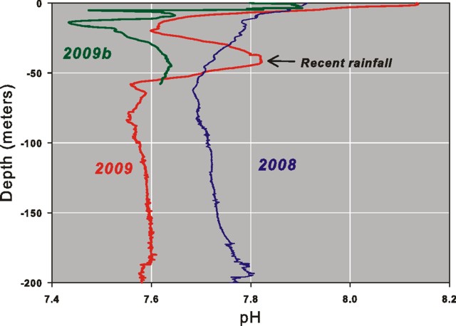 |
Figure 17. Plot showing shifts of pH in Rinjani's caldera lake waters with depth. The 2009 profile was recorded in April 2009, and the 2008 profile, in July 2008. Line 2009b was drawn as an estimate of the curve without the rainfall event. Measurements made with an SBE Seacat 19-Plus profiler. Courtesy of the CVGHM, ULB, and FUNDP study team. |
A slight lake surface temperature increase from 20°C in July 2008 to 22°C in early April 2009 was mostly attributed to meteorological effects. Large increases seen in lake level in January and February 2009 were the consequence of heavy rainfalls. Heating of the lake between August 2008 and April 2009 occurred mainly during periods with reduced heat loss to the atmosphere due to less wind.
A report of these field observations was made on 17 April to CVGHM, which prompted them to send another team to the volcano. The new team arrived at the summit of the volcano on 2 May 2009, the day the eruptions started.
Eruptive activity May-August 2009. The 2009 eruptions originated from the same vent of the October 2004 activity (figure 18), and was characterized by mild eruptions that produced a small lava flow and low altitude, ash-poor gas plumes (figure 19). Contrary to that reported in some newspapers, the 2009 eruption did not open a new vent.
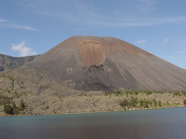 |
Figure 18. This July 2006 photo of Rinjani illustrates the new vent that opened on the NE slope of Gunung Baru in 2004 and then produced a short lava flow. The 2009 eruptive activity at Rinjani started from this same vent, producing a significant lava flow that entered the crater lake and built a delta. Photo by A. Bernard (July 2006). |
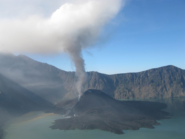 |
Figure 19. Eruption of Rinjani seen on 10 June 2009. The plume at this point was relatively small and lava proceeded N to enter the lake. Photo by R. Campion. |
Alain Bernard sent a report by Robin Campion (ULB) who was on site June 2009. According to Campion, mild activity was observed from the SE rim during 9-11 June. Pressurized incandescent gas was released at a 1-2 second intervals from a vent located in the 2004 crater, on the S flank of Barujari. At variable intervals (10 seconds to 10 minutes), stronger gas jets ejected lava fragments to heights up to 100 m. Occasional ash ejections occurred from a second vent in the same crater. A third lower vent emitted a viscous lava flow that reached Segara Anak Lake. Contact between the lake and the lava delta resulted in a warm surface current (figure 20).
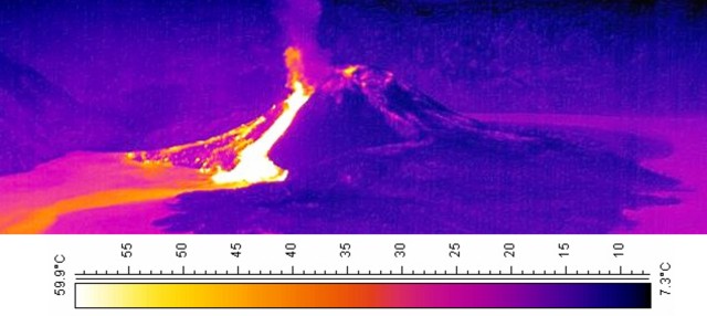 |
Figure 20. A 10 June 2009 FLIR thermal camera image of Rinjani's Barujari cone and Segara Anak lake. A thermal plume of hot lake water was drifting from the lava entry points. Temperature scale is for lake waters. Photo by R. Campion. |
Figure 21 shows an ASTER satellite image of Rinjani lake-surface temperatures. Increased discharge of the hot springs on the S flank of Barujari produced a distinct plume with an orange-red color. Weak winds carried the steam-and-gas plume (with low ash content) N and W at an altitude of 3-4 km. Activity did not vary during the 3-day observation period.
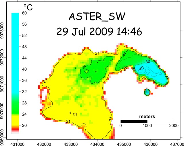 |
Figure 21. ASTER satellite image of the N part of Rinjani's Segara Anak lake taken on 29 July 2009 (at 1446 UTC). Thermal infrared bands 13 and 14 processed with a split-window algorithm. Contours are in degrees C. Maximum temperature in the lake water was 57°C. Courtesy of the CVGHM, ULB, and FUNDP study team. |
As of 31 August 2009, the eruption was still underway. At that point, the new lava flow covered an area of 0.65 km2 (figure 22). The shoreline had been significantly modified by the entry of lava into Segara Anak lake, and the lake surface area had been reduced by 0.46 km2 (figures 22 and 23).
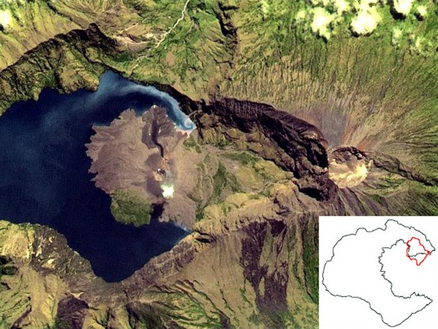 |
Figure 22. Rinjani seen in ASTER false color on 21 August 2009 (0235 UTC). The new lava covers an area of 650,000 m2 and significantly changed the shoreline. The inset shows the pre-eruption shoreline and the new lava margin (in red on colored versions). Courtesy of the CVGHM, ULB, and FUNDP study team. |
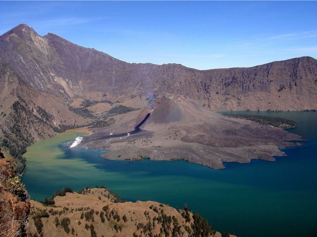 |
Figure 23. Rinjani, in a photo apparently taken on 4 August 2009, showing a new delta built into the lake. Brown waters from hot springs were still visible at the end of the lake and drifted over a large area of the lake. Courtesy of Arjo Vanderjagt. |
According to Alain Bernard, updates on Rinjani's activity will be posted on the website of the Commission of Volcanic Lakes (CVL, see information contacts). Bernard sent additional figures describing Rinjani behavior as late as 27 September 2009.
Geological Summary. Rinjani volcano on the island of Lombok rises to 3726 m, second in height among Indonesian volcanoes only to Sumatra's Kerinci volcano. Rinjani has a steep-sided conical profile when viewed from the east, but the west side of the compound volcano is truncated by the 6 x 8.5 km, oval-shaped Segara Anak (Samalas) caldera. The caldera formed during one of the largest Holocene eruptions globally in 1257 CE, which truncated Samalas stratovolcano. The western half of the caldera contains a 230-m-deep lake whose crescentic form results from growth of the post-caldera cone Barujari at the east end of the caldera. Historical eruptions dating back to 1847 have been restricted to Barujari cone and consist of moderate explosive activity and occasional lava flows that have entered Segara Anak lake.
Information Contacts: Alain Bernard, Benjamin Barbier, Robin Campion, and Corentin Caudron, Université Libre de Bruxelles (ULB), Belgium (Commission of Volcanic lakes, URL: http://www.ulb.ac.be/sciences/cvl/rinjani/rinjani.html); Akhmad Solikhin, Devy Syabahna, and Syegi Kunrat, Center of Volcanology and Geological Hazards Mitigation (CVGHM), Jalan Diponegoro 57, Bandung 40122, Indonesia (URL: http://vsi.esdm.go.id/); Vincent Hallet and David Lemadec, Facultés Universitaires Notre Dame de la Paix (FUNDP, URL: http://www.fundp.ac.be/); Bakosurtanal, Badan Koordinasi Survei dan Pemetaan Nasional (URL: http://www.bakosurtanal.go.id/); Jim Chow (URL: http://www.flickr.com/photos/11668976@N06/3486237730); Arjo Vanderjagt, Oude Boteringestraat 52, 9712 GL Groningen, The Netherlands (URL: http://www.flickr.com/photos/87453322@N00/3794836615).