Report on St. Helens (United States) — September 2009

Bulletin of the Global Volcanism Network, vol. 34, no. 9 (September 2009)
Managing Editor: Richard Wunderman.
St. Helens (United States) Eruption ceased in late January 2008; quiet continues in late 2009
Please cite this report as:
Global Volcanism Program, 2009. Report on St. Helens (United States) (Wunderman, R., ed.). Bulletin of the Global Volcanism Network, 34:9. Smithsonian Institution. https://doi.org/10.5479/si.GVP.BGVN200909-321050
St. Helens
United States
46.2°N, 122.18°W; summit elev. 2549 m
All times are local (unless otherwise noted)
The eruptive episode that began with the volcano reawakening in October 2004 (BGVN 29:09) ended in late January or early February 2008. The activity included explosions containing ash that rose up to ~ 3 km above the crater and lava dome growth. Sherrod and others (2008) provide a comprehensive discussion of the 2004-2006 portion of the eruption. This report spans 28 November 2007 through October 2009.
A GPS receiver on the W part of the active spine recorded continued SW advance at a rate of 3-4 mm per day during September through November 2007. During 28 November-4 December 2007, small inflation-deflation events occurred, which the USGS Cascades Volcano Observatory (CVO) interpreted as dome-growth pulses. On 31 December 2007 aerial observers saw a new small, snow-free spine on top of the active lobe.
On 25 January 2008, a steam plume rose from the dome slightly above the crater rim. Though seismicity had persisted at low levels through mid-February 2008, very few earthquakes were recorded after late January. Locatable earthquakes were fewer than one per day, all under M 2.0. Ground tilt measurements showed an overall subsidence in the area of the new dome. A GPS receiver on the previously active spine settled about 2 cm per day on a southward path. During February, the daily ground-tilt events stopped and gas emissions were barely detectable.
Comparison of photographs taken by remote cameras during late January to mid-February 2008 showed no evidence of extrusion. Cynthia Gardner (CVO), in a personal communication, noted that dome growth stopped in late January or early February (January 27 ± 10 days).
During March 2008, the most significant developments were a small, M 2.0 earthquake on 4 March and a very small earthquake swarm on 6 March. The latter started with a roughly M 1.2 event, followed by several smaller tremors over a seven-minute period. No tilt changes were associated with the swarm. On 14 March, the Pacific Northwest Seismic Network recorded four very small earthquakes located near the volcano. There were no tilt changes associated with this activity.
Radar imagery analyzed by Jet Propulsion Laboratory staff during late March 2008 showed that the E and W arms of Crater Glacier were touching, or close to touching, just N of the 1980s lava dome. From 30 May 2008 (figure 71) to 8 July 2008, the W arm of the glacier advanced ~ 20 m. By 8 July, the old and new lava domes in the crater were encircled by ice (figure 72). Further down slope glacier ice descended into the gullies that had been carved by erosion into the Pumice Plain. On 10 July, after nearly 5 months without signs of renewed activity, CVO lowered the Alert Level to Normal and the Aviation Color Code to Green.
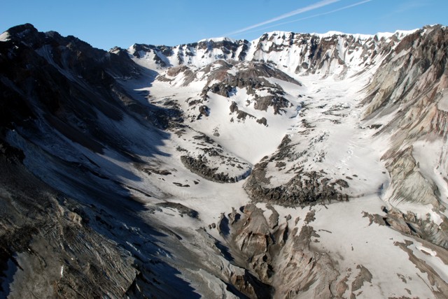 |
Figure 71. Aerial view of the St. Helens crater, as seen from the N. The two arms of the Crater Glacier had by 30 May 2008 fully encircled the dome. USGS photograph by Steve Schilling. |
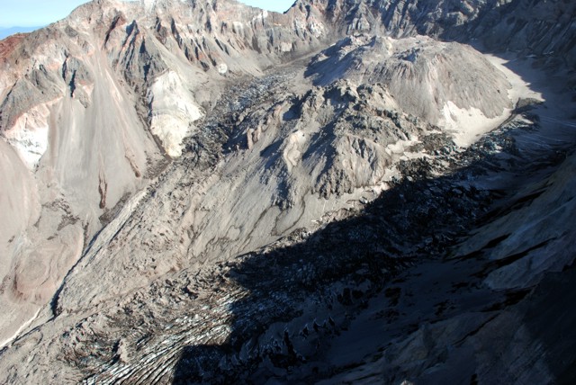 |
Figure 72. Old and new lava domes (center and upper right respectively) in the St. Helens crater encircled by ice, as seen from the NW. USGS photograph taken on 5 August 2009 by Steve Schilling. |
As of October 2009, earthquakes, volcanic gas emissions, and ground deformation had all fallen to levels observed prior to the onset of the eruption.
References. Lahusen, R.G., 2005, Acoustic flow monitor system?user manual: U.S. Geological Survey Open-File Report 02-429, 22 p.
Sherrod, D.R., Scott, W.E., and Stauffer, P.H., eds., 2008, A volcano rekindled: the renewed eruption of Mount St. Helens, 2004-2006: U.S. Geological Survey, Professional Paper 1750, 856 p.
Geological Summary. Prior to 1980, Mount St. Helens was a conical volcano sometimes known as the Fujisan of America. During the 1980 eruption the upper 400 m of the summit was removed by slope failure, leaving a 2 x 3.5 km breached crater now partially filled by a lava dome. There have been nine major eruptive periods beginning about 40-50,000 years ago, and it has been the most active volcano in the Cascade Range during the Holocene. Prior to 2,200 years ago, tephra, lava domes, and pyroclastic flows were erupted, forming the older edifice, but few lava flows extended beyond the base of the volcano. The modern edifice consists of basaltic as well as andesitic and dacitic products from summit and flank vents. Eruptions in the 19th century originated from the Goat Rocks area on the N flank, and were witnessed by early settlers.
Information Contacts: Cascades Volcano Observatory (CVO), U.S. Geological Survey, 1300 SE Cardinal Court, Building 10, Suite 100, Vancouver, WA 98683-9589, USA (URL: https://volcanoes.usgs.gov/observatories/cvo/); Pacific Northwest Seismic Network, University of Washington, Dept. of Earth and Space Sciences, Box 351310, Seattle, WA 98195-1310, USA (URL: http://www.pnsn.org/); Hawai'i Institute of Geophysics and Planetology (HIGP) Thermal Alerts System, School of Ocean and Earth Science and Technology (SOEST), Univ. of Hawai'i, 2525 Correa Road, Honolulu, HI 96822, USA (URL: http://modis.higp.hawaii.edu/).