Report on Turrialba (Costa Rica) — September 2009

Bulletin of the Global Volcanism Network, vol. 34, no. 9 (September 2009)
Managing Editor: Richard Wunderman.
Turrialba (Costa Rica) Non-eruptive in August 2009, but degassing and with widening cracks
Please cite this report as:
Global Volcanism Program, 2009. Report on Turrialba (Costa Rica) (Wunderman, R., ed.). Bulletin of the Global Volcanism Network, 34:9. Smithsonian Institution. https://doi.org/10.5479/si.GVP.BGVN200909-345070
Turrialba
Costa Rica
10.025°N, 83.767°W; summit elev. 3340 m
All times are local (unless otherwise noted)
The Observatorio Vulcanológico y Sismológico de Costa Rica, Universidad Nacional (OVSICORI-UNA) continued monitoring the Turrialba non-eruptive interval of February 2008 through August 2009. As during the previous four months (BGVN 33:01), Turrialba continued to emit sulfurous gas from its central and W craters, and elsewhere, including some new cracks.
Activity during February-December 2008. During February 2008, the area around Turrialba affected by acid rain increased due to degassing. The degassing vents on the N, NW, W, and SW walls were rich in sublimated native sulfur. Gas-emission temperatures ranged from 72 to 132°C. Owing to prevailing winds, the vegetation most affected was on the N, NW, and SW flanks. The effects ranged from discoloration to death of various plant species. Residents in the area reported occasional nausea and irritation of the skin and eyes. On 22 February, local observers reported a gas plume up to ~ 2 km in height.
On the SE and SW walls of the central crater two cracks 2-3 cm wide and 100 m long continued to emit gases at ~ 90°C and produced sulfur deposits (figure 13). In stable atmospheric conditions gas columns often rose ~ 500 m above the crater. Rockslides sometimes covered emitting fumaroles, and new sulfur deposits tended to develop in these areas.
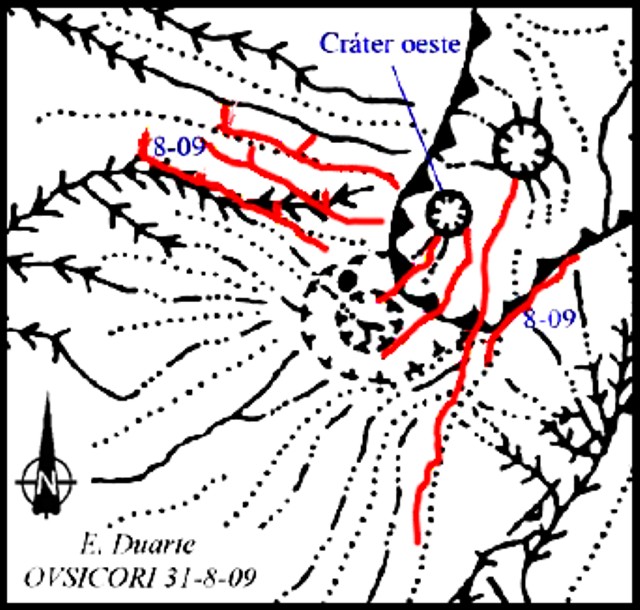 |
Figure 13. Elongated cracks (red lines on colored version) mapped at Turrialba during in August 2009. From first being noticed in mid-2009 to being measured in August 2009, some cracks opened by as much as 12 cm. Courtesy of OVSICORI-UNA. |
During 7-8 March 2008, gas sampling at the summit fumaroles determined the maximum temperature at the largest W wall vent was 278°C. Degassing vents were also noted at spots in the middle of the forest. In some cases emissions had killed all local vegetation.
On 7-8 March 2008, Erick Fernandez and Eliécer Duarte of OVSICORI, and the National University (UNA) took gas samples. The analysis, done by Jorge Andrés Diaz and Sergio Achí of the University of Costa Rica, revealed the presence of He at 80,000 ppm (parts per million), whereas the typical He concentration in the neighborhood of a volcano is 25 ppm.
OVSICORI-UNA reported continued degassing during August and September 2008. Multiple fumaroles and areas of sulfur deposition were noted in both the central and W craters. Fumarolic emissions on the S and SE flanks of the W crater continued to damage vegetation in that area.
On 23 September 2008, OVSICORI fieldwork confirmed a severe impact of acid-rain on areas that had been only mildly affected during the preceding 3 years of degassing. At least three sectors showed new impacts on vegetation and infrastructure, from the summit downhill ~ 3 km along the S and SE flanks. The upper sector, which includes the entire caldera and lower sectors to the E, S, and SE near the summit, had been severely burned during August and September. This area goes from the summit down to an elevation of ~ 2,900 m. By 23 September, weeds, dwarf vegetation, and trees had been completely burned; however in these areas some resistant species maintained some green and appeared seemingly viable. Along the external walls to the S of the W crater, plants had been burned down to the soil. Due to the removal of that natural coverage, erosion had cut extended radial gullies.
Between the elevations of 2,900 and 2,600 m, significant forest patches have been partially seared by extreme acidification, particularly the dense birch forests. Below 2,600 m elevation mild burns to the tree canopy and pasture areas were evident. The evidence of chemical burns due to the heavy gases are amplified along canyons and depressions. These conditions caused residents to voluntarily leave their farms in 2007.
Monitored SO2 emissions during the early part of 2008 had been ~ 750 metric tons per day (t/d). At the end of April 2008, an increase to ~ 1,000 t/d was noted, which then increased to ~ 2,000 t/d well into July. During the end of July the emissions declined to ~ 1,100 t/d. The increase in SO2 flux corresponded to increases in vegetation damage.
Activity during January-June 2009. In May 2009 OVSICORI reported ongoing fumarolic degassing during the preceding months from the central crater, from the N, NW, W, SW and S walls, from new vents on the S and SW walls, and other locations. Some locations continued to form sublimated sulfur deposits. The two cracks in the SE and SW walls had temperatures of ~ 87°C. The emissions in the W wall registered ~ 91°C and displayed sulfur deposits. In meteorologically quiet conditions, gas plumes were noted up to 500-600 m above the crater floor. All of these areas had experienced small landslides that occasionally covered some vents.
SO2 flux was variable during early 2009 (figure 14). The flux data were collected with a roughly consistent sun angle, between 0900 and 1100 in the morning on the SW flank. In the graph the SO2 flux varies between ~ 0 and ~ 2,000 t/d, the maximum flux occurred on 23 April.
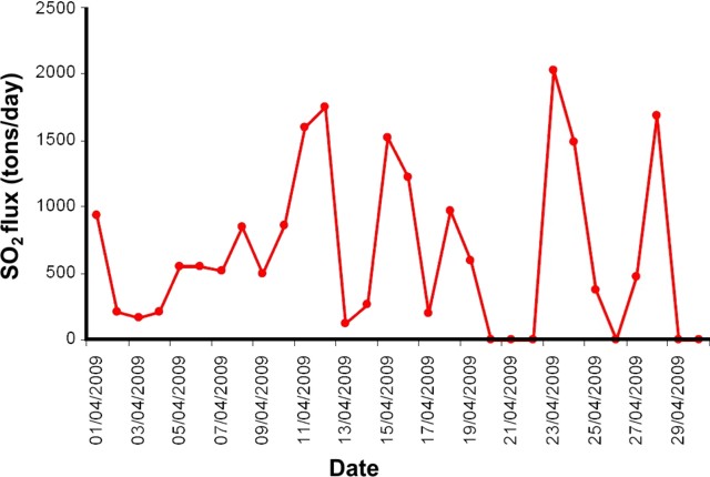 |
Figure 14. SO2 fluxes measured at Turrialba during April 2009 (with y-axis showing SO2 flux in metric tons per day and x-axis dates in the format, month/day/year). Courtesy of OVSICORI-UNA. |
On 14 June 2009, OVSICORI-UNA reported that fumarolic activity from Turrialba had been observed all around the upper flanks of the active W crater. During the previous two months, the fumarolic activity was also accompanied by widening radial cracks (1.5 cm on average), 1-2 km tall gas-and-vapor plumes, and one sustained seismic swarm. Temperatures of fumarolic vents in the lower parts of the crater were between 120 and 160°C. The temperature of summit cracks was 94°C. By mid-June, dairy pastures and forests had been chemically burned as far away as 3.5 km NW and W. During the last week of August 2009, the W and NW lower flanks, sectors previously reported with moderate effects, showed acute burns, and yellow pastures within 3 to 4 km radius (figures 15, 16, and 17).
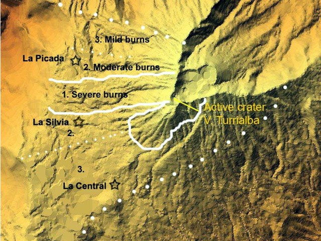 |
Figure 15. Vegetation damage as of late August 2009 at Turrialba plotted on a shaded relief map by F. Robichaud. E. Duarte and others found that damage was generally within several kilometers of the volcano and in broader areas on the W flanks. The large dotted line indicates the boundary of detectible damage. Severe damage covered an irregular area, a strip both directly W of the active crater and a lobe to its SW as well. Courtesy of OVSICORI-UNA. |
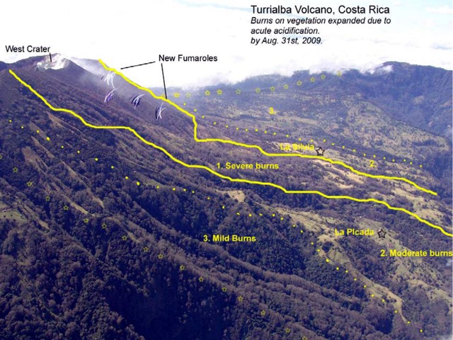 |
Figure 16. Newly emerging fumaroles on Turrialba's upper NW flank and burns on vegetation, August 2009. Courtesy of OVSICORI-UNA. |
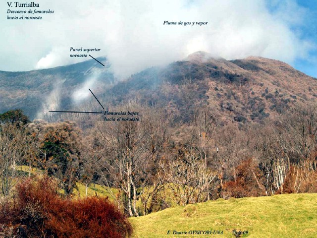 |
Figure 17. A view from Turrialba's seismic station PICA on the NW flank, showing active degassing from a variety of locations in August 2009. Left mid-ground shows plumes from the lowest fumaroles yet developed on this flank. Green grass is in the foreground, but most of the other foliage is brown to orange. Courtesy of OVSICORI-UNA. |
Near the Toro Amarillo river (4 km E of the crater) chemical burning surrounds stands of trees. Such whitening effect had been previously reported at the end of 2007 for areas closer to the active crater, 1.5 km W (figure 18).
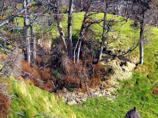 |
Figure 18. An example of a zone with intense burns on grass at the foot of injured trees, damage attributed to acidic gases from Turrialba. The spot is near the Toro Amarillo river in late August 2009. Courtesy of OVSICORI-UNA. |
Several elongated cracks were mapped just south of the W crater as well as 1 km downslope NW. One main crack, noticed during mid-2009 due to sulfur depositions on the surface, was opened by August in places as much as 12 cm. In late August 2009 it emitted gasses at 90°C. The crack trends E-W, in places intersecting a trail used to reach the summit's SW and W sides.
The last two years have caused residents to leave owing to the burned and dead pastures. Some commented on their apprehension related to the emergence of the lower fumaroles. Along the S side of the Irazú summit located 10 km SW of Turrialba's summit, mild burns have been observed on patches of birch, eucalyptus and pine. Lesser impact was reported last year in that same area.
False eruption report. The Washington VAAC received surface observations from an airport near the volcano erroneously indicating an eruption on the morning of 23 September 2009.
The VAAC decided to initially describe the activity as an eruption because it was the first time the airport had reported emissions, the volcano was known to have been degassing for some time, and early morning satellite imagery showed cloud cover, preventing good analysis. In addition, attempts to reach local volcanologists by telephone using contact numbers from the ICAO [International Civil Aviation Organization] handbook and the OVSICORI webpage were not successful. OVSICORI-UNA personnel reported a few hours later that the volcano had not erupted. As a result of the incident, the VAAC has obtained current contact numbers, including personal cell phones, for future use.
Geological Summary. Turrialba, the easternmost of Costa Rica's Holocene volcanoes, is a large vegetated basaltic-to-dacitic stratovolcano located across a broad saddle NE of Irazú volcano overlooking the city of Cartago. The massive edifice covers an area of 500 km2. Three well-defined craters occur at the upper SW end of a broad 800 x 2200 m summit depression that is breached to the NE. Most activity originated from the summit vent complex, but two pyroclastic cones are located on the SW flank. Five major explosive eruptions have occurred during the past 3500 years. A series of explosive eruptions during the 19th century were sometimes accompanied by pyroclastic flows. Fumarolic activity continues at the central and SW summit craters.
Information Contacts: Eliécer Duarte, Erick Fernández, Vilma Barboza, S. Miranda, L. Ortiz, G. Chavez, Jorge Brenes, Thomás Marino, Javier Pacheco, Juan Segura, and Rodolfo van der Laat, Observatorio Vulcanológico y Sismológico de Costa Rica, Universidad Nacional (OVSICORI-UNA), Apdo. 2346-3000, Heredia, Costa Rica (URL: http://www.ovsicori.una.ac.cr/); Francois Robichaud, Université de Sherbrooke, 2500 boul. de l'Université, Sherbrooke, Québec J1K 2R1, Canada; Washington Volcanic Ash Advisory Center, Satellite Analysis Branch (SAB), NOAA/NESDIS E/SP23, NOAA Science Center Room 401, 5200 Auth Rd, Camp Springs, MD 20746, USA (URL: http://www.ospo.noaa.gov/Products/atmosphere/vaac/).