Report on Reventador (Ecuador) — September 2009

Bulletin of the Global Volcanism Network, vol. 34, no. 9 (September 2009)
Managing Editor: Richard Wunderman.
Reventador (Ecuador) Lava flows seen and SO2 fluxes recorded during 16-17 September 2009
Please cite this report as:
Global Volcanism Program, 2009. Report on Reventador (Ecuador) (Wunderman, R., ed.). Bulletin of the Global Volcanism Network, 34:9. Smithsonian Institution. https://doi.org/10.5479/si.GVP.BGVN200909-352010
Reventador
Ecuador
0.077°S, 77.656°W; summit elev. 3562 m
All times are local (unless otherwise noted)
Activity at Reventador between August 2008 and late April 2009 was a period of generally low seismicity (BGVN 34:03). During early November 2008 repeated small eruptions occurred with steam-and-ash plumes, Strombolian eruptions, and lava flows. This report continues coverage through October 2009, an interval that included new lava flows advancing ~ 500 m by mid-September 2009.
Based on analysis of satellite imagery, the Washington Volcanic Ash Advisory Center (VAAC) reported that on 1 May a thermal anomaly over Reventador occurred along with a possible low plume drifting W. The Instituto Geofísico-Escuela Politécnica Nacional (IG) reported to the VAAC the presence of lava and gas emissions and possible smoke from burning vegetation, but little to no ash.
On 15 May, the IG observed an ash emission, although neither an ash signature nor a thermal anomaly was detected in satellite imagery. On 26 May, a diffuse ash plume rose to an altitude of 6.4 km and drifted SW. Thermal anomalies were intermittently seen on satellite imagery.
On 21 July-3 August, tremor was sporadic. On 4 August, seismicity increased and periods of tremor frequently saturated the seismic stations. Thermal anomalies, detected in satellite imagery on 1 and 2 August, became more intense on 4, 5, and 10 August. On 6 August, a steam plume rose 1.2 km above the crater and drifted W. Incandescent blocks were ejected from the crater and fell onto the flanks. Thermal images taken from a location 7 km E of Reventador revealed a linear area of higher temperatures, confirming the presence of a new lava flow on the S flank. Incandescence in the crater was seen on 9 August. According to the Washington VAAC, based on information from the IG, an ash plume on 15 August rose to an altitude of 3.6 km and drifted NW.
Field observations on 16-17 September 2009. IG scientists visited Reventador during 16-17 September 2009; among their objectives was to map, sample, and collect thermal images of the new lava flows and to measure the sulfur dioxide (SO2) concentrations with a mobile DOAS.
The team noted that recent lava flows had descended the flanks in a SE to E direction, continuing the same pattern that had begun with the 2005 eruption (figure 31). A dome within the crater showed constant growth (figure 32). Gas was emitted to a height of less than 200 m and drifted mainly W. A small lava flow originating in the dome area had descended ~ 500 m from the cone's S flank.
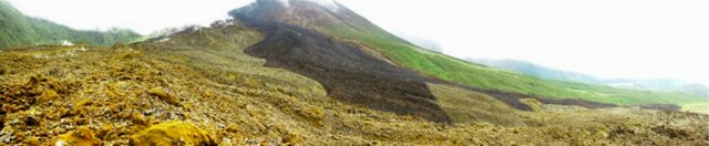 |
Figure 31. Panoramic view from the sequential camera of lava flows at Reventador. Courtesy of S. Vallejo. |
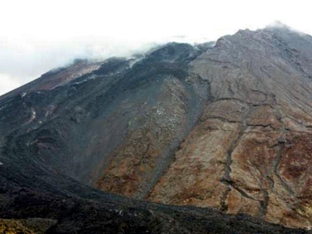 |
Figure 32. At Reventador, a photo taken on 16-17 September 2009 of the actively growing dome in the summit crater. Courtesy of J. Bourquin. |
Thermal images and SO2 measurements were collected near the caldera, and lavas were sampled. SO2 flux measurements (table 4) were collected both by helicopter and by car (figure 33). A telescope for the SO2 measurements sat below the helicopter blades and those spinning blades may have interfered with the measurements. The values presented may thus underestimate the SO2 fluxes.
Table 4. Reventador SO2 data collected from helicopter on 16 and 17 September 2009. The transects in the first column are indicated on figure 33. Transect 34 measurements clearly indicated that the SO2 gas plume had divided (bifurcated) and the two plumes appear as 34a and 34b. For this transect, the SO2 fluxes were calculated separately for each lava plume segment, than added to get the total emission. Land-based measurements, transects 43 and 46, were collected S and W of the vent. Courtesy of IG.
| Transect/Route | Wind speed (m/s) | Wind direction | Data number | Offset | SO2 flux (t/d) | Plume Width | Traverse Length | Intensity Limit |
| 31 | 5 | 281 | 191 | -28 | 811 | 1.9 km | 52.2 km | 7 |
| 34a | 5 | 270 | 95 | -1 | 1,425 | 3.6 km | 22.2 km | 7 |
| 34b | 5 | 326 | 124 | -8 | 795 | 2.5 km | 49.2 km | 7 |
| 34 Total | -- | -- | 215 | -- | 2,220 | -- | -- | -- |
| 35 | 5 | 337 | 84 | -28 | 616 | 1.6 km | 22.8 km | 5 |
| 36 | 5 | 349 | 147 | -16 | 557 | 2.1 km | 30.2 km | 8 |
| 43 | 5 | 202 | 471 | -14 | 283 | 5.2 km | 42.8 km | 5 |
| 46 | 5 | 236 | 1222 | -14 | 1,264 | 16 km | 116 km | 5 |
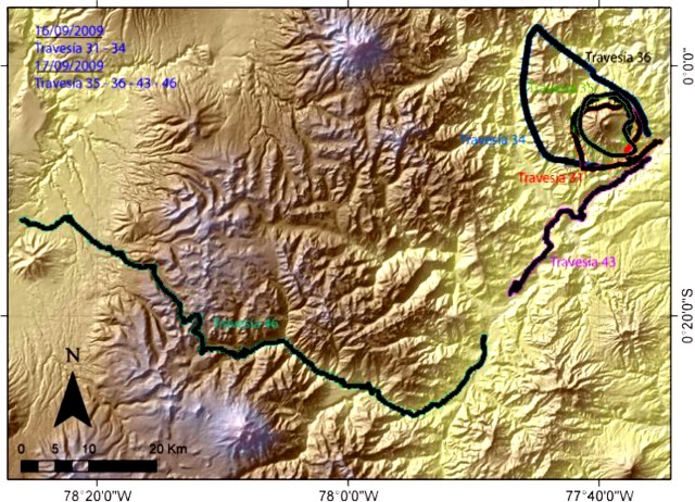 |
Figure 33. Map of Reventador illustrating transects made (in colored version, each transect is in a different color). Transects 31 and 34 were conducted on 16 September; transects 35, 36, 43 and 46 were conducted on 17 September. Courtesy of IG. |
Based on a pilot observation, the Washington VAAC reported that on 21 September a plume rose to an altitude of 7.6 km. An ash plume on 4 October drifted W. In both cases, ash was not seen in satellite imagery, although meteorological clouds were present. In the latter case, an occasional thermal anomaly was observed.
Thermal anomalies over the crater area were detected in MODIS satellite imagery on 6, 11, and 13 October. On 13 October, the OMI satellite sensor indicated that the SO2 concentration in the atmosphere near the volcano had increased. On 14 October, seismicity increased and harmonic tremor was detected. A seismic station located at ~ 2,600 m elevation on the NE flank of the cone detected rockfalls. Several people living in the area reported roaring noises and had observed slight incandescence from the crater during the previous few nights.
During an overflight on 16 October, scientists saw the lava dome and a lava flow on the NE flank (figure 34). Bluish gases were being emitted. According to a thermal camera, the incandescent parts in the crater were about 300°C. Other observers heard roaring noises and sounds resembling "cannon shots." Incandescent blocks were ejected from the crater, and steam and gas rose 100 m and drifted SW. Incandescent material was seen on the S flank.
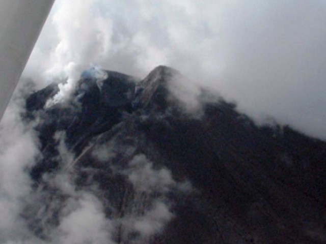 |
Figure 34. Aerial photo taken on the N side of Reventador on 16 October 2009 showing the lava dome amid weather clouds and some heavy steaming from the NE-flank lava flow. Courtesy of IG. |
On 17 October, long period (LP) earthquakes and volcanic explosions lasting up to 10 hours were registered, incandescence on the S flank was noted, and noises similar to the previous day were again heard. A small gray plume was seen the next day. On 19 October, thermal anomalies were again detected on satellite imagery. During an overflight, blue gas plumes containing SO2 were seen (figure 35). The lava flow on the S flank occupied a large area and was divided into two branches.
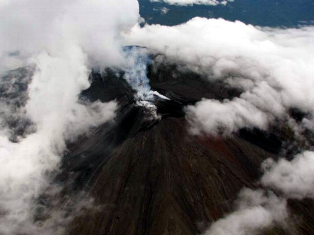 |
Figure 35. Photograph of the E side of Revantador's cone taken the morning of 19 October 2009. Note steam rising from dome summit and lava flows on volcano's flanks. Courtesy of IG. |
According to the IG, on 21 October, steam-and-gas plumes with little to no ash rose 2-4 km above the crater and drifted in various directions. An explosion that day ejected incandescent material from the crater and blocks rolled down the flanks. On 22 October, a few explosions generated ash-and-steam plumes that rose 4 km. Observations during an overflight revealed a small lava flow on the N flank and a larger flow with four branches on the S flank (figure 36). Part of the lava dome base had disappeared and small spines were present, especially on the S side of the dome. Thermal images revealed that material in the crater was 400°C and the lava-flow fronts were 250°C. Cloudy weather prevented visual observations during 23-26 October. Roaring noises were heard on 25 October.
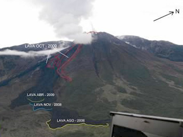 |
Figure 36. Aerial photograph displaying the distribution of lava flows on the N side of Reventador's caldera on 22 October 2009. Courtesy of S. Vallejo. |
Geological Summary. Volcán El Reventador is the most frequently active of a chain of Ecuadorian volcanoes in the Cordillera Real, well east of the principal volcanic axis. The forested, dominantly andesitic stratovolcano has 4-km-wide avalanche scarp open to the E formed by edifice collapse. A young, unvegetated, cone rises from the amphitheater floor to a height comparable to the rim. It has been the source of numerous lava flows as well as explosive eruptions visible from Quito, about 90 km ESE. Frequent lahars in this region of heavy rainfall have left extensive deposits on the scarp slope. The largest recorded eruption took place in 2002, producing a 17-km-high eruption column, pyroclastic flows that traveled up to 8 km, and lava flows from summit and flank vents.
Information Contacts: Geophysical Institute (IG), Escuela Politécnica Nacional, Apartado 17-01-2759, Quito, Ecuador (URL: http://www.igepn.edu.ec/); Washington Volcanic Ash Advisory Center, Satellite Analysis Branch (SAB), NOAA/NESDIS E/SP23, NOAA Science Center Room 401, 5200 Auth Rd, Camp Springs, MD 20746, USA (URL: http://www.ospo.noaa.gov/Products/atmosphere/vaac/); Hawai'i Institute of Geophysics and Planetology (HIGP) Thermal Alerts System, School of Ocean and Earth Science and Technology (SOEST), University of Hawai'i, 2525 Correa Road, Honolulu, HI 96822, USA (URL: http://modis.higp.hawaii.edu/).