Report on San Vicente (El Salvador) — October 2009
Bulletin of the Global Volcanism Network, vol. 34, no. 10 (October 2009)
Managing Editor: Richard Wunderman.
San Vicente (El Salvador) Landslide in November 2009 after heavy rains
Please cite this report as:
Global Volcanism Program, 2009. Report on San Vicente (El Salvador) (Wunderman, R., ed.). Bulletin of the Global Volcanism Network, 34:10. Smithsonian Institution. https://doi.org/10.5479/si.GVP.BGVN200910-343070
San Vicente
El Salvador
13.5969°N, 88.8375°W; summit elev. 2149 m
All times are local (unless otherwise noted)
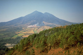
During 7-8 November 2009, heavy rains caused landslides and flooding in areas NE to NW of San Vicente in central El Salvador (figure 12), resulting in flooded rivers, buried homes and car, and casualties. The most recent volcanic activity consisted of lava flows that were covered by an eruption of neighboring Ilopango volcano in 260 AD. According to the USGS, previous earthquake-and rainfall-triggered landslides and lahars occurred in 1774, 1934, 1996, and 2001. In 1774, a lahar on the NE flank affected the town of San Vicente. The 1934 lahar on the N flank destroyed the town of Tepetitan, more than 6 km from the summit. In 1996, landslides and lahars on the S flank damaged the major roadway between Tecoluca (17 km NW) and Zacatecoluca (6 km SSW). On 13 February 2001, a M 6.6 earthquake caused more than 25 landslides on the N and NW flanks of the volcano that reportedly killed 39 people. However, no subsequent volcanic activity occurred from San Vicente, San Miguel, San Salvador, or Santa Ana volcanoes.
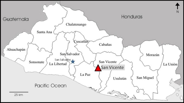 |
Figure 12. Location map of San Vicente volcano in the Departamento of San Vicente, in El Salvador. The country is divided into 14 Departamentos; five of these were affected by the 7-8 November events. The capital is San Salvador, 40 km WNW of San Vicente. |
Frequent and heavy rains on 7 November 2009 and into the next morning caused landslides, lahars, and flooding in the major drainages around the northern flanks of San Vicente. Servicio Nacional de Estudios Territoriales (SNET) reported that debris flows traveled up to 7 km away, severely affecting roads and towns. Loss of life and property were particularly severe in Verapaz, population ~ 3,000, (about 6 km NW of the summit) and Guadalupe (5 km NW from the summit, on the flanks), although damage was reported in several areas, including in the capital of San Salvador, 40 km WNW. According to the Pan American Health Organization (PAHO), the rate of rainfall at San Vicente volcano was 81 mm/hour, for a total of 355 mm in a 24-hour period. Five of the 14 Departamentos were affected by events caused by the rainfall: San Vicente, La Paz, La Libertad, San Salvador, and Cuscatlán.
On 9 November an eyewitness living in Verapaz noted in media reports that, "It was about two in the morning when the rain started coming down harder, and the earth started shaking... The next thing I knew I was lying among parts of the walls of my house." Another resident stated, "I started to hear roaring noises and the ground began to shake. Then my windows broke and lots of mud came in..." According to news articles, about 300 houses were flooded when a river in the town overflowed. Extensive damage was done to roads (figure 13), water and power sevices, and croplands in Verapaz.
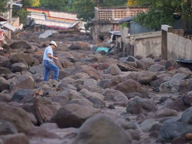 |
Figure 13. A resident walks through an area hit by a landslide after torrential rains in Verapaz, El Salvador, on 9 November 2009. Photo by Yuri Cortez, AFP/Getty Images. |
In the capital of San Salvador, eyewitnesses described an area of 8 km2 that had been covered by rocks, mud, and debris, and that many houses and hamlets had completely disappeared. At least six bridges were swept away and landslides blocked major and secondary roads, cutting communication and hindering clean-up efforts.
Based on information from PAHO, the number of people in shelters peaked on 16 November at 15,090. As of 22 November, 198 people had died, 77 were missing, and 5,759 remained in shelters. The estimated number of affected people was 75,000.
Geological Summary. San Vicente stratovolcano, also known as Chichontepec, is ~20 km SE of Lake Ilopango. The andesitic edifice with two summit peaks was constructed within the Pleistocene La Carbonera caldera, whose rim is visible only on its SW side. The N and S flanks are covered by lava flows from the central vent, but lava flows on the eastern side originated from a vent on the upper flank. Volcanism has continued into the Holocene, but the latest lava flows are covered by deposits from the major Tierra Blanca eruption from Ilopango around 450 CE. Reports of eruptions in 1643 CE and 1835 CE are false (Catalog of Active Volcanoes of the World; Sapper, 1917), but numerous hot springs and fumaroles are found on the N and W flanks.
Information Contacts: Servicio Nacional de Estudios Territoriales (SNET), Km. 5 1/2 carretera a Santa Tecla y Calle las Mercedes, contiguo a Parque de Pelota, Edificio SNET, Apartado Postal 27, Centro de Gobierno, El Salvador 2283-2246 (URL: http://www.snet.gob.sv/); Pan American Health Organization (PAHO) - El Salvador, 73 Avenida Sur No. 135, Colonia Escalón, San Salvador, El Salvador (URL: http://devserver.paho.org/els/); Associated Press (URL: http://www.ap.org/); Los Angeles Times, 202 West 1st Street, Los Angeles, CA 90012, USA (URL: http://www.latimes.com/); BBC News (URL: http://news.bbc.co.uk/).