Report on Kilauea (United States) — January 2010

Bulletin of the Global Volcanism Network, vol. 35, no. 1 (January 2010)
Managing Editor: Richard Wunderman.
Edited by Sally Sennert.
Kilauea (United States) 2008 highlights: Thanksgiving Eve Breakout continues, Halema'uma'u Crater vent opens
Please cite this report as:
Global Volcanism Program, 2010. Report on Kilauea (United States) (Sennert, S., and Wunderman, R., eds.). Bulletin of the Global Volcanism Network, 35:1. Smithsonian Institution. https://doi.org/10.5479/si.GVP.BGVN201001-332010
Kilauea
United States
19.421°N, 155.287°W; summit elev. 1222 m
All times are local (unless otherwise noted)
This report summarizes Kīlauea activity for 2008. The previous report (BGVN 34:03) discussed the Father's Day Intrusion, lava in Pu`u `O`o Crater, and the Thanksgiving Eve Breakout (TEB), covering activity during the last half of 2007. The current report will very briefly highlight a few of the events previously discussed, leading into 2008, starting with a summary of the ongoing TEB activity. Other major events include activity in Pu`u `O`o crater and a vent opening in Halema'uma'u crater. All information is based on reports from the Hawaiian Volcano Observatory (HVO).
As discussed in BGVN 34:03, lava erupted from four fissures that extended 1.7 km E from an area near the E rim of Pu`u `O`o crater on 21 July 2007 (BGVN 34:03), defining an approximately 2-km-long segmented line. The fissures fed lava flows and created perched lava flows and lava ponds that frequently overflowed. By 12 August, only one fissure ("D") remained active.
On 21 November, lava escaped from a perched channel near fissure D and became known as the Thanksgiving Eve Breakout, or TEB. Flowing lava built rootless shields of various sizes. One large shield towered ~ 40 m above the pre-July 2007 surface; about 15 total were built in a 3-month period.
The TEB flow field and ocean entries. After the opening of the fissures on 21 and 22 July 2007 and the TEB event on 21 November 2007, lava flows continued to be active in 2008, expanding the flow field. The area of the flow field roughly doubled in 2008, rising from 11.5 to 25.1 km2 (figure 194).
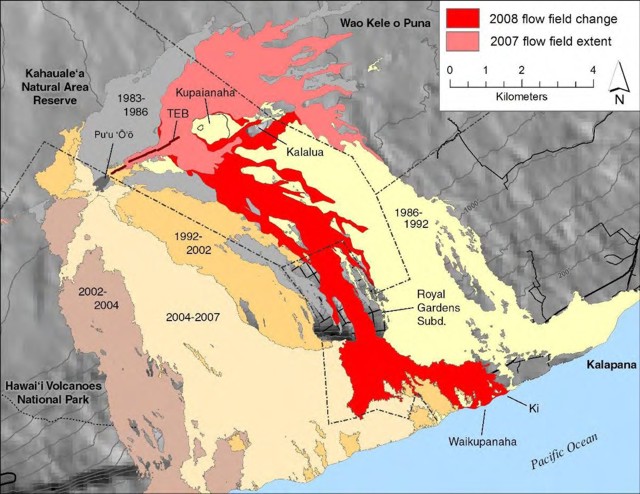 |
Figure 194. Map of Kīlauea showing the expansion of the lava flow field during 2008. Fissures A, B, C, and D appear as an almost continuous line between Pu`u `O`o crater and the TEB vent. The darker color shows the area covered by lava in 2008 as the flows traveled S and E of the TEB vent, through the now-abandoned Royal Gardens subdivision, to the Waikupanaha and Ki ocean entries. Courtesy of USGS-HVO. |
In January and February 2008, the perched channel that had previously been active filled a few times, and occasionally overflowed, sending lava flows S, SE, and E. After 10 February, no lava erupted in the perched channel through the rest of 2008. Occasional collapses at rootless shields generated local `a`a lava flows. Around 20 February, shallow lava in the main TEB vent disappeared and intense fuming ensued. About the same time, the TEB flow transitioned from shield-building activity to distributing pahoehoe lava flows. By the end of February, advancing `a`a lava flows had entered the Royal Gardens subdivision and split into two, a W lobe and an E lobe named Prince and Royal (after the streets they mainly were restricted to), respectively. By 7 March, six structures in the subdivision had been destroyed.
On 5 March the W lobe reached the ocean at the Waikupanaha entry, named for a nearby pond lava covered in the 1990s. This was the first lava flow to reach the ocean in almost a year, since 20 June 2007, following the Father's Day intrusion. The lava began building out the delta at multiple locations, and on 12 March, created the Ki entry at a new location 200 m E of Waikupanaha. There were a few small collapses on the newly formed deltas at the end of March. By 28 March, new land forming at the Waikupanaha and Ki entries merged to create a continuous 2.18-km-long, 115-m-wide delta, covering an area of 9.16 hectares. Lava poured into the sea at the Ki entry until mid-April.
Significant littoral explosions, characterized by tephra ejected 20 m high, were first seen at the W entry of Waikupanaha on 5 April. Explosions were occasionally seen throughout April and early May, and were last seen on 10 May. The explosions then occurred at different Waikupanaha locations through June; tephra jets were commonly less than 50 m high.
Incandescence from the TEB vent was noted during 31 March-15 April and 2 May-2 June. The tube system carrying the lava from the TEB vent down to the ocean was relatively stable during May and June. One surface flow, on the pali (fault scarp), was seen in May and a few flows were seen in June. In some stretches, the lava tube would split into two tubes and then merge again, forming braided structures. Near the ocean, the tube split and created multiple ocean entry points. On 6 May, spatter was seen at the multiple ocean entries of Waikupanaha, and on 9 May, a new littoral cone was seen. Littoral explosions were common during May and June. On 3 June, a collapse caused the delta shoreline to move back 30 m.
Tephra jets observed at Waikupanaha in the latter part of June (figure 195) continued into July. A bench collapse on 2 July was followed by a few days of intense bubble bursts and large tephra jets. On 9 and 10 July tephra jets were estimated to be ~ 40 m high.
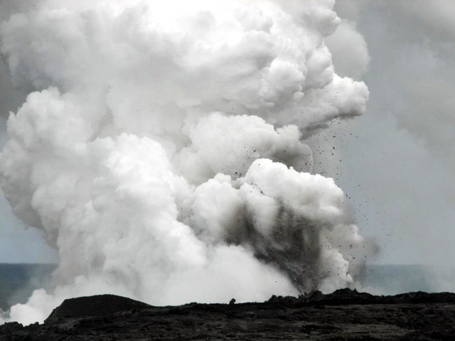 |
Figure 195. Airborne debris ejected from explosions was seen in the white steam plume generated from lava flow entering the ocean at Kīlauea's Waikupanaha ocean entry on 24 June 2008. Courtesy of USGS-HVO. |
In early July, breakout lava flows originated from the rootless shield area. Lava also continued to flow SE through a lava tube system to the Waikupanaha ocean entry. On 7 July, a breakout from one of the shields (number 3) was comprised of three vents, each emitting lava fountains. One of the fountains was arch-shaped and reached 12-14 m high. It built a large spatter cone. Also, an `a`a flow resulting from the fountaining traveled 1.4 km E. Strands of Pele's hair created by the fountain were carried at least as far as the end of the Chain of Craters road. The lava flow was inactive by 17 July. Other breakouts on the pali were active until 25 July, when incandescence was not longer seen. On 30 July, less than one hectare (or 25 %) of the bench E of the ocean entry had collapsed.
On 9 August. Lava again flowed to the upper reaches of the Royal Gardens subdivision. On 20 August, geologists observed bursting lava bubbles from an area E of Waikupanaha that threw molten fragments 10-20 m into the air. A delta collapse ejected lithics up to 180 m inland. Rocks were mostly 5-10 cm in diameter, with many larger blocks around 25 cm across. Multiple surface lava flows on the pali were noted; on 16 October a channelized 'a'a flow was active in the Royal Gardens subdivision and a pahoehoe flow was seen on the W side of the active flow field. Lava destroyed one of two remaining intermittently occupied structures in the subdivision.
During August through December 2008 lava flowed SE through tubes underneath the TEB and rootless shield complex and flowed into the ocean at Waikupanaha with few pauses. Thermal anomalies detected by satellite and visual observations revealed intermittent active lava flows at locations on and at the base of the pali, at the TEB vent, and on the coastal plain. Periodic explosions during September, October, and early November ejected debris into the air.
Lava flows and a new gas vent in Pu`u `O`o Crater. During January through April 2008, intermittent incandescence was seen in Pu`u `O`o crater through the web camera. Heavy fume that sometimes obscured views was particularly dense from April through June, although thermal images revealed hot spots on the crater floor in late April.
A flash of incandescence on 20 May signaled a new gas vent opening. On 23 May, an overflight of Pu`u `O`o crater revealed that the new gas vent was about 6 m wide and centered 21 m below the E rim. It jetted gas at temperatures as high as 600°C. Gas continued to jet from the vent during 28 May-17 June.
The SO2 emission rate was high on 27 and 30 May and fluctuated between 2,740 and 4,700 metric tons per day (t/d). The background rate of about 2,000 t/d (averaged over the past 25+ years) was measured on 25 May and earlier. The rate continued to be above the background in early June, fluctuating between 1,530 and 3,080 t/d. Incandescence from two distinct sources in the E and W ends of Pu`u `O`o crater was observed on the web camera during 4-6 July. During this period, the SO2 emission rate fluctuated between 3,100 and 4,800 t/d. Diffuse incandescence was noted on 7 and 8 July, and then spattering was visible in the webcam on the crater's N rim.
Scientists that visited the area on 10 July heard gas bursts and spattering. They saw active lava with a Forward Looking Infrared Radiometer (FLIR) camera. It came from a spattering vent, corresponding in location to the West vent from July 2007 and to the Beehive vent from prior activity. This vent sat in the lowest part of the crater and fed lava that traveled SE and pooled. Spatter bursts ejected lava 20-30 m high. There was also very weak spattering from a vent at the SE edge of the lava pond and from a vent on the E side of the crater floor. The SO2 emission rate was very high at 6,300 t/d on 17 July. During the rest of July, incandescence was observed from vents and sporadic spatter in Pu`u `O`o crater.
SO2 measurements sporadically obtained at Pu`u `O`o during July and August showed that the rate remained above background levels, between 1,700 and 5,400 t/d. Sometime on 11 and 12 September incandescence flashed from multiple sources within the central and western parts of Pu`u `O`o crater. A little over a week later, the SO2 emission rate dropped to below or remained at the 2,000 t/d background rate and remained there until early November.
In early December, HVO noted that GPS stations spanning Pu`u `O`o had recorded almost 4 cm of contraction during the previous 3 months. On 16 December, a Pu`u `O`o webcam was hit with a small amount of debris, suggesting a collapse in the crater.
Vent opens in Halema`uma`u Crater. In early January 2008, SO2 emission rates at the summit increased as much as ten times the background value. The rate averaged 140 tons per day during 2003-2007 . The increased gas emissions at Halema`uma`u caused the temporary closure of the National Park in late February. The prevailing trade winds blow SW over the Ka`u Desert. However high concentrations of SO2 affected other areas of the National Park, such as Jaggar Museum, HVO, and the town of Hilo when the winds changed direction. Poor air-quality conditions resulted in park closings and evacuations twice during 2008.
On 12 March a new gas vent appeared just above the base of the SE wall of the crater (see map and cross section of the crater and vicinity in BGVN 32:06). The SO2 emission rate abruptly increased that day and remained at 1,600-2,500 during 12-16 March. On 16 March, emission rates reached 2,500 tons per day, the highest level at the summit since measurements began in 1979.
During 13-18 March, incandescence from the new gas vent originated from a spot ~ 30 m wide within the rubble at the base of the E crater wall. Cracking rocks, an effect possibly due to thermally-induced stress, were heard by scientists at the Halema`uma`u overlook. On 17 March, the area of incandescence appeared slightly enlarged with a new area higher on the crater wall and to the N.
On 19 March, gravitational collapses of rubble in the vent led to an explosion that scattered debris over an area of about 30 hectares, covering a portion of Crater Rim Drive and damaging the overlook. On Crater Rim drive, the ejecta were up to 2 cm in diameter and increased in size and thickness towards the overlook. The largest block ejected was ~ 1 m3. Small impact craters created by 30-cm-diameter blocks were abundant in the overlook area. Since no lava was ejected, the event was possibly driven by hydrothermal or gas sources. The event was the first such explosive activity in the crater since 1924.
Seven other explosive eruptions occurred during the rest of 2008, ejecting both juvenile and lithic material: 9 April, 16 April, 1 August, 27 August, 2 September, 12 October, and 14 October. The majority of the explosions were preceded by collapse of a portion of the vent rim or wall, coincident with high-frequency seismic signals.
A majority of the time after the vent had opened, emissions of steam and gas, often containing minor amounts of ash and variously shaped glass fragments, rose from the vent. Typically the white-colored plume that rose from the vent drifted SW with the prevailing winds (figure 196). Often incandescence was seen at the base of the plume. Rock clattering, booming noises, and "rushing sounds" were occasionally heard in the vicinity of Halema`uma`u crater.
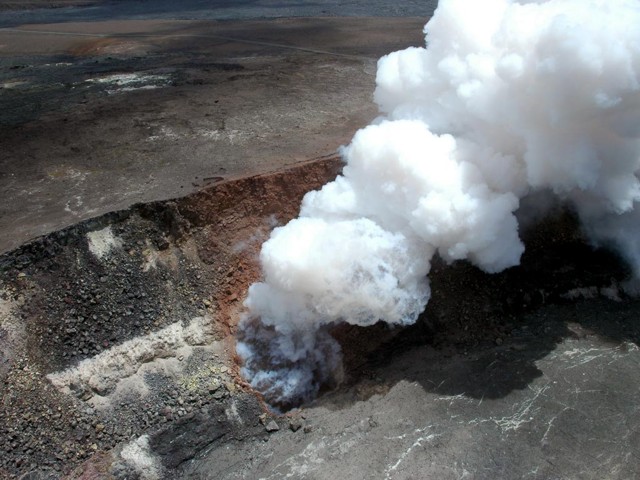 |
Figure 196. Aerial view on 8 August 2008 of the vent in Halema`uma`u crater that had opened on 12 March at the base of the E crater wall. A billowing white gas-and-steam plume is seen rising from the vent and drifting SW. On the rim, just above the vent, the damaged fence is visible. Courtesy of USGS-HVO. |
SO2 gas affected residents living downwind, and caused crop damage. According to a news report, the Hawaii County Civil Defense issued a health advisory on 7 April for those living downwind of both Halema`uma`u and Pu`u `O`o craters. Residents of specified areas were then advised by the State Department of Health to evacuate because of projected dangerous levels of SO2. Residents of other areas were put on alert. A few weeks later, during 24-25 April, Hawaii Volcanoes National Park closed again due to elevated levels of SO2; about 2,000 people were evacuated.
On 21 August, an earthquake was accompanied by a 400-m-high jet of mostly gas that rose vertically, then drifted SW. The jet also contained some rock dust and bits of volcanic glass. Several small ash ejections occurred on 25 and 26 August.
On 5 September, scientists in a helicopter saw the surface of a sloshing lava lake, 50 m in diameter and ~ 100 m below the vent rim. The lake was later described as a roiling pond with multiple bursting bubbles that changed into a central upwelling circulation pattern. The level of the lake dropped slightly before the cycle restarted. The lava lake was seen several more times in the following weeks.
After the 14 October explosive eruption, collapses from the vent rim and walls caused "dusty" plumes, along with the almost constant steam plume. Thermal images collected on 24 October showed that the lava lake had drained from the vent's upper pit-like cavity and dropped out of sight below the mouth of a smaller (~ 15 x 30 m) lens-shaped opening near the base of the vent's northern (crater-side) wall. Other aerial views of the vent seen through 20 November showed a similar situation. On 4 December, a large collapse within the vent ejected a big "dust" cloud that blanketed the overlook area with reddish ash. Several more collapses during 5-6 December widened the vent by several meters; on 19 December, the vent was ~ 90 m in diameter. Small collapses continued to shed rubble into the vent through December 2008 and, by the end of the month, aerial views with an infrared camera showed that the lens-shaped opening at the bottom of the vent's pit had become choked with debris.
Geological Summary. Kilauea overlaps the E flank of the massive Mauna Loa shield volcano in the island of Hawaii. Eruptions are prominent in Polynesian legends; written documentation since 1820 records frequent summit and flank lava flow eruptions interspersed with periods of long-term lava lake activity at Halemaumau crater in the summit caldera until 1924. The 3 x 5 km caldera was formed in several stages about 1,500 years ago and during the 18th century; eruptions have also originated from the lengthy East and Southwest rift zones, which extend to the ocean in both directions. About 90% of the surface of the basaltic shield volcano is formed of lava flows less than about 1,100 years old; 70% of the surface is younger than 600 years. The long-term eruption from the East rift zone between 1983 and 2018 produced lava flows covering more than 100 km2, destroyed hundreds of houses, and added new coastline.
Information Contacts: Hawaiian Volcano Observatory (HVO), U.S. Geological Survey, PO Box 51, Hawai'i National Park, HI 96718, USA (URL: https://volcanoes.usgs.gov/observatories/hvo/); Honolulu Advertiser (URL: http://www.honoluluadvertiser.com); Associated Press (URL: https://www.ap.org/)