Report on Kizimen (Russia) — February 2010
Bulletin of the Global Volcanism Network, vol. 35, no. 2 (February 2010)
Managing Editor: Richard Wunderman.
Kizimen (Russia) Seismic crisis starting in July 2009 (up to 120 earthquakes per day)
Please cite this report as:
Global Volcanism Program, 2010. Report on Kizimen (Russia) (Wunderman, R., ed.). Bulletin of the Global Volcanism Network, 35:2. Smithsonian Institution. https://doi.org/10.5479/si.GVP.BGVN201002-300230
Kizimen
Russia
55.131°N, 160.32°E; summit elev. 2334 m
All times are local (unless otherwise noted)
Earthquakes at Kizimen appeared in July 2009 and increased substantially in the middle of that month (figures 1 and 2). During 11 July 2009 to 6 April 2010 instruments recorded 1,940 earthquakes. The largest number of seismic events took place during July and reached up to 120 a day. On 20 August instruments also recorded weak, faltering, and spasmodic volcanic tremor. Witnesses near the volcano felt shaking from many earthquakes, sometimes accompanied by an underground rumble.
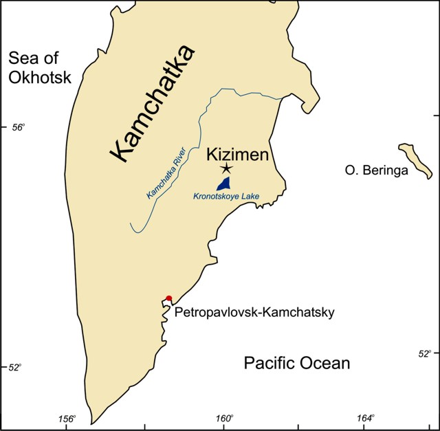 |
Figure 1. Sketch map showing location of Kizimen on the Kamchatkan Peninsula. |
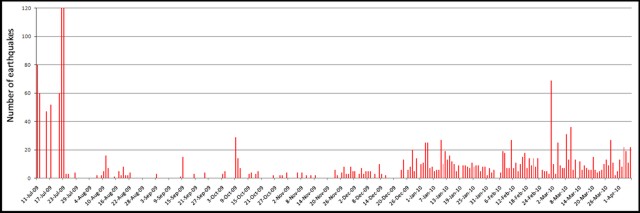 |
Figure 2. A plot of seismic events at Kizimen during July 2009 to April 2010. A new station was installed around the beginning of 2010, accounting for the increased number of recorded events then. Plotted data taken from online reporting by the Kamchatka Branch of the Geophysical Service of the Russian Academy of Sciences (KB GS RAS). |
In August 2009 scientists from Institute of Volcanology and Seismology researched the fumarolic field on the NW slope (figures 3 and 4). The temperature on the NW part of the field had risen from 181°C to 235°C. On the SW part of the volcano it changed from 171°C to 340°C. On the central part it was 340°C.
|
Figure 3. Fumarolic gases escaping at Kizimen, August 2009. Scientists are sampling the gases and condensate (left center). Photo by Alexandr Ovsyannikov. |
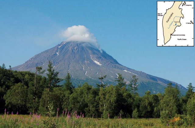 |
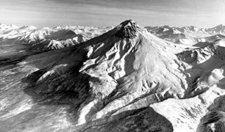
Figure 4. View from the NE looking at Kizimen with a cloud-covered summit and patches of snow. Photo by Igor Tembrel (Tembrel and Ovsyannikov, 2009). |
The volcano sits in an area that is structurally complex, the scene of intense tectonism and extensive modern deformation. According to Melekestsev and others (1995), Kizimen is "located on the SE flank of the Shchapinsky graben and is confined to a system of large amplitude NE-striking faults that includes the junction of the graben with the horst of the Tumrok ridge."
References. Tembrel, I., and Ovsyannikov, A., 2009, The condition Kizimen volcano on summer 2009: Kamchatka, Vestnik KRAUNC, Earth Science Series; Petropavlovsk-Kamchatsky, v. 14, p. 7-9 [ISSN 1816-5524]. (in Russian)
Melekestsev, I., Ponomareva, V., and Volynets, O., 1995, Kizimen volcano (Kamchatka)?a future Mount St. Helens?: Journal of Volcanology and Geothermal Research, v. 65, p. 205-226.
Geological Summary. Kizimen is an isolated, conical stratovolcano that is morphologically similar to St. Helens prior to its 1980 eruption. The summit consists of overlapping lava domes, and blocky lava flows descend the flanks of the volcano, which is the westernmost of a volcanic chain north of Kronotsky volcano. The 2334-m-high edifice was formed during four eruptive cycles beginning about 12,000 years ago and lasting 2000-3500 years. The largest eruptions took place about 10,000 and 8300-8400 years ago, and three periods of long-term lava dome growth have occurred. The latest eruptive cycle began about 3000 years ago with a large explosion and was followed by intermittent lava dome growth lasting about 1000 years. An explosive eruption about 1100 years ago produced a lateral blast and created a 1.0 x 0.7 km wide crater breached to the NE, inside which a small lava dome (the fourth at Kizimen) has grown. Prior to 2010, only a single explosive eruption, during 1927-28, had been recorded in historical time.
Information Contacts: Kamchatka Volcanic Eruptions Response Team (KVERT), Institute of Volcanology and Seismology (IV&S) Far East Division, Russian Academy of Sciences (FED RAS); Kamchatka Branch of the Geophysical Service of the Russian Academy of Sciences (KB GS RAS), Piip Ave. 9, Petropavlovsk-Kamchatsky, 683006, Russia (URL: http://www.kscnet.ru/ivs, http://www.emsd.ru/~ssl/monitoring/main.htm); Alexandr Ovsyannikov and Igor Tembrel, IV&S FED RAS.